
Liverpool Plains Shire is a local government area located in the North West Slopes region of New South Wales, Australia. The Shire was formed on 17 March 2004 by the amalgamation of Quirindi Shire with parts of Parry, Murrurundi and Gunnedah shires.

Gerringong is a town located about ten minutes drive south of Kiama, and about twenty minutes north of Nowra in the Illawarra region of New South Wales, Australia in the Municipality of Kiama. At the 2021 census, Gerringong had a population of 4,165. One theory says that the name derives from an Aboriginal word meaning "fearful place".
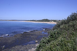
Sawtell is a suburb of the City of Coffs Harbour in northern New South Wales, Australia. It borders Toormina to the West.

Quirindi is a small town on the North West Slopes region of New South Wales, Australia, in Liverpool Plains Shire. At the 2021 census, Quirindi had a population of 2,602. It is the nearest link to Gunnedah to the northwest and Tamworth to the north. The local economy is based on agriculture, with broadacre farming dominant on the black soil plains to the west and livestock grazing in the hilly eastern part of the district.

Iluka is a small village at the mouth of the Clarence River in north-eastern New South Wales, Australia. It is situated directly across the river from the resort town of Yamba. At the 2021 census, Iluka had a population of 1,764 people. The town's name is derived from an Aboriginal word meaning 'near the sea', the name was likely derived from the Dhanggati language term 'yiluga'.

Werris Creek is a small town in New South Wales, Australia, near Tamworth, in Liverpool Plains Shire. It is north of Quirindi and is at the junction of the Main North railway line to Armidale and Moree. At the 2011 census, Werris Creek had a population of 1,437.
Culburra Beach, commonly referred to as Culburra, is a town located in the South Coast region of New South Wales, Australia. Located within the Shoalhaven local government area, the town is 18 kilometres (11 mi) east-southeast of Nowra on Jerrinja Wandi Wandian Aboriginal Country. At the 2016 census, the town had a population of 2,874 and is the regional centre for the coastal villages of Currarong, Callala Beach, Callala Bay and Orient Point.

Hyams Beach is a seaside village in the City of Shoalhaven, New South Wales, Australia, on the shores of Jervis Bay. At the 2016 census, it had a population of 112. The village, 180 km south of Sydney, is bordered by two beaches, Chinaman's Beach to the north and Seaman's Beach to the south, with Hyams Beach being in the centre. A seaside resort, its beach is known for having turquoise/aqua-coloured waters and fine, squeaky, brilliantly white sand composed of pure quartz.

Fingal Bay is the easternmost suburb of the Port Stephens local government area in the Hunter Region of New South Wales, Australia. The only population centre is the township of the same name, which itself is named after the adjacent, small, semi-circular bay. At the 2021 census, the population of the town was 1,635.
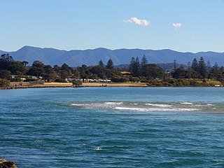
Urunga is a small town located within the Mid North Coast region of New South Wales, Australia, in Bellingen Shire. It is famous for its surf spots. At the 2021 census, Urunga had a population of 3,185. The town is south of Coffs Harbour and Sawtell and north of Nambucca Heads. The place name is derived from the Gumbaynggir word Yurūnga, which is derived from the word for long yurūn in reference to "long white sands".

The Municipality of Kiama is a local government area in the Illawarra region of New South Wales, Australia. The area is situated south of Shellharbour and the City of Wollongong and is located adjacent to the Pacific Ocean, the Princes Highway and the South Coast railway line.
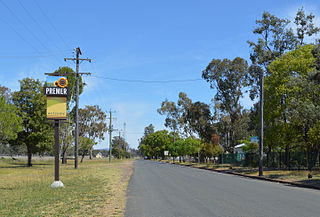
Premer is a small town in North-Western New South Wales, Australia. At the 2021 census, Premer had a population of 126 people.

One Mile is a suburb of the Port Stephens local government area in the Hunter Region of New South Wales, Australia. The Worimi people are the traditional owners of the Port Stephens area. The suburb is semi-rural with a small urban settlement, several eco-resorts and back-packer accommodations to the west of Gan Gan Road. On the beach side there is a residential land-lease community and three tourist parks. The parks, two of which have licensed restaurants, are positioned to provide quick access to the suburb's two beaches. Since late 2017 Port Stephens Koala Hospital has been operating in the grounds of Treescape resort.

Scotts Head is a coastal village of the Nambucca Valley local government area in the Mid North Coast region of New South Wales, Australia. Located on the coast of the Pacific Ocean, approximately 10 kilometres (6 mi) from the Pacific Highway and 480 kilometres (300 mi) from Sydney, it stretches southwards from just south of the mouth of the Nambucca River to the town of Scotts Head in the south.

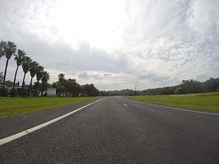
Spring Ridge is a small town in northeastern New South Wales, Australia. In the 2021 census the population of the town was 266. It is in the electoral district of Upper Hunter and the federal division of New England.
Duri is a village south of Tamworth in the New England region of New South Wales, Australia. It lies on the Werris Creek Road and the Main North railway line. At the 2011 census, Duri had a population of 534.
Tomakin is a small seaside village on the south coast of New South Wales between the major towns of Batemans Bay and Moruya. At the 2021 census, the town had a population of 1,233. It is most closely flanked by the other small villages of Guerilla Bay and Mossy Point.
Kiama Heights is a semi-rural locality in the Illawarra, south of Kiama in New South Wales, Australia. It is located on the coast of the Tasman Sea on either side of the Princes Highway. At the 2021 census, it had a population of 878.
Yellow Rock Ridge is a suburb of Wollongong in the City of Shellharbour in New South Wales, Australia.

Conjola Park is a beach resort in the City of Shoalhaven, New South Wales, Australia. It lies on the south shore of a lagoon called Conjola Lake, just to the east of the Princes Highway on Lake Conjola Entrance Road, which connects to the resort of Lake Conjola. It lies about 15 km north of Ulladulla and 215 km south of Sydney. At the 2016 census, it had a population of 340.

