
The Oxley Wild Rivers National Park is a protected national park that is located in the Northern Tablelands region of New South Wales, Australia in the Port Macquarie-Hastings City Council and Walcha Shire councils. The 145,223-hectare (358,850-acre) park is situated 445 kilometres (277 mi) north of Sydney and is named in memory of the Australian explorer John Oxley, who passed through the area in 1818 and is one of the largest national parks in New South Wales.
Wollongong, informally referred to as "The Gong", is a city located in the Illawarra region of New South Wales, Australia. Wollongong lies on the narrow coastal strip between the Illawarra Escarpment and the Pacific Ocean, 68 kilometres south of central Sydney. Wollongong had an estimated urban population of 302,739 at June 2018, making it the third-largest city in New South Wales after Sydney and Newcastle and the tenth-largest city in Australia by population. The city's current Lord Mayor is Gordon Bradbery AM who was elected in 2021.

Berry is a small Australian village in the Shoalhaven region of the New South Wales South Coast, located 143 km (89 mi) south of the state capital, Sydney. It has many historical buildings which are listed on the New South Wales Heritage Register. Berry attracts many tourists who come to enjoy the diversity of landscapes, including coastal beaches, rich dairy farming, and forested mountains. The village hosts a local Produce Market which is held twice each month on the second Saturday and fourth Sunday. Together with Kiama 23 km (14 mi) to the north, Berry acts as a gateway through to other towns and villages along the South Coast of NSW via the Princes Highway and the South Coast railway line. Major highway building projects in and around Berry have now bypassed the village, creating uninterrupted motorway conditions for coastal travel south to Nowra and the South Coast and north to Wollongong and Sydney. This has resulted in the removal of all but local and visitor traffic within the village. Planning is underway to create a pedestrian-friendly precinct in and around Queens Street.
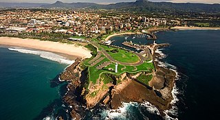
Kiama is a coastal town 120 kilometres south of Sydney in the Illawarra. One of the main tourist attractions is the Kiama Blowhole. Kiama features several popular surfing beaches and caravan parks, and numerous alfresco cafes and restaurants. Its proximity to the south of Sydney makes it an attractive destination for many day-trippers and weekenders.

The Illawarra is a coastal region in the Australian state of New South Wales, nestled between the mountains and the sea. It is situated immediately south of Sydney and north of the South Coast region. It encompasses the two cities of Wollongong, Shellharbour and the town of Kiama. Wollongong is the largest city of the Illawarra with a population of 240,000, then Shellharbour with a population of 70,000 and Kiama with a population of 10,000. These three cities have their own suburbs. Wollongong stretches from Otford in the north to Windang in the south, with Maddens Plains and Cordeaux in the west.
Gerringong is a town located about ten minutes drive south of Kiama, and about twenty minutes north of Nowra in the Illawarra region of New South Wales, Australia in the Municipality of Kiama. At the 2016 census, Gerringong had a population of 3,966. One theory says that the name derives from an Aboriginal word meaning "fearful place".

Jamberoo is a village on the South Coast of New South Wales, Australia in the Municipality of Kiama. It is approximately 11.3 km inland from Kiama. At the 2016 census, Jamberoo had a population of 1,667. The town's name is derived from an Aboriginal word meaning 'track'.

The Illawarra escarpment, or officially the Illawarra Range, is the fold-created cliffs and plateau-eroded outcrop mountain range west of the Illawarra coastal plain south of Sydney, in the state of New South Wales, Australia. The range encloses the Illawarra region which stretches from Stanwell Park in the north to Kiama, Gerringong and the Shoalhaven River in the south.

The South Coast refers to the narrow coastal belt from Shoalhaven district in the north to the border with Victoria in the south in the south-eastern part of the State of New South Wales, Australia. It is bordered to the west by the coastal escarpment of the Southern Tablelands, and is largely covered by a series of national parks, namely Jervis Bay National Park, Eurobodalla National Park, and Ben Boyd National Park. To the east is the coastline of the Pacific Ocean, which is characterised by rolling farmlands, small towns and villages along a rocky coastline, interspersed by numerous beaches and lakes.
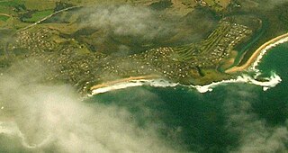
Minnamurra is a suburb in the Illawarra region of New South Wales, Australia, in the Municipality of Kiama. It has a station on City Rail South Coast line. The Minnamurra River flows into the ocean at Minnamurra. There is a sandy beach and a sand spit at the river mouth.

Saddleback Mountain is a mountain near Kiama in the Illawarra region of New South Wales, Australia. The mountain rises to about 600 metres (2,000 ft) above sea level on the Illawarra escarpment and has views of Noorinan Mountain, 662 metres (2,172 ft) above sea level, and Barren Grounds Plateau to the west and south to Coolangatta Mountain and Pigeon House Mountain to Ulladulla, and north over Lake Illawarra, the Illawarra escarpment and to the Cronulla Sandhills and Kurnell Oil Refinery on a clear day.

Burrawang is a village in the Southern Highlands of New South Wales, Australia in Wingecarribee Shire. According to the 2016 Australian census, Burrawang's population was 361.
The Minnamurra River, an open mature wave dominated barrier estuary, is located in the Illawarra region of New South Wales, Australia.

Dorrigo, a small town on the Waterfall Way, is located on the Northern Tablelands, in northern New South Wales, Australia. The town is part of Bellingen local government area.

Guioa semiglauca, known as the guioa or wild quince, is a rainforest tree of eastern Australia. It grows from Kioloa near Batemans Bay in southern New South Wales to Eungella National Park in tropical Queensland. It grows in many different types of rainforest, particularly common in regenerating areas and on sand in littoral rainforest.
Tumbulgum is a village in northern New South Wales, Australia. It is in the Tweed Shire local government area, at the confluence of the Rous and Tweed Rivers, 818 kilometres (508 mi) north east of the state capital, Sydney and 120 kilometres (75 mi) south east of Brisbane. At the 2006 census, Tumbulgum had a population of 349.
The 2011 Wollongong floods, beginning in March 2011, were a series of floods occurring throughout Wollongong and the Illawarra regions of New South Wales, Australia. The floods were the result of a storm cell covering most of the southern regions of the state and torrential rain in suburban Sydney and nearby regional areas.

Gerroa is a coastal town in the Municipality of Kiama, in the Illawarra region of New South Wales, Australia 133 kilometres south of Sydney. It is considered to be the southernmost town in the Illawarra region. Nearby towns are Gerringong, Kiama and Berry.
The Cambewarra Range Nature Reserve, as part of the Kangaroo Valley Group of Nature Reserves, is a protected area located on the cliffs and plateaus of the Kangaroo Valley in the Southern Highlands and South Coast regions of New South Wales in eastern Australia. The Reserve is situated approximately 150 kilometres (93 mi) south of Sydney, 50 kilometres (31 mi) southwest of Wollongong and 16 kilometres (9.9 mi) northwest of Nowra. The Reserve has a total area of 1684 hectares, and includes 11 privately owned properties. It is critical for it to be pristine for a variety of reasons, not the least the catchment of water, as the Reserve floor flows into the Kangaroo Valley River and the Shoalhaven River, from which the Sydney Water Authority draws water to supply large populations in Sydney and Wollongong.
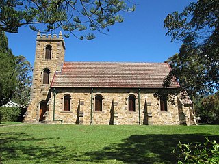
St Stephen's Presbyterian Church is a heritage-listed former Presbyterian church at 2 Allowrie Street, Jamberoo, Municipality of Kiama, New South Wales, Australia. It was designed by John Colley and built in 1875 by John and James Marks, D. L. Dymock and W. Stewart. It was added to the New South Wales State Heritage Register on 2 April 1999. The church building was sold to private interests in 2009.


