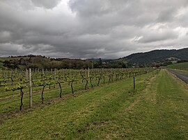
Kiama is a coastal country town 120 kilometres south of Sydney in the Illawarra. One of the main tourist attractions is the Kiama Blowhole. Kiama features several popular surfing beaches and caravan parks, and numerous alfresco cafes and restaurants. Its proximity to the south of Sydney makes it an attractive destination for many day-trippers and weekenders. Kiama also has historically been a farming and agricultural centre. Even to today it maintains a country and agricultural community with a weekly farmers markets held on Wednesday afternoons.

The Illawarra is a coastal region in the southeast of the Australian state of New South Wales. It is situated immediately south of Sydney and north of the South Coast region. It encompasses the two cities of Wollongong, Shellharbour and the coastal town of Kiama. Wollongong is the largest city of the Illawarra with a population of 240,000, then Shellharbour with a population of 70,000 and Kiama with a population of 10,000. These three cities have their own suburbs. Wollongong stretches from Otford in the north to Windang in the south, with Maddens Plains and Cordeaux in the west.

Gerringong is a town located about ten minutes drive south of Kiama, and about twenty minutes north of Nowra in the Illawarra region of New South Wales, Australia in the Municipality of Kiama. At the 2021 census, Gerringong had a population of 4,165. One theory says that the name derives from an Aboriginal word meaning "fearful place".

The South Coast Railway is a commuter and goods railway line from Sydney to Wollongong and Bomaderry in New South Wales, Australia. Beginning at the Illawarra Junction, the line services the Illawarra and South Coast regions of New South Wales.

Gerringong railway station is a single-platform intercity railway station located in Gerringong, New South Wales, Australia, on the South Coast railway line. The station serves NSW TrainLink diesel multiple unit trains travelling south to Bomaderry and north to Kiama. Early morning and late night services to the station are provided by train replacement bus services. In the past, the station precinct also catered to freight trains carrying dairy products.

Kiama railway station is a heritage-listed intercity train station located in Kiama, New South Wales, Australia, on the South Coast railway line. The station serves NSW TrainLink diesel multiple unit trains traveling south to Bomaderry and electric multiple unit trains north to Wollongong and Sydney. Early morning and late night services to and from stations to the south are provided by train replacement bus services. It was added to the New South Wales State Heritage Register on 2 April 1999.

Unanderra railway station is located on the South Coast railway line in the Wollongong suburb of Unanderra, New South Wales, Australia.
Willow Vale is a Northern Village of the Southern Highlands of New South Wales, Australia, in Wingecarribee Shire. It is located 2 km north of Mittagong and is often considered part of Braemar along with its neighbour Balaclava.
Willow Vale or Willowvale may refer to:

Kiama High School is a government-funded co-educational comprehensive secondary day school, located in the town of Kiama, in the Illawarra region of New South Wales, Australia.

The Municipality of Kiama is a local government area in the Illawarra region of New South Wales, Australia. The area is situated south of Shellharbour and the City of Wollongong and is located adjacent to the Pacific Ocean, the Princes Highway and the South Coast railway line.
Willow Vale, New South Wales may refer to:

Foxground is a locality in the Municipality of Kiama, in the Illawarra region of New South Wales, Australia. It is located two kilometres from the Princes Highway, 20 kilometres south west of Kiama. Broughton Creek flows through the valley.

NSW Kiama Fowler is a steam locomotive that was in service in New South Wales, Australia. It is sometimes also called Wollondilly.
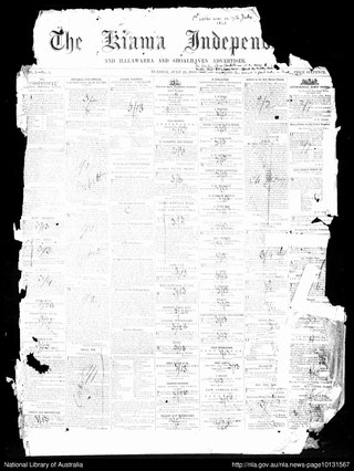
The Kiama Independent and Illawarra and Shoalhaven Advertiser, also published originally as Kiama Examiner, then as The Examiner , was a weekly English language newspaper published in Kiama, New South Wales, Australia. It was also published as The Kiama Independent and Shoalhaven Advertiser and since 1947 as Kiama Independent.

Broughton Village is a locality on the border of the Kiama and Shoalhaven local government areas in New South Wales, Australia. It lies on the Princes Highway about 18 km southwest of Kiama and 39 km north of Nowra and on Broughton Creek. At the 2021 census, it had a population of 95. Broughton Village is to not to be confused with Broughton, a locality that lies to its immediate southwest or Broughton Vale, which lies to its immediate northwest.

Kiama Post Office is a heritage-listed post office at 24 Terralong Street, Kiama, Municipality of Kiama, New South Wales, Australia. It was designed by the Colonial Architect's Office under James Barnet. and built by W. R. Vaughan. The property is owned by Australia Post. It was added to the New South Wales State Heritage Register on 22 December 2000.
Mittagong Shire was a local government area in the Southern Highlands region of New South Wales, Australia.
The Municipality of Broughton's Vale was a municipality of New South Wales that existed from 1871 to 1948.