Nowra

Last updated • 8 min readFrom Wikipedia, The Free Encyclopedia

Nowra
New South Wales
City Administration Centre in Nowra (3).jpg
Nowra City Administration centre
Australia New South Wales relief location map.png
Red pog.svg
Nowra
Nowra
Coordinates 34°53′S150°36′E / 34.883°S 150.600°E / -34.883; 150.600
Population22,584 (2021) [1]
 • Density212.6/km2 (551/sq mi)
Established1852
Postcode(s) 2541
Elevation9 m (30 ft)
Area202.4 km2 (78.1 sq mi)
Time zone AEST (UTC+10)
 • Summer (DST) AEDT (UTC+11)
Location
LGA(s) City of Shoalhaven
State electorate(s) South Coast
Federal division(s) Gilmore
Mean max temp [2] Mean min temp [2] Annual rainfall [2]
22.4 °C
72 °F
11.7 °C
53 °F
1,026.1 mm
40.4 in
Localities around Nowra:
North Nowra Bomaderry Bolong
West Nowra Nowra Terara
Mundamia South Nowra Worrigee

Nowra ( /naʊərə/ ) is a city in the South Coast region of New South Wales, Australia. [3] It is located 160 kilometres (99 mi) south-southwest of the state capital of Sydney (about 120 kilometres (75 mi) as the crow flies). As of the 2021 census, Nowra has an estimated population of 22,584. Situated in the southern reaches of the Sydney basin, [4] Nowra is the seat and commercial centre of the City of Shoalhaven.

Contents

The region around Nowra is a farming community with a thriving dairy industry and a significant amount of state-owned forest land. It is also an increasingly popular retirement and leisure area for people from Canberra and Sydney. The naval air station HMAS Albatross is located about 10 kilometres (6.2 mi) south-west of Nowra.

History

Kinghorn Street in 1930 Kinghorn Street, Nowra, N.S.W. - circa 1930.jpg
Kinghorn Street in 1930

Prior to European arrival, the part of the Nowra region south of the Shoalhaven river was inhabited by the Wandi-Wandandian tribe of the Yuin nation, while the region north of Shoalhaven was inhabited by the Dharawal people.[ citation needed ] The name Nowra, originally written by Europeans as 'nou-woo-ro' (pronounced Nowa Nowa by the Indigenous Australians of the area), is an Aboriginal word for the black cockatoo. [5]

Circa 1824, ex-convict Mary Reibey applied for a land grant in the Burrier area, on the southern side of the Shoalhaven River. The Nowra township was officially recognised in 1852. Less than ten years later, in 1861, a postal service was established. In 1861, the racehorse Archer, which was trained in Nowra by Etienne de Mestre, won the first Melbourne Cup. Nowra was declared a town in 1885 [6] and a city in 1979.

Bundanon Homestead Bundanon Homestead .jpg
Bundanon Homestead

A major landmark in the area is the house Bundanon, which renowned Australian artist Arthur Boyd and his wife Yvonne donated to the people of Australia in 1993 along with an adjoining property that had been previously owned by Boyd's brother-in-law, the equally famous Australian artist Sidney Nolan. [7] [8] Bundanon began as a single-storey weatherboard structure built around 1840. In 1866, a two-storey sandstone house, made of locally quarried stone, was built immediately in front of the original weatherboard house. The sandstone house features timber verandas and is now listed on the Register of the National Estate. [9]

Heritage listings

Nowra has a number of heritage-listed sites, including:

Geography

Along the north of Nowra is the Shoalhaven River, which formerly hosted the Australian National wakeboarding championships and is a popular fishing location. The Nowra Bridge connects it to North Nowra and Bomaderry. The Shoalhaven River is a saltwater river, although it does not flow into the sea. The Shoalhaven River meets the sea through the canal that joins the Shoalhaven and Crookhaven Rivers, which was dug by convicts under the direction of local entrepreneur and pioneer Alexander Berry.

Nowra area from Cambewarra Lookout Cambewarra lookout.jpg
Nowra area from Cambewarra Lookout

Climate

Nowra possesses a humid subtropical climate (Köppen: Cfa), with very warm, wet summers and mild, relatively dry winters. Compared with nearby Wollongong and Kiama which have an oceanic climate, Nowra has slightly warmer summers due to its inland location, thus qualifying it as humid subtropical climate. [12] Average maxima vary from 27.6 °C (81.7 °F) in January to 16.8 °C (62.2 °F) in July, while average minima fluctuate between 16.8 °C (62.2 °F) in January and 6.8 °C (44.2 °F) in July. Annual precipitation is moderately high (averaging 1,026.1 mm (40.40 in)), and is spread across 86.7 precipitation days (over 1.0 mm (0.039 in)). Due to its position on the leeward side of the Great Dividing Range, Nowra experiences a foehn effect, particularly in late winter and spring. [13] The town experiences 99.6 clear days and 127.4 cloudy days per annum. [14] Extreme temperatures have ranged from 45.6 °C (114.1 °F) on 21 December 2019 to −0.9 °C (30.4 °F) on 24 August 2002. [15]

Climate data for Nowra (HMAS Albatross) ( 34°57′S150°32′E / 34.95°S 150.54°E / -34.95; 150.54 , 109 m AMSL) (2000−2024, sun 1965−1997)
MonthJanFebMarAprMayJunJulAugSepOctNovDecYear
Record high °C (°F)45.4
(113.7)
42.8
(109.0)
38.6
(101.5)
34.6
(94.3)
27.4
(81.3)
24.1
(75.4)
26.0
(78.8)
28.1
(82.6)
36.3
(97.3)
37.1
(98.8)
41.4
(106.5)
45.6
(114.1)
45.6
(114.1)
Mean daily maximum °C (°F)27.6
(81.7)
26.4
(79.5)
25.2
(77.4)
22.9
(73.2)
19.7
(67.5)
17.0
(62.6)
16.8
(62.2)
18.4
(65.1)
21.1
(70.0)
23.2
(73.8)
24.7
(76.5)
26.1
(79.0)
22.4
(72.4)
Mean daily minimum °C (°F)16.8
(62.2)
16.7
(62.1)
15.3
(59.5)
12.5
(54.5)
9.4
(48.9)
7.7
(45.9)
6.8
(44.2)
7.0
(44.6)
8.8
(47.8)
10.9
(51.6)
13.5
(56.3)
14.9
(58.8)
11.7
(53.0)
Record low °C (°F)8.6
(47.5)
9.5
(49.1)
7.2
(45.0)
3.7
(38.7)
3.0
(37.4)
1.3
(34.3)
−0.5
(31.1)
−0.9
(30.4)
2.4
(36.3)
2.7
(36.9)
5.7
(42.3)
7.4
(45.3)
−0.9
(30.4)
Average precipitation mm (inches)76.5
(3.01)
138.7
(5.46)
138.2
(5.44)
75.4
(2.97)
58.5
(2.30)
106.3
(4.19)
78.5
(3.09)
74.5
(2.93)
43.1
(1.70)
75.9
(2.99)
87.7
(3.45)
72.2
(2.84)
1,026.1
(40.40)
Average precipitation days (≥ 1.0 mm)8.09.19.57.15.56.85.75.46.27.38.27.986.7
Average afternoon relative humidity (%)57635957555653464752565555
Average dew point °C (°F)15.3
(59.5)
16.2
(61.2)
14.3
(57.7)
11.3
(52.3)
8.2
(46.8)
6.4
(43.5)
4.9
(40.8)
4.1
(39.4)
6.1
(43.0)
8.4
(47.1)
12.5
(54.5)
13.2
(55.8)
10.1
(50.1)
Mean monthly sunshine hours 207.7186.5198.4201.0182.9171.0207.7232.5222.0223.2219.0226.32,478.2
Percent possible sunshine 47495260575867696255525057
Source: Bureau of Meteorology [2] [16]
Historical population
YearPop.±%
19212,202    
19332,978+35.2%
19473,551+19.2%
19545,981+68.4%
19616,221+4.0%
19669,633+54.8%
197112,873+33.6%
197615,496+20.4%
198117,887+15.4%
198619,553+9.3%
199121,942+12.2%
199623,823+8.6%
200124,700+3.7%
200627,478+11.2%
201127,988+1.9%
201630,853+10.2%
202133,583+8.8%
Source: Australian Bureau of Statistics data. [17] [18]

Demographics

Nowra Creek AMudgeeShot0010.jpg
Nowra Creek

According to the 2021 census, Nowra has a population of 22,584. This covers suburbs only south of the Shoalhaven River. [1] The population is slightly younger than the state and country as a whole, with an average age of 37 compared to 38 for both Australia and New South Wales. However, the population is bimodally distributed, with a larger percentage of children and the elderly than the state and national averages. [1] 79.7% of the population were born in Australia and 82.1% speak only English at home, both above the state and national averages. [1]

Nowra has a lower level of tertiary education than typical for the state and nation. Only 15% of the population of Nowra hold a tertiary qualification, compared to 23.3% of Australia and 23.8% of New South Wales. [1]

The top five reported ancestries in Nowra at the 2021 census were Australian (40.9%), English (37.7%), Australian Aboriginal (10%), Irish (9.5%), and Scottish (8.3%). [1] Most (63%) people had both parents born in Australia, higher than the state and national averages.

The population of the suburb of Nowra (central Nowra) at the 2021 census was 9,956. [1] The Australian Bureau of statistics also recognises a larger built-up area including suburbs north of the Shoalhaven, North Nowra-Bomaderry, which had a population of 16,098 at the 2021 census. [1]

Economy

Nowra shops (Junction Street) Nowra shops.jpg
Nowra shops (Junction Street)

Nowra Town Hall was built in 1948 and is in the Central Business District. This district contains many services, including banks, health services and a library.

Shoalhaven Entertainment Centre Shoalhaven Entertainment Centre.jpg
Shoalhaven Entertainment Centre

Nowra has a growing tourist industry, especially in the summer months, when visitors (mostly from Sydney and Canberra) flock to the beaches to enjoy swimming, surfing, fishing, shopping, and relaxing in the restaurants and cafés.

Nowra sits in the Shoalhaven region, where there are several vineyards.

Education

Nowra has three public high schools: Nowra High School, Shoalhaven High School and Bomaderry High School. There are also several non-government schools, three of which are religiously affiliated:

The district also has an independent school of special assistance. The Shoalhaven River College commenced classes in 2019 and enrols 60 students in years 9–12 in the mainstream curriculum.

There are seven public primary schools in the Nowra area: East Nowra Public School, Nowra Public School, Bomaderry Public School, Illaroo Road Public School, North Nowra Public School, Nowra Hill Public School, and Terara Public School.

The University of Wollongong has a campus in Nowra, and there is a campus of TAFE NSW Illawarra Institute in Bomaderry.

Health

There are two hospitals in Nowra: the Shoalhaven District Memorial Hospital, which is a hub for oncology services, and Nowra Private Hospital.

Sports

Marriott Park Nowra park.jpg
Marriott Park

The four major codes of football in Australia are all popular in the Nowra area. Rugby league was traditionally represented by the Nowra Warriors and Bomaderry Swamp Rats, however, at the end of 2007 these teams merged to form the Shoalhaven Jets Rugby League Football Club. Other rugby league teams in the Shoalhaven area include the St Georges Basin Dragons, Culburra Dolphins, Sussex Inlet Panthers and Berry Magpies, all of whom source some of their players from Nowra. All of these clubs compete in the Group 7 Rugby League competition.

Rugby union is represented by the Shoalhaven Rugby Club, who play out of Rugby Park in South Nowra. The club won the 2008 premiership in the Illawarra district competition, and has produced international and provincial players such as Andrew Walker and Alex Kanaar.

Australian rules football is played by two clubs from the Shoalhaven area, with the Bomaderry Tigers playing at Artie Smith Oval. Further south, the Bay and Basin Bombers play at the Leisure Centre at Vincentia. These two clubs are both members of the South Coast AFL, fielding junior and senior teams.

The Shoalhaven Mariners were established in 2006 and represent the area in the sport of baseball. The team plays home matches out of Fred Finch Park in Berkeley, Wollongong. Baseball has a new venue at the South Nowra Soccer Complex. [19] The Shoalhaven Tigers represent the area in the New South Wales State Basketball League and have won several championships from 1988 until 2007.

Archer was an Australian thoroughbred racehorse trained in the Nowra area who won the first and the second Melbourne Cups in 1861 and 1862. He won both Cups by a significant margin. Archer is one of only five horses to have won the Melbourne Cup on two or more occasions, and one of only four horses to have won two successive Cups.

Public transport

Nowra Bridge Nowra Bridge.jpg
Nowra Bridge

Nowra Coaches operates services from Nowra to Bomaderry, Huskisson, Vincentia and Jervis Bay. [20] Shoal Bus operates services from Nowra to Berry, Gerringong and Sussex Inlet. [21] Premier Motor Service operates express services along the Princes Highway from Sydney to Eden that call at Nowra. [22]

Nowra has no direct rail connection, but the Illawarra railway line terminates at nearby Bomaderry railway station with NSW TrainLink operating services to Kiama and Sydney. [23]

Notable people

Attractions

Related Research Articles

<span class="mw-page-title-main">City of Shoalhaven</span> Local government in New South Wales, Australia

The City of Shoalhaven is a local government area in the South Coast region of New South Wales, Australia. The area is about 200 kilometres (120 mi) south of Sydney. The Princes Highway passes through the area, and the South Coast railway line traverses the northern section, terminating at Bomaderry. At the 2021 census, the population was 108,531.

<span class="mw-page-title-main">Milton, New South Wales</span> Town in New South Wales, Australia

Milton is a village in the South Coast region of New South Wales, Australia, within the City of Shoalhaven. It was founded in 1860, named after the property of post master George Knight and became an important regional centre during the 19th Century. Today, Milton remains one of the two main commercial centres of the Milton-Ulladulla district, with a population at the 2016 census of 1,663. It is a popular stopping place for travellers on the Princes Highway which runs through the centre of town. In recent years, Milton has undergone a resurgence largely influenced by the local tourism industry and an influx of residents to the district seeking a seachange. Several new housing estates are being developed on the fringes of the village and new boutique stores, cafes and bed and breakfast type businesses have located in the town.

Berry is a small Australian village in the Shoalhaven region of the New South Wales South Coast, located 143 km (89 mi) south of the state capital, Sydney. It has many historical buildings which are listed on the New South Wales Heritage Register. Berry attracts many tourists who come to enjoy the diversity of landscapes, including coastal beaches, rich dairy farming, and forested mountains. The village hosts a local Produce Market which is held twice each month on the second Saturday and fourth Sunday. Together with Kiama 23 km (14 mi) to the north, Berry acts as a gateway through to other towns and villages along the South Coast of NSW via the Princes Highway and the South Coast railway line. Major highway building projects in and around Berry have now bypassed the village, creating uninterrupted motorway conditions for coastal travel south to Nowra and the South Coast and north to Wollongong and Sydney. This has resulted in the removal of all but local and visitor traffic within the village. Planning is underway to create a pedestrian-friendly precinct in and around Queens Street.

<span class="mw-page-title-main">Kiama, New South Wales</span> Town in New South Wales, Australia

Kiama is a coastal town 120 kilometres south of Sydney in the Illawarra region of New South Wales. One of the main tourist attractions is the Kiama Blowhole. Kiama features several popular surfing beaches and caravan parks, and numerous alfresco cafes and restaurants. Its proximity to the south of Sydney makes it an attractive destination for many day-trippers and weekenders. Kiama also has historically been a farming and agricultural centre. Even to today it maintains a country and agricultural community with a weekly farmers markets held on Wednesday afternoons.

<span class="mw-page-title-main">Taree</span> City in New South Wales, Australia

Taree is a city on the Mid North Coast, New South Wales, Australia. It and nearby Cundletown were settled in 1831 by William Wynter. Since then it has grown to a population of 26,381, and commands a significant agricultural district. Situated on a floodplain by the Manning River, it is 16 km from the Tasman Sea coast, and 317 km north of Sydney.

<span class="mw-page-title-main">Cooma</span> Town in New South Wales, Australia

Cooma is a town in the south of New South Wales, Australia. It is located 114 kilometres (71 mi) south of the national capital, Canberra, via the Monaro Highway. It is also on the Snowy Mountains Highway, connecting Bega with the Riverina.

<span class="mw-page-title-main">Bomaderry, New South Wales</span> Suburb of Shoalhaven, New South Wales, Australia

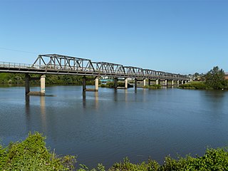
Bomaderry is a suburb in the City of Shoalhaven local government area in New South Wales, Australia. At the 2021 census, it had a population of 8,718 people. It is on the north shore of the Shoalhaven River, across the river from Nowra, the major town of the City of Shoalhaven, of which Bomaderry is locally regarded as being a suburb of the city.

<span class="mw-page-title-main">Shoalhaven River</span> River in Australia

The Shoalhaven River is a perennial river that rises from the Southern Tablelands and flows into an open mature wave dominated barrier estuary near Nowra on the South Coast of New South Wales, Australia.

<span class="mw-page-title-main">Casino, New South Wales</span> Town in New South Wales, Australia

Casino is a town in the Northern Rivers area of New South Wales, Australia, with a population of 12,298 people at the 2021 census. It lies on the banks of the Richmond River and is situated at the junction of the Bruxner Highway and the Summerland Way.

<span class="mw-page-title-main">Gerringong, New South Wales</span> Town in New South Wales, Australia

Gerringong is a town located about ten minutes drive south of Kiama, and about twenty minutes north of Nowra in the Illawarra region of New South Wales, Australia in the Municipality of Kiama. At the 2021 census, Gerringong had a population of 4,165. One theory says that the name derives from an Aboriginal word meaning "fearful place".

<span class="mw-page-title-main">Kangaroo Valley, New South Wales</span> Suburb of City of Shoalhaven, New South Wales, Australia

Kangaroo Valley is a river valley along the Kangaroo River in the Shoalhaven region of New South Wales, Australia, located west of the seaside in the City of Shoalhaven. It is also the name of the small suburb within it, formerly known as Osborne, with a population of 879 in the 2016 census. The township is accessed by the Moss Vale Road, which links Moss Vale to the Princes Highway at Bomaderry a little north of Nowra via the B73 route.

<span class="mw-page-title-main">Bowral</span> Town in New South Wales, Australia

Bowral is the largest town in the Southern Highlands of New South Wales, Australia, about ninety minutes southwest of Sydney. It is the main business and entertainment precinct of the Wingecarribee Shire and Highlands.

<span class="mw-page-title-main">Moss Vale</span> Town in New South Wales, Australia

Moss Vale is a town in the Southern Highlands of New South Wales, Australia, in the Wingecarribee Shire. It is located on the Illawarra Highway, which connects to Wollongong and the Illawarra coast via Macquarie Pass.

<span class="mw-page-title-main">South Coast (New South Wales)</span> Region in New South Wales, Australia

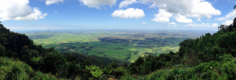
The South Coast refers to the narrow coastal belt from the Shoalhaven district in the north to the state border with Victoria in the south in the south-eastern part of the State of New South Wales, Australia. It is bordered to the west by the coastal escarpment of the Southern Tablelands, and is largely covered by a series of national parks, namely Jervis Bay National Park, Eurobodalla National Park, and Beowa National Park. To the east is the coastline of the Pacific Ocean, which is characterised by rolling farmlands, small towns and villages along a rocky coastline, interspersed by numerous beaches and lakes.

<span class="mw-page-title-main">Helensburgh, New South Wales</span> Suburb of Sydney, New South Wales, Australia

Helensburgh is a small town, located 45 kilometres (28 mi) south of Sydney and 35 kilometres (22 mi) north of Wollongong and north and above the Illawarra escarpment and region. Helensburgh is in the Wollongong City Council local government area. It is surrounded by bushland reserves adjacent to the southern end of the Royal National Park and Garawarra State Conservation Area and the Woronora reservoir water catchment is to its west.

<span class="mw-page-title-main">Group 7 Rugby League</span>

South Coast Group 7 Rugby League is the divisional boundary drawn from the Southern Illawarra and South Coast regions of New South Wales, Australia and is governed by the NSWCRL. The main semi-professional competition,, comprises ten (10) teams from across the region. Group 7 Rugby League also administers reserve grade, third grade, and under-18s competitions, Ladies League Tag, as well as looking over many junior competitions.

<span class="mw-page-title-main">AFL South Coast</span>

The AFL South Coast is an Australian rules football competition in the Shoalhaven and Illawarra regions of New South Wales. The AFLSC has two divisions of senior men's football and one division of senior women's football. In 2012 The South Coast AFL became "AFL South Coast" incorporating the three leagues of South Coast AFL Seniors, Shoalhaven Juniors and Illawarra Juniors.

In the state of New South Wales, Australia, there are many areas which are commonly known by regional names. Regions are areas that share similar characteristics. These characteristics may be natural such as the Murray River, the coastline, or the Snowy Mountains. Alternatively, the characteristics may be cultural, such as a viticulture land use. New South Wales is divided by numerous regional boundaries, based on different characteristics. In many cases boundaries defined by different agencies are coterminous.

<span class="mw-page-title-main">Tomerong</span> Town in New South Wales, Australia

Tomerong is a village in the South Coast region of New South Wales, Australia. It is located approximately 180 kilometres by road south from the state capital Sydney and 20 kilometres south of the commercial centre of the City of Shoalhaven, Nowra in the County of St Vincent. The village is eight kilometres inland of the western shores of Jervis Bay and is located at the boundary of the Parish of Tomerong and the Parish of Wandrawandian. Its population at the 2021 census was 1,194. The traditional custodians of this country are the Wandandian people of Yuin Country who spoke the Dhurga language.

<span class="mw-page-title-main">Premier Transport Group</span> Australian commercial intercity bus company

Premier Transport Group is an Australian operator of bus and coach services in New South Wales and Queensland. Its origins can be traced back to December 1987 when John King purchased Nowra Coaches. It has since expanded through a number of acquisitions.

References

  1. 1 2 3 4 5 6 7 8 "2021 Census QuickStat: Nowra (Statistical Area Level 2)". Australian Bureau of Statistics. Retrieved 31 July 2022.
  2. 1 2 3 4 "Nowra Ran Air Station AWS Climate Statistics (2000-2024)". Bureau of Meteorology . Retrieved 22 September 2024.
  3. "Nowra-Bomaderry | New South Wales, Australia | Britannica".
  4. GIF map. dpi.nsw.gov.au
  5. "Travel: Nowra", Sydney Morning Herald , 8 February 2004. Retrieved 26 April 2007.
  6. "Nowra Police Station Archived 6 March 2011 at the Wayback Machine ". NSW Police Regions and History. Retrieved 29 April 2008
  7. Morris, Linda (29 June 2018). "Future of Arthur Boyd's gift to the nation is secured". The Sydney Morning Herald. Retrieved 12 January 2021.
  8. "Picasso, Boyd, Nolan artworks in multi-million-dollar move as fire threat makes them 'too vulnerable'". www.abc.net.au. 16 January 2020. Retrieved 12 January 2021.
  9. The Heritage of Australia, Macmillan Company, 1981, p.2/162
  10. "Graham Lodge". New South Wales State Heritage Register . Department of Planning & Environment. H01699. Retrieved 18 May 2018. CC BY icon.svg Text is licensed by State of New South Wales (Department of Planning and Environment) under CC BY 4.0 licence .
  11. "Meroogal". New South Wales State Heritage Register . Department of Planning & Environment. H00953. Retrieved 18 May 2018. CC BY icon.svg Text is licensed by State of New South Wales (Department of Planning and Environment) under CC BY 4.0 licence .
  12. Stern, H., de Hoedt, G. and Ernst, J. 2000. Objective Classification of Australian Climates. Bureau of Meteorology, Melbourne.
  13. Rain Shadows by Don White. Australian Weather News. Willy Weather. Retrieved 24 May 2021.
  14. "Nowra Ran Air Station Climate (1955-2000)". FarmOnline Weather. Retrieved 22 September 2024.
  15. "Nowra Ran Air Station AWS Climate (2000-2024)". FarmOnline Weather. Retrieved 22 September 2024.
  16. "Nowra Ran Air Station Climate Statistics (1955-2000)". Bureau of Meteorology . Retrieved 22 September 2024.
  17. "Statistics by Catalogue Number". Australian Bureau of Statistics. Retrieved 15 May 2024.
  18. "Search Census data". Australian Bureau of Statistics. Retrieved 15 May 2024. Note: counts urban area of Nowra-Bomaderry
  19. http://www.southcoastregister.com.au/news/local/sport/baseball/mariners-start-preseason-training/1774804.aspx Mariners start pre-season training. South Coast Register (11 March 2010). Retrieved 2 January 2016.
  20. Home Nowra Coaches
  21. Timetables Shoal Bus
  22. Sydney to Eden Premier Motor Service
  23. South Coast Line Transport for NSW