
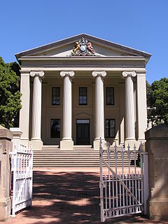
New South Wales is a state on the east coast of Australia. It borders Queensland to the north, Victoria to the south, and South Australia to the west. Its coast borders the Coral and Tasman Seas to the east. The Australian Capital Territory and Jervis Bay Territory are enclaves within the state. New South Wales' state capital is Sydney, which is also Australia's most populous city. In December 2021, the population of New South Wales was over 8 million, making it Australia's most populous state. Just under two-thirds of the state's population, 5.3 million, live in the Greater Sydney area.
Young is a town in the South West Slopes region of New South Wales, Australia and the largest town in the Hilltops Region. The "Lambing Flat" Post Office opened on 1 March 1861 and was renamed "Young" in 1863.

Bundanoon is a town in the Southern Highlands of New South Wales, Australia, in Wingecarribee Shire, on Gandangarra and Dharawal Country. It is an Aboriginal name meaning "place of deep gullies" and was formerly known as Jordan's Crossing. Bundanoon is colloquially known as Bundy/Bundi.
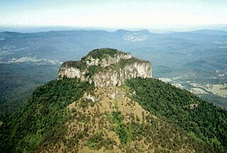
Mount Lindesay is a rural locality in the Scenic Rim Region, Queensland, Australia. It borders New South Wales. In the 2016 census, Mount Lindesay had a population of 3 people.
Dalgety is a small town in New South Wales, Australia, on the banks of the Snowy River between Melbourne and Sydney.
Medowie is a suburb of the Port Stephens local government area in the Hunter Region of New South Wales, Australia. It is located approximately 34 km (21 mi) by road north of Newcastle, not far from RAAF Base Williamtown and is home to many of the personnel stationed there. The Worimi people are the traditional owners of the Port Stephens area.

Salamander Bay is a suburb of the Port Stephens local government area in the Hunter Region of New South Wales, Australia. The Worimi people are the traditional owners of the Port Stephens area. Named after the adjacent shallow bay, itself named after Salamander, a convict ship from the Third Fleet, which was the first European vessel to enter Port Stephens (1791), it is a mainly residential suburb with a large shopping centre. At the 2021 census, Salamander Bay had a population of 4,991. It is home to Tomaree High School, a TAFE facility and St Phillips Christian College.
Lockhart is a town in the Riverina Region of New South Wales, Australia. It is the location of the Lockhart Shire Council offices. At the 2016 census, Lockhart had a population of 818 people.
Bathurst Regional Council is a local government area in the Central West region of New South Wales, Australia. The area is located adjacent to the Great Western Highway, Mid-Western Highway, Mitchell Highway and the Main Western railway line. At the 2016 census, the Bathurst Region had a population of 41,300.

Jugiong is a locality and town on the banks of the Murrumbidgee River near its confluence with Jugiong Creek. in the Hilltops Council Local Government area, New South Wales, Australia. It is situated just off the Hume Highway, by road, about 30 kilometres southwest from Bookham and 40 kilometres northeast from Gundagai.
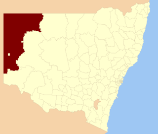
The Unincorporated Far West Region is an unincorporated area in the Far West region of New South Wales, Australia. The area is one of only two areas in New South Wales that are not part of any local government area. The region includes several small towns including Tibooburra, Milparinka and Silverton. Silverton and Tibooburra have village councils. The region surrounds Broken Hill, but does not include it, which is in the separate City of Broken Hill local government area.
Wildes Meadow is a locality in the Southern Highlands of New South Wales, Australia, in Wingecarribee Shire.

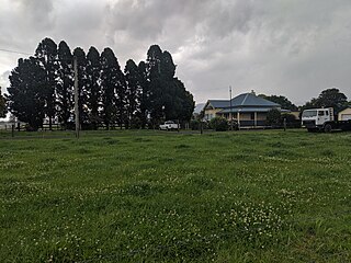
Brayton is a locality in the Southern Tablelands of New South Wales, Australia, in the Upper Lachlan Shire. At the 2021 census, it had a population of 208.
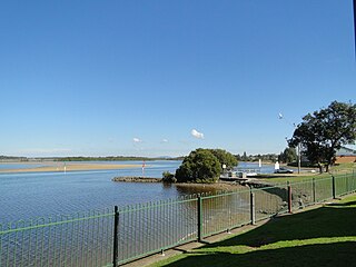
Harrington is a small village located on the northern entrance of the Manning River in New South Wales, Australia. It was established in 1853 and proclaimed a village on 26 September 1896. It is 15 km north-east of Taree on the Mid North Coast, and 335 kilometres (208 mi) north east of the state capital, Sydney. At the 2021 census, Harrington had a population of 3,381. It was named after the Earl of Harrington by the explorer, John Oxley.

East Seaham is a primarily rural suburb of the Port Stephens local government area in the Hunter Region of New South Wales, Australia. It is situated on the east bank of the Williams River, opposite Glen Oak and Seaham. At the 2011 census, the population of East Seaham and the adjacent suburb of Balickera was 359, with the two suburbs having an average population density of 5.5/km2 (14/sq mi).
Nubba is a locality and former railway station on the Main South railway line in New South Wales, Australia, located midway between Wallendbeen and Harden. The station was open between 1882 and 1975 and has now been demolished.
Bribbaree is a small village in the South West Slopes region of New South Wales, Australia spanning the boundary of Weddin Shire and Hilltops Council.

Merricumbene is a locality in the Eurobodalla Shire, New South Wales, Australia. It is located about 43 km south of Braidwood and 40 km northwest of Moruya in the valley of the Deua River. At the 2016 census, it had a population of 19.
Bolong is a locality in the City of Shoalhaven in New South Wales, Australia. It lies to the north of the Shoalhaven River and to the west of Broughton Creek. It is northeast of Nowra. At the 2016 census, it had a population of 104.
Meadow Flat is a locality in the Bathurst Region and City of Lithgow of New South Wales, Australia. It had a population of 309 people as of the 2016 census.

