
The City of Shoalhaven is a local government area in the south-eastern coastal region of New South Wales, Australia. The area is about 200 kilometres (120 mi) south of Sydney. The Princes Highway passes through the area, and the South Coast railway line traverses the northern section, terminating at Bomaderry. At the 2021 census, the population was 108,531.

Jervis Bay is a 102-square-kilometre (39 sq mi) oceanic bay and village on the south coast of New South Wales, Australia, said to possess the whitest sand in the world.

Nowra is a city in the South Coast region of New South Wales, Australia. It is located 160 kilometres (99 mi) south-southwest of the state capital of Sydney. As of the 2021 census, Nowra has an estimated population of 22,584. Situated in the southern reaches of the Sydney basin, Nowra is the seat and commercial centre of the City of Shoalhaven.
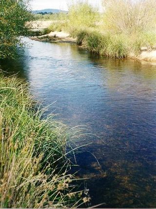
The Shoalhaven River is a perennial river that rises from the Southern Tablelands and flows into an open mature wave dominated barrier estuary near Nowra on the South Coast of New South Wales, Australia.

Huskisson is a town in New South Wales, Australia in the City of Shoalhaven, on the shores of Jervis Bay. It is 24 km south-east of Nowra.

Kangaroo Valley is a river valley along the Kangaroo River in the Shoalhaven region of New South Wales, Australia, located west of the seaside in the City of Shoalhaven. It is also the name of the small suburb within it, formerly known as Osborne, with a population of 879 in the 2016 census. The township is accessed by the Moss Vale Road, which links Moss Vale to the Princes Highway at Bomaderry a little north of Nowra via the B73 route.
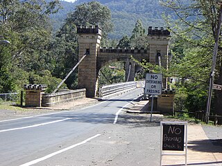
Hampden Bridge is a heritage-listed single-span suspension bridge that carries Moss Vale Road (B73) across the Kangaroo River, in Kangaroo Valley, in the City of Shoalhaven local government area of New South Wales, Australia. The bridge was designed by Ernest de Burgh and built by Loveridge and Hudson. The property is owned by Transport for NSW. It was added to the New South Wales State Heritage Register on 2 August 2019.

The South Coast refers to the narrow coastal belt from Shoalhaven district in the north to the border with Victoria in the south in the south-eastern part of the State of New South Wales, Australia. It is bordered to the west by the coastal escarpment of the Southern Tablelands, and is largely covered by a series of national parks, namely Jervis Bay National Park, Eurobodalla National Park, and Beowa National Park. To the east is the coastline of the Pacific Ocean, which is characterised by rolling farmlands, small towns and villages along a rocky coastline, interspersed by numerous beaches and lakes.
Avoca is a small town in the Southern Highlands of New South Wales, Australia, in Wingecarribee Shire.
Upper Kangaroo River is a small village in the Southern Highlands of New South Wales, Australia, in Shoalhaven City Council. It is located on the Kangaroo River, a tributary of the Shoalhaven River. At the 2021 census, it had a population of 151.

The AFL South Coast is an Australian rules football competition in the Shoalhaven and Illawarra regions of New South Wales. The AFLSC has three divisions of senior men's football and two divisions of senior women's football. In 2012 The South Coast AFL became "AFL South Coast" incorporating the three leagues of South Coast AFL Seniors, Shoalhaven Juniors and Illawarra Juniors.
St Michael's, Nowra, is a parish of the Roman Catholic Diocese of Wollongong in Australia. The parish takes in the northern Shoalhaven City region. It incorporates the Church Communities of St Michael, Nowra; St Patrick, Berry, Sacred Heart, Bomaderry; Mary, Help of Christians, Culburra; St Joseph, Kangaroo Valley; and Holy Spirit, Vincentia.
Tomerong is a village in the South Coast region of New South Wales, Australia. It is located approximately 180 kilometres by road south from the state capital Sydney and 20 kilometres south of the commercial centre of the City of Shoalhaven, Nowra in the County of St Vincent. The village is eight kilometres inland of the western shores of Jervis Bay. Its population at the 2021 census was 1,194.
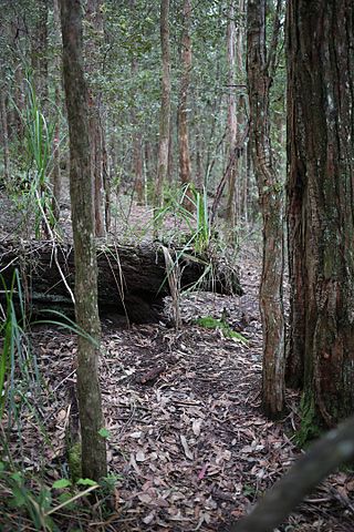
The Kangaroo River Nature Reserve, part of the Kangaroo Valley Group of Nature Reserves, is a protected nature reserve that is located on the floor of the Kangaroo Valley in the Southern Highlands and South Coast regions of New South Wales in eastern Australia. The reserve is situated approximately 150 kilometres (93 mi) south of Sydney, 50 kilometres (31 mi) southwest of Wollongong and 16 kilometres (9.9 mi) northwest of Nowra. The reserve has a protective covenant placed upon it with purpose to ensure the protection of the natural heritage of this area. National parks in the area include the Morton National Park and the Budderoo National Park. Other nature reserves in the area include the Barren Grounds Nature Reserve, and the Cambewarra Range, Barrengarry and Rodway nature reserves – the latter three part of the Kangaroo Valley Group of Nature Reserves.
The Cambewarra Range Nature Reserve, as part of the Kangaroo Valley Group of Nature Reserves, is a protected area located on the cliffs and plateaus of the Kangaroo Valley in the Southern Highlands and South Coast regions of New South Wales in eastern Australia. The Reserve is situated approximately 150 kilometres (93 mi) south of Sydney, 50 kilometres (31 mi) southwest of Wollongong and 16 kilometres (9.9 mi) northwest of Nowra. The Reserve has a total area of 1684 hectares, and includes 11 privately owned properties. It is critical for it to be pristine for a variety of reasons, not the least the catchment of water, as the Reserve floor flows into the Kangaroo Valley River and the Shoalhaven River, from which the Sydney Water Authority draws water to supply large populations in Sydney and Wollongong.

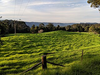
Beaumont is a locality in the City of Shoalhaven in New South Wales, Australia. It lies on Cambewarra Range about 18 km north of Nowra on both sides of the Kangaroo Valley–Nowra road. It includes the Cambewarra Mountain lookout, which gives a good view of the lower Shoalhaven valley. At the 2016 census, it had a population of 125.

Cambewarra Village is a locality in the City of Shoalhaven in New South Wales, Australia. It lies on Main Road, which runs west from Cambewarra Road, which forms part of the Kangaroo Valley–Nowra road, about 9 km northwest of Nowra and south of Cambewarra Mountain. At the 2016 census, it had a population of 1,189. Cambewarra Village is largely surrounded by the locality of Cambewarra.

Berry Mountain is a locality in the City of Shoalhaven in New South Wales, Australia. It lies west of the Princes Highway on the Kangaroo Valley Road between Berry and Kangaroo Valley. It lies about 23 kilometre north of Nowra and about 160 km south of Sydney. At the 2016 census, it had a population of 28. It lies on a ridge and is partly covered by temperate rain forest and partly by grasslands that were formerly used for dairying, but are now mainly used for rural residences.
Bellawongarah is a locality in the City of Shoalhaven in New South Wales, Australia. It lies west of the Princes Highway on the Kangaroo Valley Road between Berry and Kangaroo Valley. It lies about 23 kilometre north of Nowra and about 160 km south of Sydney. At the 2016 census, it had a population of 127. It lies on a ridge and is partly covered by temperate rain forest and partly by grasslands that were formerly used for dairying, but are now mainly used for rural residences.
Cambewarra Shire was a local government area in the South Coast region of New South Wales, Australia.
