
Braidwood is a town in the Southern Tablelands of New South Wales, Australia, in Queanbeyan–Palerang Regional Council. It is located on the Kings Highway linking Canberra with Batemans Bay. It is approximately 200 kilometres south west of Sydney, 60 kilometres inland from the coast, and 55 kilometres east of Canberra. Braidwood is a service town for the surrounding district which is based on sheep and cattle grazing, and forestry operations.
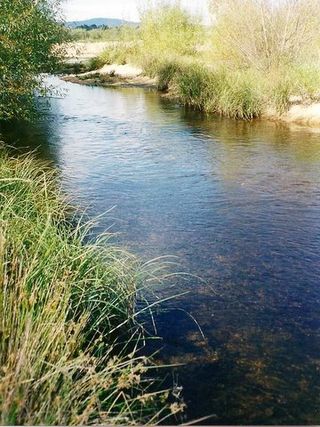
The Shoalhaven River is a perennial river that rises from the Southern Tablelands and flows into an open mature wave dominated barrier estuary near Nowra on the South Coast of New South Wales, Australia.

The Budawang Range, commonly called The Budawangs, a rugged mountain range within the Budawang National Park and the Morton National Park, are part of a spur off the Great Dividing Range and are located in the South Coast region of New South Wales, Australia.

Nerriga is a small village in the Southern Tablelands of New South Wales, Australia in Queanbeyan-Palerang Regional Council. It is situated at the edge of Morton National Park, on the Braidwood - Nowra road. The population of Nerriga and the surrounding localities at the 2016 census was 72.

Vincentia is a town in New South Wales, Australia in the City of Shoalhaven, on the shores of Jervis Bay. It is roughly 25 kilometres (16 mi) southeast of Nowra, and approximately 200 kilometres (120 mi) south of Sydney. At the 2016 census, the population of Vincentia was 3,290. It is also a tourist spot with a beach area featuring white sand and a number of motels.
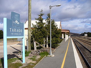
Tarago is a town in the Southern Tablelands of New South Wales, Australia in Goulburn Mulwaree Council. Part of the defined locality, which includes a large area of grazing country, is on the eastern shore of Lake George in the area of the Queanbeyan–Palerang Regional Council. The town is situated 39 kilometres south of the city of Goulburn and 69 kilometres northeast of Canberra, the capital city of Australia. It is located on the Goulburn-Braidwood road. The town is notable for recent renewable energy projects in the surrounding districts.

John Coghill (1785–1853) was an Australian politician and naval captain.

Oallen is a locality in the Goulburn Mulwaree Council area, New South Wales, Australia. It is located on the Shoalhaven River and the Oallen Ford Road about 61 km southeast of Goulburn and 82 km southwest of Nowra. The Oallen Ford Road has recently been upgraded to improve the connection from Canberra and Goulburn to Nerriga, Nowra and Jervis Bay. At the 2016 census, Oallen had a population of 141.

Lower Boro is a locality in the Goulburn Mulwaree Council area, New South Wales, Australia. It is located about 16 km southeast of Tarago. The link from Tarago to Windellama, which is part of a link from Canberra to Nerriga and Nowra, passes through the northern part of the locality. At the 2016 census, Lower Boro had a population of 176.
Tomboye is a locality in the Queanbeyan–Palerang Regional Council, New South Wales, Australia. It is located on the north side of the Mongarlowe River on the road from Braidwood to Nowra about 28 km north of Braidwood and 93 km southwest of Nowra. At the 2016 census, it had a population of 40. It consists mainly of forest and grazing country.

Wog Wog is a locality in the Queanbeyan–Palerang Regional Council, New South Wales, Australia. It is located on the south side of the Corang River and to the east of the road from Braidwood to Nowra about 34 km north of Braidwood and 96 km southwest of Nowra. At the 2016 census, it had a population of 15. It consists mainly of forest, including parts of the Morton National Park. Its eastern boundary runs along the Budawang Range and includes Wog Wog Mountain and Corang Peak.

Corang is a locality in the Queanbeyan–Palerang Regional Council, New South Wales, Australia. It is located on the north side of the Corang River and to the east of the road from Braidwood to Nowra about 46 km north of Braidwood and 75 km southwest of Nowra. At the 2016 census, it had a population of 13. It consists mainly of forest and most of it lies in the Morton National Park. Its eastern boundary runs along the Budawang Range and includes Mount Tarn, Sturgiss Mountain and Quiltys Mountain.
Coolumburra is a locality in the City of Shoalhaven in New South Wales, Australia. It lies on the Braidwood Road on the Endrick River between Nowra and Nerriga. This road continues southwest to Braidwood, but this involves a section of unsealed road. The sealed Oallen Ford Road branches off south of Nerriga, which connects via various sealed roads to Canberra and Goulburn. Coolumburra is heavily forested and part lies within the Morton National Park. At the 2016 census, it had a population of none.
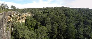
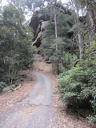
Tianjara is a locality in the City of Shoalhaven in New South Wales, Australia. It lies generally south of the Braidwood Road between Nowra and Nerriga. It is about 47 kilometres southwest of Nowra. Tianjara is fairly rugged sandstone country and largely consists of forest. Most of it lies within the Morton National Park or state forests.

Jerrawangala is a locality in the City of Shoalhaven in New South Wales, Australia. It consists of a small settlement on the Princes Highway south of Nowra and a large unpopulated area to the northwest that lies on both sides of the Braidwood Road between Nowra and Nerriga. It is about 35 kilometres south of Nowra and about 205 km south of Sydney. Jerrawangala is fairly rugged sandstone country and largely consists of forest. Much of it lies within the Jerrawangala National Park or state forests. Jerrawangala lookout is located to the east of the Braidwood Road. At the 2016 census, it had a population of 70.
The Wool Road was a historic road in New South Wales, Australia, that ran from Nerriga to what is now called Vincentia on Jervis Bay. It was constructed privately in 1841, using convict labour. Its purpose was to provide a shorter route to a seaport for wool grown at Braidwood and beyond. The historical significance of The Wool Road is that it was the first road, capable of being used by wheeled vehicles, linking the inland area around Braidwood to the South Coast. The road led to the foundation of the privately owned port town of South Huskisson and the adjacent 'government townshIp' of Huskisson.

Yerriyong is a locality in the City of Shoalhaven in New South Wales, Australia. It lies about 17 km to the southwest of Nowra on the road to Nerriga and Canberra. It is largely made up of eucalyptus forest. At the 2016 census, it had a population of 25.

James Larmer was a government surveyor in the colony of New South Wales. Between 1830 and 1859, he surveyed land, roads and settlements in New South Wales. He was an Assistant Surveyor to the Surveyor-General, Sir Thomas Mitchell, from 1835 to 1855. In 1835, he was second in command of Mitchell’s second expedition. He is also noteworthy for his recording of Aboriginal words from various parts of New South Wales.
William Ryrie (1805—1856) was a Scottish-born Australian pastoralist and pioneer settler colonist of the Braidwood district of New South Wales and the Port Phillip District.
Lieutenant Colonel John Kenneth Mackenzie (1791–1857)—also spelt 'McKenzie' or 'MacKenzie'—was a military officer who fought in the Peninsula War and the War of 1812, and a pioneer colonial settler of New South Wales, Australia. He is a particularly associated with Nerriga, Braidwood and The Wool Road, but also with Dandelong, in the Monaro region.

