
Manly Council was a local government area on the northern beaches region of Sydney, New South Wales, Australia, first incorporated in 1877. On 12 May 2016, the Minister for Local Government announced that Manly Council would be subsumed into the newly formed Northern Beaches Council. The last Mayor of Manly Council was Cr. Jean Hay, a member of the Liberal Party.
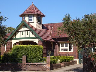
Burwood Heights is a suburb in the Inner West of Sydney, in the state of New South Wales, Australia. It is located 10 kilometres west of the Sydney central business district and is situated within the local government area of Municipality of Burwood.

Wrights Beach is a town in the City of Shoalhaven in New South Wales, Australia. It is on the shores of St Georges Basin, near the Jervis Bay Territory.
St Georges Basin is a town in the South Coast region of New South Wales, Australia. St George Basin is located on the shores of St Georges Basin, within the City of Shoalhaven. It is roughly 25 kilometres (16 mi) south of Nowra, and approximately 200 kilometres (120 mi) south of Sydney.
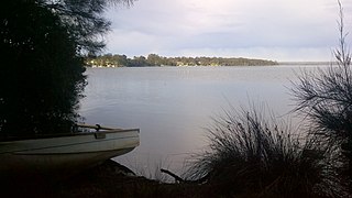
Basin View is a town in New South Wales, Australia in the City of Shoalhaven, on the shores of St Georges Basin. It is roughly 25 km south of Nowra, and approximately 200 km south of Sydney. At the 2016 census, the population of Basin View was 1,554.
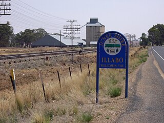
Illabo is a locality in the South West Slopes part of the Riverina in New South Wales, Australia. It is situated about 13 kilometres (8 mi) southwest of Bethungra and 16 kilometres (10 mi) northeast of Junee. At the 2016 census, Illabo had a population of 144.
Upper Kangaroo River is a small village in the Southern Highlands of New South Wales, Australia, in Shoalhaven City Council. It is located on the Kangaroo River, a tributary of the Shoalhaven River. At the 2016 census, it had a population of 122.
Erowal Bay is a small town in the Shoalhaven local government area on the New South Wales south coast, on the northern side of St Georges Basin. It lies west of Hyams Beach and east of Old Erowal Bay. At the 2016 census, Erowal Bay had a population of 623.
Morning Bay is a suburb and adjoining bay in northern Sydney, in the state of New South Wales, Australia. Morning Bay is located 40 kilometres north of the Sydney central business district, in the local government area of Northern Beaches Council.

Greenwell Point is a town in the Shoalhaven region of New South Wales, Australia. It is about 13 km east of Nowra on the South Coast. In the 2016 census of Population and Housing, the town had a population of 1,209.
Lake Heights is a coastal suburb east of Berkeley and south of Cringila in the City of Wollongong. At the 2016 census, it had a population of 3,845.
Gillieston Heights is a suburb of the City of Maitland local government area in the Hunter Region of New South Wales, Australia, approximately 5.1 km (3.2 mi) from the Maitland CBD. Prior to 1967, the village was named East Greta however this was changed to honour former Maitland mayor and member of the New South Wales Legislative Assembly John Gillies following a poll of residents. At the 2016 census, Gillieston Heights had a population of over 3,000.
Kiama Heights is a semi-rural locality in the Illawarra, south of Kiama in New South Wales, Australia. It is located on the coast of the Tasman Sea on either side of the Princes Highway. At the 2016 census, it had a population of 814.

Broughton Village is a locality on the border of the Kiama and Shoalhaven local government areas in New South Wales, Australia. It lies on the Princes Highway about 18 southwest of Kiama and 39 km north of Nowra and on Broughton creek. At the 2016 census, it had a population of 86. Broughton Village is to not to be confused with Broughton, a locality that lies to its immediate southwest or Broughton Vale, which lies to its immediate northwest.

Beaumont is a locality in the City of Shoalhaven in New South Wales, Australia. It lies on Cambewarra Range about 18 km north of Nowra on both sides of the Kangaroo Valley–Nowra road. It includes the Cambewarra Mountain lookout, which gives a good view of the lower Shoalhaven valley. At the 2016 census, it had a population of 125.

Cambewarra is located in New South Wales, Australia. It lies on the Kangaroo Valley–Nowra road, about 11 km northwest of Nowra and south of Cambewarra Mountain. At the 2016 census, it had a population of 238. Cambewarra is a largely rural area, which surrounds Cambewarra Village.

Cambewarra Village is a locality in the City of Shoalhaven in New South Wales, Australia. It lies on Main Road, which runs west from Cambewarra Road, which forms part of the Kangaroo Valley–Nowra road, about 9 km northwest of Nowra and south of Cambewarra Mountain. At the 2016 census, it had a population of 1,189. Cambewarra Village is largely surrounded by the locality of Cambewarra.

South Nowra is a suburb of Nowra in the City of Shoalhaven in New South Wales, Australia. It lies south of Nowra on both sides of the Princes Highway. It includes a strip of light industry along the highway. At the 2016 census, it had a population of 1,928.

Billilingra is a locality in the Snowy Monaro Region, New South Wales, Australia. It lies on both sides of the Murrumbidgee River and on both sides of the Monaro Highway about 91 km south of Canberra and about 26 km north of Cooma. At the 2016 census, it had a population of 13.
Bellbird Heights is a locality in the City of Cessnock in the Hunter Region of New South Wales, Australia. It was first subdivided in 1923 as Crossing Estate, and was gazetted as Bellbird Heights in 1971. In 2016 the population was 788, median age was 40 and 87.5% were born in Australia.
