
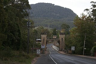
Kangaroo Valley is a river valley along the Kangaroo River in the Shoalhaven region of New South Wales, Australia, located west of the seaside in the City of Shoalhaven. It is also the name of the small suburb within it, formerly known as Osborne, with a population of 879 in the 2016 census. The township is accessed by the Moss Vale Road, which links Moss Vale to the Princes Highway at Bomaderry a little north of Nowra via the B73 route.
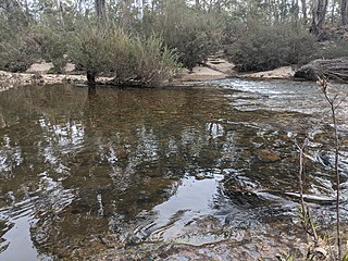
The Kangaroo River is a perennial river of the Shoalhaven catchment located in the Southern Highlands and Illawarra regions of New South Wales, Australia.

Boro is a rural locality of New South Wales, Australia in the Queanbeyan-Palerang Region, near the village of Tarago, about 50 km south of Goulburn. The name is a variation of the Aboriginal bora ring. At the 2021 census, it had a population of 97.
Barrengarry is a small village near the Southern Highlands of New South Wales, Australia, in City of Shoalhaven. It is situated north of Kangaroo Valley. At the 2016 census, it had a population of 200.
Yalwal is the site of a former gold mining town of the same name situated 29 km (18 mi) west of Nowra at the confluence of the Danjera and Yarramunmun Creeks which then forms Yalwal Creek which flows into the Shoalhaven River. It is now the site of a City of Shoalhaven managed picnic area and Danjera Dam. Yalwal is also the name of a modern locality, which includes the former mining town but extends over an extensive area of forests to its south, which largely forms parts of the Morton National Park. It is also the name of a parish, which lies to the north of the former mining town and generally north of the locality of Yalwal, generally in the area of the modern locality of Ettrema.

The Cordeaux River, a perennial river of the Hawkesbury-Nepean catchment, is located in the Southern Highlands and Macarthur regions of New South Wales, Australia.

Greenwell Point is a town in the Shoalhaven region of New South Wales, Australia. It is about 13 km east of Nowra on the South Coast. At the 2021 census, the town had a population of 1,245.

Wattamolla is a locality in the City of Shoalhaven in New South Wales, Australia. It lies in the valley of Brogers Creek about 16 km east of Kangaroo Valley. At the 2016 census, it had a population of 61.

Beaumont is a locality in the City of Shoalhaven in New South Wales, Australia. It lies on Cambewarra Range about 18 km north of Nowra on both sides of the Kangaroo Valley–Nowra road. It includes the Cambewarra Mountain lookout, which gives a good view of the lower Shoalhaven valley. At the 2016 census, it had a population of 125.

Cambewarra Village is a locality in the City of Shoalhaven in New South Wales, Australia. It lies on Main Road, which runs west from Cambewarra Road, which forms part of the Kangaroo Valley–Nowra road, about 9 km northwest of Nowra and south of Cambewarra Mountain. At the 2016 census, it had a population of 1,189. Cambewarra Village is largely surrounded by the locality of Cambewarra.

Ballalaba is a locality in the Queanbeyan–Palerang Regional Council, New South Wales, Australia. It is located about 30 km southwest of Braidwood on the road to Cooma and on the Shoalhaven River. At the 2021 census, it had a population of 29. It had a "half-time" school from 1867 to 1870; from 1879 to 1940, it operated either as a "provisional" or a "half-time" school".

Bendoura is a locality in the Queanbeyan–Palerang Regional Council, New South Wales, Australia. It is located about 20 km southwest of Braidwood on the road to Cooma and on the eastern bank of the Shoalhaven River. At the 2021 census, it had a population of 108.
Berlang is a locality in Queanbeyan-Palerang Regional Council, New South Wales, Australia. It was previously called Tallaganda. The town lies about 44 km south of Braidwood on the upper Shoalhaven River and the road to Cooma. At the 2021 census, it had a population of none. It includes part of the Deua National Park and the Berlang State Conservation Area. The Big Hole is a notable geological feature in the locality and the Deua National Park.
Krawarree is a rural locality in Queanbeyan–Palerang Regional Council.

Berry Mountain is a locality in the City of Shoalhaven in New South Wales, Australia. It lies west of the Princes Highway on the Kangaroo Valley Road between Berry and Kangaroo Valley. It lies about 23 kilometre north of Nowra and about 160 km south of Sydney. At the 2016 census, it had a population of 28. It lies on a ridge and is partly covered by temperate rain forest and partly by grasslands that were formerly used for dairying, but are now mainly used for rural residences.
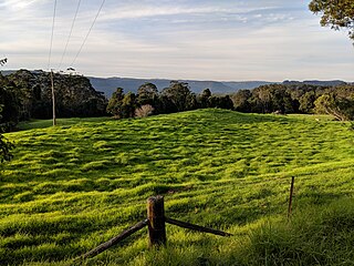
Bellawongarah is a locality in the City of Shoalhaven in New South Wales, Australia. It lies west of the Princes Highway on the Kangaroo Valley Road between Berry and Kangaroo Valley. It lies about 23 kilometre north of Nowra and about 160 km south of Sydney. At the 2016 census, it had a population of 127. It lies on a ridge and is partly covered by temperate rain forest and partly by grasslands that were formerly used for dairying, but are now mainly used for rural residences.

Bangalee is a suburb of Nowra in the City of Shoalhaven in New South Wales, Australia. It lies north of the Shoalhaven about 7 km to the northwest of Nowra. At the 2016 census, it had a population of 657.

Bundewallah is a locality in the City of Shoalhaven in New South Wales, Australia. It lies to the north of the Kangaroo Valley Road to the northwest of Berry. At the 2016 census, it had a population of 48.

Far Meadow is a locality in the City of Shoalhaven in New South Wales, Australia. It lies to the south of Coolangatta Road to the southeast of Berry. At the 2021 census, it had a population of 209.
Bolong is a locality in the City of Shoalhaven in New South Wales, Australia. It lies to the north of the Shoalhaven River and to the west of Broughton Creek. It is northeast of Nowra. At the 2016 census, it had a population of 104.
