
The Jervis Bay Territory is a territory of the Commonwealth of Australia. It was surrendered by the state of New South Wales to the Commonwealth Government in 1915 so that the Australian Capital Territory would have access to the sea.

The City of Shoalhaven is a local government area in the south-eastern coastal region of New South Wales, Australia. The area is approximately 200 kilometres (120 mi) south of Sydney. The area is located adjacent to the Tasman Sea. The Princes Highway passes through the area and the South Coast railway line traverses the northern section of the area and terminates at Bomaderry. At the 2016 census, the population of the City of Shoalhaven was 99,650.
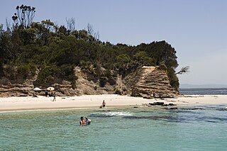
Jervis Bay is a 102-square-kilometre (39 sq mi) oceanic bay and village on the south coast of New South Wales, Australia, said to possess the whitest sand in the world. It is surrounded by Jervis Bay and Wreck Bay.

Nowra is a town in the South Coast region of New South Wales, Australia. It is located 160 kilometres (99 mi) south-southwest of the state capital of Sydney With its twin-town of Bomaderry, as at June 2018, Nowra had an estimated population of 37,420. It is also the seat and commercial centre of the City of Shoalhaven. Geologically, the city is situated in the southern reaches of the Sydney basin.

Palm Beach is a suburb in the Northern Beaches region of Sydney, in the state of New South Wales, Australia. Palm Beach is located 41 kilometres (25 mi) north of the Sydney central business district, in the local government area of Northern Beaches Council. Palm Beach sits on a peninsula at the end of Barrenjoey Road, between Pittwater and Broken Bay. The population of Palm Beach was 1,593 as at the 2016 census.

Brisbane Water is a wave-dominated barrier estuary located in the Central Coast region, north of Sydney, New South Wales, Australia. Brisbane Water has its origin at the confluence of the Narara and Coorumbine Creeks, to the south–east of Gosford and travels for approximately 18 kilometres (11 mi) in a southerly direction to its mouth at Broken Bay, about 7 kilometres (4.3 mi) from the Tasman Sea, at Barrenjoey Head. A number of towns and suburbs surround the shores of Brisbane Water, including Blackwall, Booker Bay, Davistown, Empire Bay, Erina, Ettalong Beach, Gosford, Green Point, Hardys Bay, Kilcare, Kincumber, Koolewong, Phegans Bay, Point Frederick, Point Clare, Saratoga, Tascott, Wagstaffe, and Woy Woy. Contained within Brisbane Water is St Huberts Island, Rileys Island, and Pelican Island; and adjoining the estuary is Brisbane Water National Park to the west and Bouddi National Park to the east. Forming part of the same tidal estuary system is a separate but connected basin, the Kincumber Broadwater, lying to the east of Davistown.

Huskisson is a town in New South Wales, Australia in the City of Shoalhaven, on the shores of Jervis Bay. It is 24 km south-east of Nowra.

Vincentia is a town in New South Wales, Australia in the City of Shoalhaven, on the shores of Jervis Bay. It is roughly 25 kilometres (16 mi) southeast of Nowra, and approximately 200 kilometres (120 mi) south of Sydney. At the 2016 census, the population of Vincentia was 3,290. It is also a tourist spot with a beach area featuring white sand and a number of motels.
Culburra Beach, commonly referred to as Culburra, is a town located in the South Coast region of New South Wales, Australia. Located within the Shoalhaven local government area, the town is 18 kilometres (11 mi) east-southeast of Nowra. At the 2016 census, the town had a population of 2,874 and is the regional centre for the coastal villages of Currarong, Callala Beach, Callala Bay and Orient Point.

Hyams Beach is a seaside village in the City of Shoalhaven, New South Wales, Australia, on the shores of Jervis Bay. At the 2016 census, it had a population of 112. The village, 180 km south of Sydney, is bordered by two beaches, Chinaman's Beach to the north and Seaman's Beach to the south, with Hyams Beach being in the centre. A seaside resort, its beach is known for having turquoise/aqua-coloured waters and fine, squeaky, brilliantly white sand that's composed of pure quartz. The village is a 3-hour drive from Sydney and can be accessed via Princes Motorway from the Sydney CBD or Hume Motorway from Greater Western Sydney.

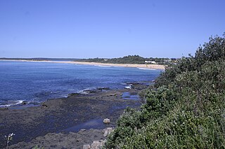
The South Coast refers to the narrow coastal belt from Shoalhaven district in the north to the border with Victoria in the south in the south-eastern part of the State of New South Wales, Australia. It is bordered to the west by the coastal escarpment of the Southern Tablelands, and is largely covered by a series of national parks, namely Jervis Bay National Park, Eurobodalla National Park, and Ben Boyd National Park. To the east is the coastline of the Pacific Ocean, which is characterised by rolling farmlands, small towns and villages along a rocky coastline, interspersed by numerous beaches and lakes.
Wrights Beach is a town in the City of Shoalhaven in New South Wales, Australia. It is on the shores of St Georges Basin, near the Jervis Bay Territory.

Callala Bay is a small town on the South Coast of New South Wales, Australia in the City of Shoalhaven.
Jerrinja is the name of an Aboriginal Australian people from the South Coast of New South Wales, Australia. Their traditional lands cover from Crooked River in the north to Clyde River in the south, from the coast in the east to the mountains in the west. It includes the areas of Shoalhaven which include Jervis Bay, Culburra Beach, Orient Point, Greenwell Point and Shoalhaven Heads.
Jones Beach, also known as Boyds Beach, is a beach on the south-eastern coast of Australia, facing the Tasman Sea. The beach is east of the settlement of Kiama Downs and about 2 kilometres (1.2 mi) south by east of the settlement of Minnamurra in the Illawarra and South Coast regions of New South Wales.
Stockton Beach is located north of the Hunter River in New South Wales, Australia. It is 32 km (20 mi) long and stretches from Stockton, to Anna Bay. Over many years Stockton Beach has been the site of numerous shipwrecks and aircraft crash sites. In World War II it was fortified against a possible attack by Imperial Japanese forces. During that time it served as a bombing and gunnery range as well as a dumping area for unused bombs by aircraft returning from training sorties. The length of the beach, its generally hard surface and numerous items of interest along the beach make it popular with four-wheel drive (4WD) enthusiasts. Four-wheel drive vehicles are permitted to drive on Stockton Beach provided the vehicles are in possession of valid permits. The beach is also popular with fishermen and several different varieties of fish may be caught.

Currarong is a small coastal fishing and tourist village in the Shoalhaven area of New South Wales, Australia. At the 2011 census, Currarong had a population of 452. The village is a haven for fishermen, with several underwater rises where fish are abundant. Currarong has a small general store, a newsagent and a cafe. As of early 2013 there is a fish cafe called Zac's Place, a general store, a licensed club, a caravan park, and several properties available for holiday rental.
St Georges Basin is an open intermediate estuary, or inland sea, located in the South Coast region of New South Wales, adjacent to the Jervis Bay Territory.

Moncrieff Bay is a bay in the Australian state of South Australia located at the east end of the Dudley Peninsula on Kangaroo Island in the gazetted locality of Willoughby overlooking Backstairs Passage about 106 kilometres (66 mi) south-west of the state capital of Adelaide and about 47 kilometres (29 mi) south-east of the municipal seat of Kingscote.

The Hive Shipwreck is a heritage-listed shipwreck site of the Hive, a former convict transportation ship located at Bherwerre Beach, Wreck Bay, off City of Shoalhaven on the South Coast of New South Wales, Australia. It was added to the New South Wales State Heritage Register on 1 April 2010.

