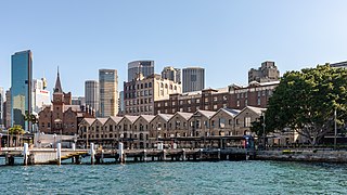
The Rocks is a suburb, tourist precinct and historic area of Sydney's city centre, in the state of New South Wales, Australia. It is located on the southern shore of Sydney Harbour, immediately north-west of the Sydney central business district.

Wahroonga is a suburb in the Upper North Shore of Sydney, in the state of New South Wales, Australia, 18 kilometres north-west of the Sydney central business district, in the local government areas of Ku-ring-gai Council and Hornsby Shire. North Wahroonga is an adjacent separate suburb of the same postcode.

Glebe is an inner-western suburb of Sydney in New South Wales. Glebe is located 3 kilometres (1.9 mi) southwest of the Sydney central business district in the Inner West region.

Potts Point is a small and densely populated suburb in inner-city Sydney, New South Wales, Australia. Potts Point is located 2 kilometres (1.2 mi) east of the Sydney central business district and is part of the local government area of the City of Sydney.
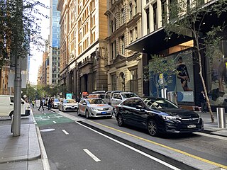
Pitt Street is a major street in the Sydney central business district in New South Wales, Australia. The street runs through the entire city centre from Circular Quay in the north to Waterloo, although today's street is in two disjointed sections after a substantial stretch of it was removed to make way for Sydney's Central railway station. Pitt Street is well known for the pedestrian only retail centre of Pitt Street Mall, a section of the street which runs from King Street to Market Street.
John Verge (1782–1861) was an English architect, builder, pioneer settler in the Colony of New South Wales, who migrated to Australia and pursued his career there. Verge was one of the earliest and the most important architect of the Greek Revival in Australia. He also brought more comprehensive range of Regency style than any contemporary architects. His design indicates the increasing of sophistication compared to previous architect's design.

Woollahra Municipal Council is a local government area in the eastern suburbs of Sydney, in the state of New South Wales, Australia. Woollahra is bounded by Sydney Harbour in the north, Waverley Council in the east, Randwick City in the south and the City of Sydney in the west.

Rushcutters Bay is a harbourside inner-east suburb of Sydney, in the state of New South Wales, Australia, 3 kilometres east of the Sydney central business district in the local government area of the City of Sydney.

Millers Point is an inner-city suburb of Sydney, in the state of New South Wales, Australia. It is on the north-western edge of the Sydney central business district, adjacent to The Rocks and is part of the local government area of the City of Sydney.

Darling Point is a harbourside eastern suburb of Sydney, Australia. It is 4 kilometres east of the Sydney central business district and is part of the local government area of Woollahra Council.

Wollondilly Shire is a periurban local government area, located on the south west fringe of the Greater Sydney area in New South Wales, Australia, parts of which fall into the Macarthur, Blue Mountains and Central Tablelands regions in the state of New South Wales, Australia. Wollondilly is seen as the transition between Regional NSW and the Greater Sydney Region, and is variously categorised as part of both. Wollondilly Shire was created by proclamation in the NSW Government Gazette on 7 March 1906, following the passing of the Local Government (Shires) Act 1905, and amalgamated with the Municipality of Picton on 1 May 1940.

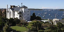
Elizabeth Bay House is a heritage-listed Colonial Regency style house and now a museum and grotto, located at 7 Onslow Avenue in the inner eastern Sydney suburb of Elizabeth Bay in the City of Sydney local government area of New South Wales, Australia. The design of the house is attributed to John Verge and John Bibb and was built from 1835 to 1839 by James Hume. The grotto and retaining walls were designed by Verge and the carriage drive on Onslow Avenue was designed by Edward Deas Thomson and built from 1832 to 1835 by convict and free artisans under the direction of Verge. The property is owned by Sydney Living Museums, an agency of the Government of New South Wales. Known as "the finest house in the colony", Elizabeth Bay House was originally surrounded by a 22-hectare (54-acre) garden, and is now situated within a densely populated inner city suburb.

Colonel Walter Liberty Vernon was an English architect who migrated to Australia and pursued his career as an architect in Sydney, New South Wales. In his role as the New South Wales Government Architect he is noted for designing multiple government buildings, many of which are extant with listings on national and state heritage registers.
Tresco is a heritage-listed residence located at 97 Elizabeth Bay Road, Elizabeth Bay, City of Sydney, New South Wales, Australia. It was designed by Thomas Rowe and built by Rowe from 1867 to 1883. The property is privately owned. It was added to the New South Wales State Heritage Register on 2 April 1999. The property has previously functioned as a private residence, navy housing, and homestead and was originally indigenous lands. Before 2004 it was owned by the Royal Australian Navy and served as an official residence for the senior naval officers in New South Wales.

Mosman is a suburb on the Lower North Shore region of Sydney, in the state of New South Wales, Australia. Mosman is located 8 kilometres north-east of the Sydney central business district and is the administrative centre for the local government area of the Municipality of Mosman.

Ashton is a heritage-listed mansion located at 102 Elizabeth Bay Road in the inner eastern Sydney suburb of Elizabeth Bay, New South Wales, Australia. It was designed by Thomas Rowe and built from 1874 to 1875. It is also known as Ashton and its grounds and Caprera (c.1875–c.1910); Brema or Braemar (c.1910–c.1920); The German Consulate.a The property is privately owned. It was added to the New South Wales State Heritage Register on 19 November 2003.

Edgerley is a heritage-listed residence located at 18–18a Billyard Avenue in the inner eastern Sydney suburb of Elizabeth Bay in the City of Sydney local government area of New South Wales, Australia. It is also known as Ramona; Haughly. The property is owned by interests associated with the Paspaley family. It was added to the New South Wales State Heritage Register on 2 April 1999.