Alexandria, New South Wales

Last updated

Alexandria
Sydney,  New South Wales
Alexandria Parkview Hotel.JPG
Parkview Hotel, Mitchell Road
Australia New South Wales location map blank.svg
Red pog.svg
Alexandria
Alexandria, New South Wales
Coordinates 33°54′06″S151°12′00″E / 33.90166°S 151.20007°E / -33.90166; 151.20007
Population9,649 (SAL 2021) [1]
 • Density1,540/km2 (4,000/sq mi)
Postcode(s) 2015
Elevation15 m (49 ft)
Area3.8 km2 (1.5 sq mi)
Location4 km (2 mi) south of Sydney CBD
LGA(s) City of Sydney
State electorate(s)
Federal division(s) Sydney
Suburbs around Alexandria:
Erskineville Eveleigh Redfern, Waterloo
Newtown Alexandria Zetland, Beaconsfield
St Peters Mascot Green Square, Rosebery

Alexandria is an inner southern suburb of Sydney, New South Wales, Australia. Alexandria is located 5 kilometres south of the Sydney central business district and is part of the local government area of the City of Sydney. The postcode is 2015. [2]

Contents

The rough boundaries of Alexandria are Botany Road to the east, Gardeners Road to the south, Mitchell Road and Sydney Park to the west, and Boundary Road to the north. It is approximately 3.5 km south of Central station.

History

The Parish of Alexandria was established in 1835. The naming of Alexandria and neighbouring Waterloo commemorates the famous British Empire military and naval victories over Napoleon – the Battles of Alexandria and Waterloo. The Iron Duke Hotel in Alexandria is itself named after the Duke of Wellington, as is Wellington Street in Waterloo. It was thought Alexandria may have been named after Princess Alexandra, Queen consort of King Edward VII, however, Alexandra was born on 1 December 1844 and the parish's naming predates the birth of Alexandra by six years.

In 1868, the Municipality of Alexandria was formed, after separating from Waterloo. The former Alexandria Town Hall is in Garden Street. [3] Land for the building was acquired in 1879; the building was designed by Ferdinand Reuss Snr and completed in 1881. Major alterations took place over the years, right up to 1928. The building is listed on the New South Wales State Heritage Register. [4]

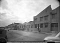
By 1943, Alexandria was the largest industrial district in Australia, and known as the "Birmingham of Australia", with everything from bricks to aeroplanes manufactured in 550 factories in just 1,000 acres (4.0 km2). [5] The municipality was abolished upon merger into the City of Sydney in 1949, along with Darlington, Erskineville, Newtown, Redfern, Waterloo, Paddington and The Glebe.

In 1968 the boundaries were changed again and Alexandria was part of a new municipality, South Sydney Council. South Sydney was brought back into the City of Sydney in 1982 and then became separate again under the City of Sydney Act of 1988. In 2004, Alexandria moved back into the City of Sydney, when the City of Sydney was merged with the City of South Sydney.

Trams

Tram lines, Mitchell Road, early 1950s Mitchel Rd. Alexandria 1950s.jpg
Tram lines, Mitchell Road, early 1950s
Tram from Mitchell Road in Henderson Road early 1900s Tram from Mitchell Rd. into Henderson Rd.Alexandria..jpg
Tram from Mitchell Road in Henderson Road early 1900s

The former Alexandria tram line opened in 1902 as a single-track electric line that was duplicated in 1910. The line branched off from the Botany line at the junction of Henderson and Botany Roads in Alexandria. The line proceeded down Henderson Road then swung left into Mitchell Road. A turn-back was provided at Ashmore Road (near Erskineville Oval) for short working. The line turned right into the present day Sydney Park Road (then known as an extension of Mitchell Road) before terminating at the junction with the Cook's River line at the Princes Highway near St Peters railway station. Services operated from Circular Quay in a route similar to the Botany line as far as the Henderson Road junction. The line was closed in 1959. Transit Systems route 308 generally follows the route as far as St Peters station.

Heritage listings

Alexandria has a number of heritage-listed sites, including:

Demographics

At the 2021 census, there were 9,649 people living in Alexandria. [9] At the 2016 census, Alexandria had a population of 8,262. [10]

Aboriginal and Torres Strait Islander people made up 1.8% of the population. The most common ancestries in Alexandria were Australian 31.6%, English 24.3%, Irish 13.6%, Chinese 10.1% and Scottish 9.9%. 59.9% of people were born in Australia. The most common other countries of birth were England 5.1%, New Zealand 3.3%, China (excludes SARs and Taiwan) 2.6%, the United States 1.4% and Indonesia 1.2%. 74.1% of people spoke only English at home. Other languages spoken at home included Mandarin 3.1%, Spanish 2.0%, Cantonese 1.9%, Portuguese 1.0% and Indonesian 1.0%. The most common responses for religion in Alexandria were No Religion 57.2%, Catholic 16.4%, Anglican 5.0% and Buddhism 3.0%. 65.2% of residences were flats and 29.0% were semi-detached, row or terrace house, townhouse etc. [9]

Commercial area

Alexandria is a largely industrial suburb with medium to high density residential areas. The suburb was once mostly terraced housing, that was demolished for light industrial use and warehousing which continues to this day. Pockets of quiet residential areas remain along the northern boundary of the suburb, adjoining Erskineville and Waterloo.

Virgin Atlantic has its Australia offices on Level 3 Eastside in the Sydney Corporate Park in Alexandria. [11]

One of the landing points of the trans-Pacific submarine telecommunications cable, the Southern Cross Cable, is located in the suburb. [12]

Green Square

Alexandria is part of the Green Square district, in the north east of the suburb, which is undergoing gentrification. This involves an urban renewal project that is constructing modern retail, business and medium-high density residential developments.

South Sydney markets

Established in September 2009, its main purpose was to meet the community demand for local markets, providing fine produce and a venue for local handmade crafts. The children's activities kept the little ones entertained with face painting and a kids zoo. It was open every Sunday 10am - 3pm at O'Riordan St Alexandria however, it has unfortunately been temporarily closed.

Transport

Alexandria is serviced by Transdev John Holland routes to the Sydney central business district. Alexandria is close to two railway lines on the Sydney Trains network. Green Square railway station, located on the north-eastern fringe, is on the Airport & South Line. Erskineville railway station and St Peters railway station are serviced by the Bankstown Line. Both are within easy walking distance, to the west of Alexandria.

Culture

Sport and recreation

Sydney Park is a large recreational area on the western border. Alexandria Park and McKell Playground are situated on Buckland Street. Tennis courts and a cricket oval are located here. Erskineville Oval is just over the western border. Erskineville Oval is the home ground of the Alexandria Rovers junior rugby league team. [15] The Alexandria Dukes Rugby Football Club play in the New South Wales Suburban Rugby Union competition and will again contest the Meldrum Cup in 2014. The club rooms for the Dukes are at the Iron Duke Hotel.

A number of popular pubs are located in the suburb including the Alexandria Hotel (reopened), Iron Duke Hotel, Buckland Hotel and the Parkview Hotel on Mitchell Road.

Related Research Articles

<span class="mw-page-title-main">Newtown, New South Wales</span> Suburb of Sydney, New South Wales, Australia

Newtown, a suburb of Sydney's inner west, is located approximately four kilometres south-west of the Sydney central business district, straddling the local government areas of the City of Sydney and Inner West Council in the state of New South Wales, Australia.

<span class="mw-page-title-main">Mascot, New South Wales</span> Suburb of Sydney, New South Wales, Australia

Mascot is a suburb in the Inner-South of Sydney, in the state of New South Wales, Australia. Mascot is located 7 kilometres south of the Sydney central business district and is one of the administrative centres of the Bayside Council. A small part of Mascot is located in the Inner West Council. Mascot is on the north-west side of Botany Bay and contains Sydney Airport.

<span class="mw-page-title-main">Redfern, New South Wales</span> Inner suburb of Sydney, Australia

Redfern is an inner southern suburb of Sydney located 3 kilometres (1.9 mi) south of the Sydney central business district and is part of the local government area of the City of Sydney. Strawberry Hills is a locality on the border with Surry Hills. The area experienced the process of gentrification and is subject to extensive redevelopment plans by the state government, to increase the population and reduce the concentration of poverty in the suburb and neighbouring Waterloo.

<span class="mw-page-title-main">Camperdown, New South Wales</span> Suburb of Sydney, New South Wales, Australia

Camperdown is an inner western suburb of Sydney, in the state of New South Wales, Australia. Camperdown is located 4 kilometres south-west of the Sydney central business district and is part of the Inner West region. Camperdown lies across the local government areas of the City of Sydney and Inner West Council.

<span class="mw-page-title-main">Botany, New South Wales</span> Suburb of Sydney, New South Wales, Australia

Botany is a suburb in the Eastern Suburbs of Sydney, in the state of New South Wales, Australia. Botany is located 11 kilometres south of the Sydney central business district and is part of the Bayside Council.

<span class="mw-page-title-main">Surry Hills, New South Wales</span> Suburb of Sydney, New South Wales, Australia

Surry Hills is an inner-east suburb of Sydney, in the state of New South Wales, Australia. Surry Hills is immediately south-east of the Sydney central business district in the local government area of the City of Sydney. Surry Hills is surrounded by the suburbs of Darlinghurst to the north, Chippendale and Haymarket to the west, Moore Park and Paddington to the east and Redfern to the south. It is often colloquially referred to as "Surry".

<span class="mw-page-title-main">Randwick, New South Wales</span> Suburb of Sydney, New South Wales, Australia

Randwick is a suburb in the Eastern Suburbs of Sydney, in the state of New South Wales, Australia. Randwick is located 6 kilometres south-east of the Sydney central business district and is the administrative centre for the local government area of the City of Randwick. The postcode is 2031.

<span class="mw-page-title-main">Glebe, New South Wales</span> Suburb of Sydney, New South Wales, Australia

Glebe is an inner-western suburb of Sydney in New South Wales. Glebe is located 3 kilometres (1.9 mi) southwest of the Sydney central business district and is part of the local government area of the City of Sydney, in the Inner West region.

<span class="mw-page-title-main">Potts Point</span> Suburb of Sydney, New South Wales, Australia

Potts Point is a small and densely populated suburb in inner-city Sydney, New South Wales, Australia. Potts Point is located 2 kilometres (1.2 mi) east of the Sydney central business district and is part of the local government area of the City of Sydney.

<span class="mw-page-title-main">Paddington, New South Wales</span> Suburb of Sydney, Australia

Paddington is an upscale Eastern Suburb of Sydney, in the state of New South Wales, Australia. Located 3 kilometres (1.9 mi) east of the Sydney central business district, Paddington lies across two local government areas. The portion south of Oxford Street lies within the City of Sydney, while the portion north of Oxford Street lies within the Municipality of Woollahra. It is often colloquially referred to as "Paddo".

<span class="mw-page-title-main">Erskineville</span> Suburb of Sydney, New South Wales, Australia

Erskineville is a suburb in the Inner West of Sydney, New South Wales, Australia. It is located 6 kilometres south west of the Sydney central business district and is part of the local government area of the City of Sydney. Erskineville is a diverse suburb homing to a wide variety of ethnicity from its varying Southeast Europe and Aboriginal community. Erskineville is colloquially known as Erko.

<span class="mw-page-title-main">St Peters, New South Wales</span> Suburb of Sydney, New South Wales, Australia

St Peters is a suburb in the Inner West of Sydney, in the state of New South Wales, Australia. It is 7 kilometres south of the Sydney central business district, in the local government area of Inner West Council, with a small section in the southeast in the City of Sydney.

<span class="mw-page-title-main">Millers Point, New South Wales</span> Suburb of Sydney, New South Wales

Millers Point is an inner-city suburb of Sydney, in the state of New South Wales, Australia. It is on the north-western edge of the Sydney central business district, adjacent to The Rocks and is part of the local government area of the City of Sydney.

<span class="mw-page-title-main">Dawes Point, New South Wales</span> Suburb of Sydney, Australia

Dawes Point is a suburb of the City of Sydney, in the state of New South Wales, Australia. Dawes Point is located on the north-western edge of the Sydney central business district, at the southern end of Sydney Harbour Bridge, adjacent to The Rocks. At times Dawes Point has been considered to be part of The Rocks, or known as West Rocks, part of Millers Point, or part of it known as Walsh Bay.

<span class="mw-page-title-main">Sydney Park</span>

Sydney Park is a 41.6-hectare (103-acre) recreational area in the inner-city area of Sydney, New South Wales, Australia. The parkland is located in the suburb of Alexandria, sitting along the borders with Newtown and Erskineville.

<span class="mw-page-title-main">Erskineville Oval</span>

Erskineville Oval is a sporting venue in Erskineville, Sydney, New South Wales, Australia. Originally developed and opened in 1885 as Macdonaldtown Park, it was later renamed in 1892 to its current form with the municipality name change of the local government body. At approximately a capacity of 5000 spectators, previously 2000 Erskineville Oval was formerly an AFL venue as of 1903 when the NSW Australian Football League was founded. From 1913, the ground become a rugby venue as well, in which it has since hosted professional teams such as Newtown and the South Sydney Rabbitohs.

<span class="mw-page-title-main">Alexandra Canal (New South Wales)</span> River in New South Wales, Australia

The Alexandra Canal, a tributary of the Cooks River, is a heritage-listed artificial waterway in southern Sydney, New South Wales, Australia. Alexandra Canal was named after Princess Alexandra, who married Edward, Prince of Wales in 1863.

<span class="mw-page-title-main">Waterloo Town Hall, Sydney</span> Government town hall in New South Wales, Australia

The Waterloo Town Hall is a heritage-listed town hall located in Waterloo, a suburb of Sydney, New South Wales, Australia. Located at 770 Elizabeth Street, it was built in 1880–82 in the Victorian Italianate architectural style with Second Empire elements by John Smedley, Edward Hughes and Ambrose Thornley. The town hall was the seat of Waterloo Municipal Council from 1882 to 1948 and since 1972 has been the Waterloo Library, a branch of the City of Sydney Library servicing Waterloo and Alexandria.

<span class="mw-page-title-main">Yiu Ming Temple</span> Chinese temple in City of Sydney, New South Wales, Australia

Yiu Ming Temple is a heritage-listed Chinese temple at 16–22 Retreat Street, Alexandria, City of Sydney, New South Wales, Australia. Built in 1908–1909, Yiu Ming Temple is one of the oldest surviving Chinese temples in Australia and a globally rare intact example of the traditional Chinese village temple form. While commonly known as the "Yiu Ming Temple", its formal name is Hong Sheng Gong or Hung Sheng Gong, which indicates that it is a Hung Shing Temple. It is also sometimes known as Yiu Ming Hung Fook Tong Temple(Chinese: 要明洪福堂), which is strictly the name of the previous temple used by the same community. It was added to the New South Wales State Heritage Register on 24 September 1999.

References

  1. Australian Bureau of Statistics (28 June 2022). "Alexandria (suburb and locality)". Australian Census 2021 QuickStats. Retrieved 28 June 2022.  OOjs UI icon edit-ltr-progressive.svg
  2. Gregory's Sydney Street Directory, Gregory's Publishing Company, 2007
  3. Book of Sydney Suburbs, Frances Pollon (Angus and Robertson) 1990, p. 2
  4. "Alexandria Town Hall including interior". www.environment.nsw.gov.au. NSW Environment & Heritage.
  5. Residents Guide 2007. City of Sydney.
  6. "Alexandra Canal". New South Wales State Heritage Register . Department of Planning & Environment. H01621. Retrieved 18 May 2018. CC BY icon.svg Text is licensed by State of New South Wales (Department of Planning and Environment) under CC-BY 4.0 licence .
  7. "Enginemans Resthouse". New South Wales State Heritage Register . Department of Planning & Environment. H00723. Retrieved 18 May 2018. CC BY icon.svg Text is licensed by State of New South Wales (Department of Planning and Environment) under CC-BY 4.0 licence .
  8. "Yiu Ming Temple". New South Wales State Heritage Register . Department of Planning & Environment. H01297. Retrieved 18 May 2018. CC BY icon.svg Text is licensed by State of New South Wales (Department of Planning and Environment) under CC-BY 4.0 licence .
  9. 1 2 Australian Bureau of Statistics (28 June 2022). "Alexandria". 2021 Census QuickStats. Retrieved 3 December 2022. OOjs UI icon edit-ltr-progressive.svg
  10. Australian Bureau of Statistics (27 June 2017). "Alexandria (State Suburb)". 2016 Census QuickStats. Retrieved 2 July 2017. OOjs UI icon edit-ltr-progressive.svg
  11. "Australia Office." Virgin Atlantic. Retrieved 14 December 2009.
  12. Access Points Southern Cross Cables
  13. "Diocese Archived 6 July 2011 at the Wayback Machine ." Diocese of Australia and New Zealand. Retrieved 27 February 2011. "EPISCOPAL HEADQUARTERS 14 Renwick St, Alexandria NSW 2015"
  14. "Yiu Ming Temple". www.environment.nsw.gov.au. NSW Environment & Heritage.
  15. "Alexandria Rovers Rugby League Football Club". www.alexandriarovers.com.au.