The first land grants in the area were made in 1835, with market gardening being the main land use. Subdivision followed the construction of Botany Road in 1875 and a municipality known as North Botany was formed in 1888. A racecourse operated in this area in 1904 on land that was formerly owned by the Australian Golf Club. The race course was known as Ascot, named after its famous counterpart in England. Residents wanted the area to have an individual identity and a referendum was held in 1911 to choose between Ascot, and Booralee.[2] An objection from the postal authorities to the use of 'Ascot' led the council to alter the name to Mascot.[3]
In 1920, Mascot was chosen as the site of a public airfield. Nigel Love was leasing 200 acres (81ha; 0.81km2) from the Kensington Race club and in 1921 the Commonwealth Government purchased 161 acres (65ha; 0.65km2) for this purpose. The first regular flights began in 1924. The suburb became the headquarters of Qantas as its hub in 1935. The Cooks River was diverted away from the area between 1947 and 1953 to provide more land for the airport.[4][5]
In the early 1970s a large meeting of residents successfully requested that the NSW Builders Labourers Federation place a ban on the construction of town-house type dwellings if there was not sufficient green area retained around them.[6]
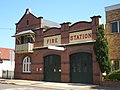
Mascot has a mixture of residential, commercial and industrial areas. The main shopping centre is located on Botany Road. The area around Mascot railway station is being redeveloped to contain high-density commercial and residential developments. The Police Headquarters for the local Botany Bay Area Command is on Botany Road and Mascot Ambulance Station is situated directly opposite. Mascot Fire Station is located in Coward Street, beside the City of Botany Bay Council Chambers.
Sydney Airport, Australia's principal airport, is an influential presence and key employer. The head office of Qantas is the Qantas Centre at 203 Coward Street in Mascot.[9] There are also a number of airport hotels in the suburb.
Transport
Mascot is serviced by a number of bus routes, which are operated by Transdev John Holland and Transit Systems. Routes 303, 306, 309, 310 and 350, routes travel down Botany Road. Routes 343 and 356 services travel down Gardeners Road and route 305 departs from the Qantas Centre.
At the 2021 census, the population of Mascot was 21,591, of which 35.1% were born in Australia. The most common foreign countries of birth were China 11.4%, Indonesia 9.8%, Mongolia 2.6%, India 2.6% and Ireland 2.2%. Some 37.9% of people only spoke English at home. Other languages spoken at home included Mandarin 12.5%, Indonesian 8.3%, Cantonese 4.2%, Spanish 3.8% and Greek 2.7%. The most common responses for religion were No Religion 34.7% and Catholic 23.5%. Of occupied private dwellings in Mascot, 74.3% were flats or apartments; 21.0% were separate houses; and 3.9% were semi-detached, row- or terrace houses, townhouses etc.[1]
Mascot is in the safe Labor state electorate of Heffron, which has been held by Ron Hoenig since 2012.[12]
Schools
Mascot Public School is a primary school in King Street[13] and J. J. Cahill Memorial High School is located in Sutherland Street.[14]
St Therese School Mascot is located in Sutherland Street.[15]
Gardeners Road Primary school is on the Rosebery side of Gardeners Road, but attracts a number of students from Mascot.[16]
Places of worship
Knox Presbyterian Church built in 1911
Self-Realization Fellowship Sydney Centre
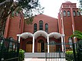
St Catherine's Greek Orthodox Church
Parks and recreation
L'Estrange Park is home to both the Mascot Kings (soccer) and the Mascot Juniorsrugby league teams. Mascot Oval is the venue for the Mascot Juniors' home games. The Lakes Golf Club has hosted many international golf tournaments.
Gallery
St Catherine's Greek Orthodox Church, Coward Street
This page is based on this Wikipedia article Text is available under the CC BY-SA 4.0 license; additional terms may apply. Images, videos and audio are available under their respective licenses.