Related Research Articles
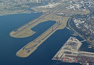
Sydney Kingsford Smith Airport — colloquially Mascot Airport, Kingsford Smith Airport, or Sydney Airport — is an international airport serving Sydney, New South Wales, Australia, 8 km (5.0 mi) south of the Sydney central business district, in the suburb of Mascot. Sydney Airport is the busiest airport in Oceania. It is the primary airport serving Sydney and is a primary hub for Qantas, as well as a secondary hub for Virgin Australia and Jetstar, and a focus city for Rex Airlines.

Mascot is an inner south and west suburb of Sydney, in the state of New South Wales, Australia. Mascot is located 7 kilometres south of the Sydney central business district and is one of the administrative centres of the Bayside Council. A small part of Mascot is located in the Inner West Council. Mascot is on the north-west side of Botany Bay and contains Sydney Airport.

Botany is a suburb in the Inner Southern Suburbs of Sydney, in the state of New South Wales, Australia. Botany is located 11 kilometres south of the Sydney central business district and is part of the Bayside Council.

The Airport & South Line is a suburban commuter rail line in Sydney, Australia. It connects the Sydney central business district with the southwestern suburbs via Sydney Airport. The line is part of the Sydney Trains network. The line began operating on 26 November 2017, when the T2 Airport, Inner West & South Line was split in two. Sydney Trains' predecessor CityRail operated the Airport & East Hills Line over an identical route between 2000 and 2013.

Kensington is a suburb in the eastern suburbs of Sydney, New South Wales, Australia. It is located four kilometres south-east of the Sydney central business district, in the local government area (LGA) of the City of Randwick.

Ascot is a north-east suburb in the City of Brisbane, Queensland, Australia. In the 2021 census, Ascot had a population of 6,531 people.
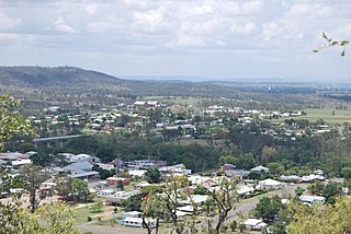
Gayndah is a town and locality in the North Burnett Region, Queensland, Australia. It is the administrative centre for the North Burnett Region. In the 2021 census, the locality of Gayndah had a population of 1,949 people.

Zetland is an inner southern suburb of Sydney, New South Wales, Australia 4 kilometres south of the Sydney central business district, in the local government area of the City of Sydney. The postcode is 2017.

The Division of Kingsford Smith is an Australian electoral division in the state of New South Wales. It is located south and south-east of Sydney CBD, comprising mostly City of Randwick and the suburbs of Bayside Council that were governed by the former City of Botany Bay.

Croydon Park is a suburb in the Inner West of Sydney, in the state of New South Wales, Australia. Croydon Park is 10 kilometres south-west of the Sydney central business district and is divided between the local government areas of the City of Canterbury-Bankstown, Municipality of Burwood and Inner West Council. Croydon is a separate suburb, to the north.
Eastlakes is an inner southern and eastern suburb of Sydney, in the state of New South Wales, Australia. Eastlakes is located 8 kilometres south of the Sydney central business district, in the local government area of the Bayside Council, Eastlakes is mostly residential with a shopping centre located at Evans Avenue. The residential portion of the suburb falls in the inner south being west of the Eastern Distributor while the non-residential side of the suburb consisting of The Lakes Golf Course and Botany Dams is east of the Eastern Distributor falling within the Eastern Suburbs, south-east of the CBD.

Enfield is a suburb in the Inner West of Sydney, in the state of New South Wales, Australia. It is 11 kilometres south-west of the Sydney central business district in the local government area of Municipality of Burwood.

Ermington is a suburb of Sydney, New South Wales, Australia. Ermington is located 19 kilometres West of the Sydney central business district, in the local government area of the City of Parramatta. Ermington lies on the northern bank of the Parramatta River.

Eagle Farm is an eastern industrial suburb of the City of Brisbane, Queensland, Australia. In the 2021 census, Eagle Farm had a population of 11 people.

Mascot railway station is located on the Airport line, serving the Sydney suburb of Mascot. It is served by Sydney Trains' T8 Airport & South Line services.

Sydney, the largest city in Australia, has an extensive network of passenger and goods railways. The passenger system includes an extensive suburban railway network, operated by Sydney Trains, a metro system and a light rail network. A dedicated goods network also exists.

Cockle Bay is a small bay in inner-city Sydney, New South Wales, Australia. It is located on the western edge of the Sydney central business district.
Mudgee Airport is a regional airport located 3 nautical miles north northeast of Mudgee, New South Wales, Australia. The airport is frequently used for technical training. FlyPelican operates a flight to Sydney, making it the only commercial airline serving Mudgee.

General Holmes Drive is a 5-kilometre (3.1 mi) major divided road located in Sydney, New South Wales, Australia. The road forms part of the M1, the A1, the Sydney Orbital Network, and the Australian Highway 1 network. Initially built in 1919 as a two-lane road and duplicated in 1951, the road partially circumnavigates Sydney Airport with its north-eastern terminus in Mascot, heading west and then south and then south-west, with its south-western terminus with The Grand Parade in Brighton-Le-Sands.
Victoria Park Racecourse was a racecourse in Zetland, an inner-city suburb, south of Sydney, New South Wales, Australia. It was bordered by O’Dea Avenue, South Dowling Street, Epsom Road and Joynton Avenue.
References
- ↑ "Harold Park Heritage Report - Section 4" (PDF). Ascot Racecourse. Archived from the original (PDF) on 2 April 2012. Retrieved 28 December 2010.
- ↑ Peake, W. Unregistered Proprietary Horseracing in Sydney, 1888-1942 Archived 2007-09-05 at the Wayback Machine University of Western Sydney, December 2004.
- ↑ Timmony, PJ.Handling Heavy Traffic on Special Occasions. 6 February 1934, from Action For Public Transport.
- 1 2 Sydney Airport Environment 2006-2010 Archived August 31, 2007, at the Wayback Machine
33°56.3′S151°11.4′E / 33.9383°S 151.1900°E
| | This article about a horse racing venue is a stub. You can help Wikipedia by expanding it. |