
Granville is a suburb in Western Sydney, in the state of New South Wales, Australia. Granville is located 18 kilometres (11 mi) west of the Sydney central business district, split between the local government areas of Cumberland City Council and the City of Parramatta.

Redfern is an inner southern suburb of Sydney located 3 kilometres (1.9 mi) south of the Sydney central business district and is part of the local government area of the City of Sydney. Strawberry Hills is a locality on the border with Surry Hills. The area experienced the process of gentrification and is subject to extensive redevelopment plans by the state government, to increase the population and reduce the concentration of poverty in the suburb and neighbouring Waterloo.

Rhodes is an Inner West suburb of Sydney, in the state of New South Wales, Australia. Rhodes is located 12 kilometres west of the Sydney central business district, in the local government area of the City of Canada Bay. It was formerly part of Concord Municipality until a merger with Drummoyne Council to form Canada Bay in December 2000.

Homebush is a suburb in the Inner West of Sydney in the state of New South Wales, Australia. It is located 12 kilometres west of the Sydney central business district, in the local government area of the Municipality of Strathfield.

Arncliffe is a suburb in southern Sydney, in the state of New South Wales, Australia. Arncliffe is located 11 kilometres south of the Sydney central business district, in the local government area of the Bayside Council.

Surry Hills is an inner-east suburb of Sydney, in the state of New South Wales, Australia. Surry Hills is immediately south-east of the Sydney central business district in the local government area of the City of Sydney. Surry Hills is surrounded by the suburbs of Darlinghurst to the north, Chippendale and Haymarket to the west, Moore Park and Paddington to the east and Redfern to the south. It is often colloquially referred to as "Surry".

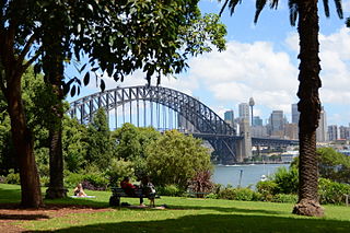
Kirribilli is a suburb of Sydney, New South Wales, Australia. One of the city's most established and affluent neighbourhoods, it is located three kilometres north of the Sydney central business district, in the local government area administered by North Sydney Council. Kirribilli is a harbourside suburb, sitting on the Lower North Shore of Sydney Harbour. Kirribilli House is one of the two official residences of the Prime Minister of Australia.

Summer Hill is a suburb of Sydney, in the state of New South Wales, Australia. Summer Hill is located 7 kilometres west of the Sydney central business district, in the local government area of the Inner West Council.
Lavender Bay is a harbourside suburb on the lower North Shore of Sydney, New South Wales, Australia. Lavender Bay is located 3 kilometres north of the Sydney central business district, in the local government area of North Sydney Council.

Kensington is a suburb in the eastern suburbs of Sydney, New South Wales, Australia. It is located four kilometres south-east of the Sydney central business district, in the local government area (LGA) of the City of Randwick.

Woollahra is a suburb in the Eastern Suburbs of Sydney, in the state of New South Wales, Australia. Woollahra is located 5 kilometres east of the Sydney central business district, in the local government area of the Municipality of Woollahra. Woollahra is located on the traditional land of the Birrabirragal and Gadigal people of the Eora Nation. The Municipality of Woollahra takes its name from the suburb but its administrative centre is located in Double Bay. Woollahra is famous for its quiet, tree-lined residential streets and village-style shopping centre.

Zetland is an inner southern suburb of Sydney, New South Wales, Australia 4 kilometres south of the Sydney central business district, in the local government area of the City of Sydney.

Gladesville is a suburb in the Lower North Shore of Sydney, in the state of New South Wales, Australia. Gladesville is located 10 kilometres north-west of the Sydney central business district, in the local government area of the City of Ryde and the Municipality of Hunter's Hill. Gladesville is part of the federal electorates of North Sydney and Bennelong.

Rosebery is an inner southern suburb of Sydney, in the state of New South Wales, Australia. It is 6 kilometres south of the Sydney central business district and is part of the local government areas of the City of Sydney and the Bayside Council.

Bardwell Park is a suburb in southern Sydney, in the state of New South Wales, Australia. The suburb is located 12 kilometres south-west of the Sydney central business district and is part of the St George area. Bardwell Park is in the local government area of the Bayside Council. Bardwell Valley is a separate suburb, to the east.
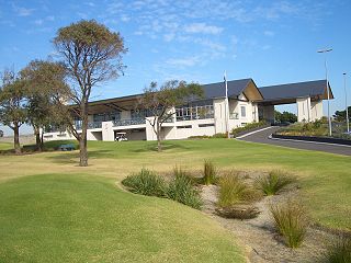
Eastlakes is an inner southern and eastern suburb of Sydney, in the state of New South Wales, Australia. Eastlakes is located 8 kilometres south of the Sydney central business district, in the local government area of the Bayside Council, Eastlakes is mostly residential with a shopping centre located at Evans Avenue. The residential portion of the suburb falls in the inner south being west of the Eastern Distributor while the non-residential side of the suburb consisting of The Lakes Golf Course and Botany Dams is east of the Eastern Distributor falling within the Eastern Suburbs, south-east of the CBD.

The Gaelic Theatre is a split level multi purpose venue in Surry Hills, New South Wales, Australia. The theatre is located on the ground floor of INA House, close to Central railway station and was voted “Best Live Music Venue - NSW” at the 2007 Jack Awards.

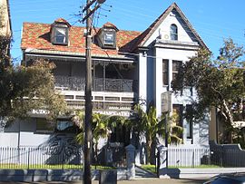
The Cleveland House is a heritage-listed former residence, hospital, convent and aged care facility and now vacant building located at 146–164 Chalmers Street, Surry Hills, City of Sydney, New South Wales, Australia. The building is located at the rear of the block and is best viewed from Bedford Street. Its design was attributed to Francis Greenway and built from 1823. It is also known as Cleaveland. The property is privately owned. It was added to the New South Wales State Heritage Register on 2 April 1999.

The Crown Street Public School is a heritage-listed public primary school located at Crown Street, Surry Hills, City of Sydney, New South Wales, Australia. It was designed by George Allen Mansfield and built from in 1869 by A. Scott, Mackay and Son. It was added to the New South Wales State Heritage Register on 2 April 1999.

Golden Grove is an urban place in Sydney, in the state of New South Wales, Australia. It is 4 kilometres south-west of the Sydney central business district, adjacent to the suburbs of Newtown, Darlington and Eveleigh. Golden Grove is part of the local government area of the City of Sydney. The locality is around Golden Grove Street, surrounding Forbes Street, Wilson Street, Abercrombie Street, along with the Golden Grove Housing Estate, Forbes Street Reserve, Golden Grove Ministry Centre. The former suburb of the postcode 2006 was named after the First Fleet store ship that left Portsmouth on 13 May 1787, and arrived at Port Jackson, Sydney Australia, on 26 January 1788.
 Australia Post NSW headquarters
 Cleveland Street High School
