Erskineville is bordered by the suburbs of Newtown to the west, Redfern to the north, St Peters to the south, and Alexandria to the east. The locality of Macdonaldtown sits over the north-west border.
Erskineville is a residential suburb. Erskineville Oval is located on the eastern border of the suburb.
The suburb was originally called Macdonaldtown after an earlier subdivision in 1846 in the south of Erskineville owned by Stephen Macdonald.
The area of Macdonaldtown/Erskineville was established as a residential and farming area in the early 19th century.[2]Nicholas Devine, the first principal superintendent of convicts called his land Burren Farm, after a region of County Clare in his native Ireland. Burren Farm would later become parts of Newtown and Macdonaldtown (now Erskineville).[3] Devine Street is named after Nicholas Devine and Burren street is named after his farm.
The streets around the early Macdonaldtown subdivision are named after relations of the Macdonald family - Amy, Flora, Eve, Coulson and Rochford. Knight Street is named for Henry Knight, one of the earliest brickmakers in the district and the first mayor of Macdonaldtown.
Macdonaldtown Map 1886 -1889 (City of Sydney Archives)
Erskineville is named after Erskine Villa, the home of Wesleyan minister, Reverend George Erskine, built in 1830. After changing owners a few times, the property was eventually left to the Church of England and became the rectory for the Holy Trinity Church at Macdonaldtown (it was demolished in 1961 after serving as the rectory for eighty years).[4]
The area was first incorporated on 23 May 1872, with the name of the "Municipal District of Macdonald Town" (but was variously known as the "Borough of Macdonald Town" or the "Municipality of Macdonaldtown").[5] On 19 July 1872, the first council, consisting of six aldermen in one electorate, was elected (Charles Brandling Henderson, Henry Knight, James Bryan, Alexander Swanson, William Irwin and James Heighington), with Henry Knight elected as the first mayor at the first meeting on 23 July 1872.[6][7]
In 1893 Macdonaldtown was renamed as Erskineville, when the Parliament of New South Wales passed the "Borough of Erskineville Naming Act, 1893", effecting the municipal name change.[8][9] In the late nineteenth century, the inhabitants were originally market gardeners, though brick making and tanning also became dominant industries. The Victorian cottages and small rows of Victorian terraces that dominate the built form of the suburb were the homes of the workers in these industries, which explains their smallness: a four-metre wide terrace is large by Erskineville standards.
In the early twentieth century, manufacturing in the area diversified, and Erskineville became a resolutely working class inner city suburb. In 1938 the Erskineville Public Housing Scheme was inaugurated on the western end of Erskineville Park, as an early response by the NSW Government to the Housing Improvement Act 1937 towards the problem of slum clearance in the inner city.[10][11][12] From the 1970s, Erskineville underwent gentrification with new residents attracted to the village atmosphere, public transport links and the proximity to the CBD.
Sydney Park Road
From the 19th century until the second half of the 20th century, the south-eastern section of Erskineville was taken up by large industrial uses. Bakewell Brothers brick and pottery works operated until 1956, and Metters Limited had a large factory that made items such as the "Kooka" stove operating from 1907 to 1974. Steelworks like McPherson’s and Hadfields Steel Works also operated until the 1970s.[13] The site of these industrial works were identified since 1998 as a site for urban renewal, with the land east of the rail line, south of Ashmore Street and north of Coulson Street known as the "Ashmore Estate". The Ashmore Estate is currently identified for major residential redevelopment as part of the urban renewal process.[13][14]
In 1971, two people were killed by cars on Union Street, and residents began petitioning their council for street closures. A number of Erskineville streets were closed on a trial basis from mid-1984. On Christmas Eve 1985, road barriers in 11 streets in Erskineville, Alexandria, Newtown and Redfern were ordered to be removed by the Minister for Local Government, Kevin Stewart, leading to a period of local unrest.[15] On December 31st 1985, practically all the road closures were reinstated.[16]
The Erskineville line opened as an electric double track tramway in 1909. It branched from tracks at Regent Street in Chippendale, and passed west along Meagher Street, then south into Abercrombie Street. It followed Abercrombie Street south across the junction with Cleveland Street through Golden Grove, before swinging south into Golden Grove Street then right into Wilson Street. The line then passed under the railway lines at Burren Street, adjacent to the entrance to Macdonaldtown railway station. The line then became a single track loop passing up Burren Street to Erskineville Road, then west along Erskineville Road to Septimus Street, then Albert Street before rejoining the tracks at Burren Street. Services operated from Circular Quay using the Pitt and Castlereagh Street lines. The line south of Cleveland Street closed in 1940, with the northern section used by other services until its closure in 1958.
The Henderson Road line was a short line that branched from the Alexandria line tracks at the corner of Henderson and Mitchell Roads in Alexandria and passed along Henderson Road to Park Street in Erskineville, and later to Bridge Street adjacent to Erskineville railway station. Services operated from Circular Quay with the line opening to Park Street in 1906 and to Bridge Street in 1909. The line was an electrified single track throughout. The line was an early closure in 1933 and was replaced by a private bus service that no longer operates.
A poster traced back to the Cicada 3301 online puzzle was in this suburb.
Population
Historical population
Year
Pop.
±%
2001
4,818
—
2006
6,558
+36.1%
2011
6,848
+4.4%
2016
8,014
+17.0%
2021
9,657
+20.5%
At the 2021 census the population of Erskineville had risen to 9,657, from 8,014 residents in 2016.[18] The most common reported ancestries were English 34.8%, Australian 24.4%, Irish 14.6%, Scottish 10.2% and Chinese 9.6%. 59.2% of people were born in Australia. The next most common countries of birth were England 7.7%, China 3.5% and New Zealand 3.2%. 76.6% of people spoke only English at home. Other languages spoken at home included Mandarin 3.7%, Spanish 1.7% and Cantonese 1.7%. The most common responses for religious affiliation were No Religion 65.8% and Catholic 12.5%. On the day of the Census, 6.2% of employed people used public transport as at least one of their methods of travel to work and 13.9% used car (either as driver or as passenger). The main housing types were flats or units 61.7%, semi-detached or townhouses 34.5% and separate houses 3.2%. Just over half of residents (53.3%) were renting, compared with the national average of 30.6%.[19]
The house in Burren Street, Macdonaldtown (now Erskineville), where John and Sarah Makin resided (from the Illustrated Sydney News, 12 November 1892)
John and Sarah Makin also known as the Hatpin Murderers were 'baby farmers' who were convicted for murder in 1892 after bodies were found buried in their yard.[20]
Erskineville is covered by HCAs in approximately 75% of its area. These include:
Burren Estate Heritage Conservation Area, covering the northern triangle of the suburb bounded with Newtown, including the Town Hall.[24]
Toogood and White's Estate Heritage Conservation Area, located south of Erskineville Road to Victoria Street.[25]
Former Macdonaldtown Heritage Conservation Area, covers the suburb from Munni Street south the Bray Street west of the rail line.[26]
Pleasant Avenue Heritage Conservation Area, located south of the Former Macdonaldtown HCA between Rochford Street and Smiths Lane down to Macdonald Street.[27]
King Street Heritage Conservation Area (part), shared with Newtown, is located in Erskineville south of Union Street and ends at Concord Street.[28]
Erskineville Estate Heritage Conservation Area, covers the 1885 Macdonaldtown Parkand and the inter-war Erskineville Housing Scheme.[29]
Malcolm Estate Heritage Conservation Area, covers the suburb east of the Station including the Public School, west of Binning Street and along Ashmore Street.[30]
Kingsclear Road Heritage Conservation Area (part), shared with Alexandria, covers the suburb south of Railway Parade, west of Park Street and east of Sydney Street.[31]
Items listed on the Sydney Local Environmental Plan
former Cosmopolitan Hotel (1880–1910), on 11 Charles Street, is a former hotel in the late Victorian style with a second floor added in the Federation Free Classical style c. 1910 designed by Lindsay Thompson.[32]
former Bakewell Brothers south-east warehouse (now Brightwell Transport site; 1914–1919), on 7-19 Coulson Street, is a former warehouse of the Bakewell brick and pottery works listed in 2016 as a result of the 2014 City of Sydney Industrial and Warehouse Buildings heritage study.[33]
Imperial Hotel (c. 1940), on 35-37 Erskineville Road, is an Inter War Functionalist style pub designed by Virgil Dante Cizzio.[34]
Holy Trinity Anglican Church Group (1885–1961), on 55 Erskineville Road, includes the 1885 church designed by the Blacket brothers, sons of Edmund Blacket.[4]
Erskineville Hotel (1940), on 102 Erskineville Road, is an Art Deco pub designed by Copeman, Lemont & Keesing.[35]
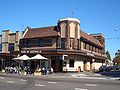
Erskineville Town Hall (1938), on 104 Erskineville Road, was designed in the Inter-War Mediterranean style by Lindsay Scott and served as the seat of the Municipality of Erskineville until 1948 and the City of South Sydney until 2003.[36]
The facade of the former St Peter's Theatre (1927), on 672 King Street, is the Federation Romanesque style facade remaining of the picture theatre designed by Emil Sodersten.[37]
Former factory chimney stack (1916), on 127 Railway Parade, is a remnant chimney stack "significant for its connection to Australian manufacturing of hosiery and underwear during the 1920s and 1940s, gramophones and records in the 1920s and 1930s and textiles between the 1940s and 1980s." Listed in 2016 as a result of the 2014 City of Sydney Industrial and Warehouse Buildings heritage study[38]
former Macdonaldtown Post Office (c. 1873), on the corner of Rochford and Knight Streets, was built by Henry Knight, a mayor of Macdonaldtown.[39]
Rose of Australia Hotel (1934), on the corner of Swanson Street and George Street, is an Inter War Free Classical style pub designed by Prevost and Ruwald.[41]
St Mary's Catholic Church Group (1912), on 21-23 Swanson Street, was built in the Federation Arts & Crafts style as a memorial to Rev. Father Reginald Bridge, designed by J.McCarthy.[42]
former Cleveland Shoe Company factory (1923), on 18-20 Victoria Street, is a former factory designed in the inter-war Chicagoesque style listed in 2016 as a result of the 2014 City of Sydney Industrial and Warehouse Buildings heritage study.[43]
Electricity Substation No. 101 (1919), on 1A Ashmore Street, is listed under the Ausgrid Heritage Register and is also listed under the Sydney LEP.[46][47]
↑"MUNICIPAL DISTRICT OF MACDONALD TOWN". Government Gazette of the State of New South Wales. No.203. New South Wales, Australia. 23 July 1872. p.1865. Retrieved 24 September 2016– via National Library of Australia.
↑"Advertising". Sydney Morning Herald. Vol.LXVI, no.10, 663. New South Wales, Australia. 22 July 1872. p.1. Retrieved 24 September 2016– via National Library of Australia.
↑"THE ERSKINEVILLE SCHEME". Construction. Vol.LI, no.1609. New South Wales, Australia. 1 February 1939. p.8. Retrieved 27 July 2018– via National Library of Australia.
↑"ERSKINEVILLE HOUSING SCHEME". The Sydney Morning Herald. No.31, 249. New South Wales, Australia. 26 February 1938. p.8. Retrieved 27 July 2018– via National Library of Australia.
This page is based on this Wikipedia article Text is available under the CC BY-SA 4.0 license; additional terms may apply. Images, videos and audio are available under their respective licenses.