Forest Lodge, New South Wales

Last updated

Forest Lodge
Sydney,  New South Wales
Forest Lodge 2.JPG
Pyrmont Bridge Road
Population4,965 (SAL 2021) [1]
Postcode(s) 2037
Area0.3 km2 (0.1 sq mi)
LGA(s) City of Sydney
State electorate(s) Balmain
Federal division(s) Sydney
Suburbs around Forest Lodge:
Glebe
Annandale Forest Lodge Glebe
Camperdown

Forest Lodge is a small, inner-city suburb of Sydney, in the state of New South Wales, Australia. Forest Lodge is located 4 kilometres south-west of the Sydney central business district and is part of the local government area of the City of Sydney.

Contents

Location

Ross Street and the intersecting St Johns Road, form the centre of the neighbourhood, with a small collection of bars, cafes and antique stores. The area is popular with students from the nearby University of Sydney and UTS. It is considered to be a quieter alternative to neighbouring Glebe, which shares many of its features. The housing stock is predominantly Victorian, a sizeable proportion of which has been converted into apartment houses in varying states of restoration.

Schools

Forest Lodge Public School is on the corner of Pyrmont Bridge Road and Ross Street. The University of Sydney Centre for Peace and Conflict Studies is located here, as is the Medical Foundation.

Landmarks

Historic points of interest include the Forest Lodge Public School and the Chapman Steps. The former Alexandra Hospital is past the southern boundary in Camperdown and the Glebe Town Hall is just over the eastern boundary of the suburb at Mount Vernon Street, Glebe.
At the intersection of Wigram Road and Minogue Crescent can be found the Lew Hoad Reserve, a small park named in honour of Lew Hoad. Hoad was born in 1934 and grew up at 43 Wigram Road. He learned to play tennis in the area and from the age of nine was a daily visitor to the Police Boy's Club next to the reserve where he participated in boxing, wrestling, gymnastics, athletics, cricket and rugby league. Hoad went on to be a member of Australia's four Davis Cup winning squads in 1952 to 1956, won Wimbledon twice and was the world's number one tennis player in 1956 before turning professional. The reserve was named after him in 1965. [2]

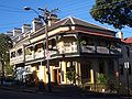
The Forest Lodge Hotel (commonly referred to as 'The Flodge') is popular with students and families, and won the TimeOut Pub Awards in 2015, 2016, and was nominated in 2017.

History

Forest Lodge was named after a house built in the area in 1836 by Ambrose Foss. The house stood on the present site of 208-210 Bridge Road until it was demolished in 1912. [3]

Population

At the 2021 census, the population of Forest Lodge had increased to 4,965. [4]

In the 2016 census, there were 4,583 people in Forest Lodge. 37.7% of people were attending an educational institution and of these, 55.7% were in a tertiary or technical institution. In Forest Lodge, 49.6% of people were born in Australia. The next most common countries of birth were China 11.4%, England 5.0% and New Zealand 2.6%. 62.4% of people spoke only English at home. Other languages spoken at home included Mandarin at 11.4%. The most common responses for religion were No Religion 51.8% and Catholic 14.5%. Of the employed people in Forest Lodge 6.8% worked in Higher Education. Other major industries of employment included Computer System Design and Related Services 4.0% and Hospitals (except Psychiatric Hospitals) 4.0%. The rate of car use was lower than average, with 32.9% of people travelling to work by car, compared with the national average of 64.6%. Of occupied private dwellings in Forest Lodge, 41.6% were semi-detached and 55.9% were flats or apartments. [5]

Related Research Articles

<span class="mw-page-title-main">Camperdown, New South Wales</span> Suburb of Sydney, New South Wales, Australia

Camperdown is an inner western suburb of Sydney, in the state of New South Wales, Australia. Camperdown is located 4 kilometres south-west of the Sydney central business district and is part of the Inner West region. Camperdown lies across the local government areas of the City of Sydney and Inner West Council.

<span class="mw-page-title-main">Bangor, New South Wales</span> Suburb of Sydney, New South Wales, Australia

Bangor is a suburb in southern Sydney, in the state of New South Wales, Australia. Bangor is located 28 kilometres south of the Sydney central business district, in the local government area of the Sutherland Shire in the area commonly called Menai. Bangor sits south of the Georges River and to the west of the Woronora River.

<span class="mw-page-title-main">Leichhardt, New South Wales</span> Suburb of Sydney, New South Wales, Australia

Leichhardt is a suburb in the Inner West of Sydney, in the state of New South Wales, Australia. Leichhardt is located 5 kilometres west of the Sydney central business district (CBD) and is the administrative centre for the local government area (LGA) of the Inner West Council. The suburb is bordered by Haberfield to the west, Annandale to the east, Lilyfield to the north and Petersham, Lewisham and Stanmore to the south.

<span class="mw-page-title-main">Glebe, New South Wales</span> Suburb of Sydney, New South Wales, Australia

Glebe is an inner-western suburb of Sydney in New South Wales. Glebe is located 3 kilometres (1.9 mi) southwest of the Sydney central business district and is part of the local government area of the City of Sydney, in the Inner West region.

<span class="mw-page-title-main">Chippendale, New South Wales</span> Suburb of Sydney, New South Wales, Australia

Chippendale is a small inner-city suburb of Sydney, New South Wales, Australia on the southern edge of the Sydney central business district, in the local government area of the City of Sydney. Chippendale is located between Broadway to the north and Cleveland Street to the south, Central railway station to the east and the University of Sydney to the west.

<span class="mw-page-title-main">Lilyfield, New South Wales</span> Suburb of Sydney, New South Wales, Australia

Lilyfield is a suburb in the Inner West of Sydney, in the state of New South Wales, Australia. Lilyfield is located 6 kilometres west of the Sydney central business district, in the local government area of the Inner West Council.

<span class="mw-page-title-main">Centennial Park, New South Wales</span> Suburb of Sydney, New South Wales, Australia

Centennial Park is a suburb split between the local government area of the City of Sydney and the City of Randwick, located 4 kilometres (2.5 mi) from the Sydney central business district, in the eastern suburbs of Sydney in the state of New South Wales, Australia.

<span class="mw-page-title-main">Pyrmont, New South Wales</span> Suburb of Sydney, New South Wales, Australia

Pyrmont is an inner-city suburb of Sydney, in the state of New South Wales, Australia 2 kilometres south-west of the Sydney central business district in the local government area of the City of Sydney. It is also part of the Darling Harbour region. As of 2011, it is Australia's most densely populated suburb.

<span class="mw-page-title-main">Ultimo, New South Wales</span> Suburb of Sydney, New South Wales, Australia

Ultimo is an inner-city suburb of Sydney, New South Wales, Australia. It is adjacent to the Sydney central business district in the local government area of the City of Sydney west of the Darling Harbour area, and is bordered by Pyrmont to the north, the Sydney CBD and Chinatown/Haymarket to the east, Broadway and Chippendale to the south, and Glebe and Wentworth Park to the west.

<span class="mw-page-title-main">Rozelle</span> Suburb of Sydney, New South Wales, Australia

Rozelle is a suburb in the inner west of Sydney, in the state of New South Wales, Australia. It is located 4 kilometres west of the Sydney central business district, in the local government area of the Inner West Council.

<span class="mw-page-title-main">Woollahra</span> Suburb of Sydney, New South Wales, Australia

Woollahra is a suburb in the Eastern Suburbs of Sydney, in the state of New South Wales, Australia. Woollahra is located 5 kilometres east of the Sydney central business district, in the local government area of the Municipality of Woollahra. Woollahra is located on the traditional land of the Birrabirragal and Gadigal people of the Eora Nation. The Municipality of Woollahra takes its name from the suburb but its administrative centre is located in Double Bay. Woollahra is famous for its quiet, tree-lined residential streets and village-style shopping centre.

<span class="mw-page-title-main">Alfords Point</span> Suburb of Sydney, New South Wales, Australia

Alfords Point is a suburb in southern Sydney, in the state of New South Wales, Australia. Alfords Point is 28 kilometres south of the Sydney central business district, within the local government area of the Sutherland Shire. Alfords Point shares the postcode of 2234 with neighbouring suburbs of Menai, Bangor and Illawong.

<span class="mw-page-title-main">Macquarie Park, New South Wales</span> Suburb of Sydney, New South Wales, Australia

Macquarie Park is a suburb in the Northern Sydney region of Sydney, New South Wales, Australia. Macquarie Park is located 13 kilometres north-west of the Sydney central business district in the local government area of the City of Ryde.

<span class="mw-page-title-main">Municipality of Leichhardt</span> Former local government area in New South Wales, Australia

The Municipality of Leichhardt was a local government area in the inner-west region of Sydney, New South Wales, Australia. It is about 10 kilometres (6.2 mi) west of the Sydney central business district. On 12 May 2016, Leichhardt merged with Marrickville Council and the Municipality of Ashfield to form the Inner West Council.

<span class="mw-page-title-main">Rosebery, New South Wales</span> Suburb of Sydney, New South Wales, Australia

Rosebery is an inner southern suburb of Sydney, in the state of New South Wales, Australia. It is 6 kilometres south of the Sydney central business district and is part of the local government areas of the City of Sydney and the Bayside Council.

<span class="mw-page-title-main">Point Piper</span> Suburb of Sydney, New South Wales, Australia

Point Piper is a small, harbourside eastern suburb of Sydney, in the state of New South Wales, Australia, 6 kilometres (4 mi) east of the Sydney CBD, in the local government area known as the Municipality of Woollahra.

<span class="mw-page-title-main">Kyeemagh</span> Suburb of Sydney, New South Wales, Australia

Kyeemagh is a suburb in southern Sydney, in the state of New South Wales, Australia. It is 12 kilometres south of the Sydney central business district, on the western shore of Botany Bay. Kyeemagh is in the local government area of the Bayside Council and is part of the St George area.

<span class="mw-page-title-main">Campsie, New South Wales</span> Suburb of Sydney, New South Wales, Australia

Campsie is a suburb in the state of New South Wales, Australia. Campsie is 11 kilometres south west of the Sydney central business district, on the southern bank of the Cooks River. Campsie is one of the administrative centres of the City of Canterbury-Bankstown.

<span class="mw-page-title-main">Balmain East</span> Suburb of Sydney, New South Wales, Australia

Balmain East is a suburb in the Inner West of Sydney, in the state of New South Wales, Australia. Balmain East is located three kilometres west of the Sydney central business district, in the local government area of the Inner West Council.

<span class="mw-page-title-main">Chatswood West, New South Wales</span> Suburb of Sydney, New South Wales, Australia

Chatswood West is a suburb on the Lower North Shore of Sydney, in the state of New South Wales, Australia. Chatswood West is located 11 kilometres north-west of the Sydney central business district, in the local government areas of the City of Willoughby and City of Ryde. Chatswood is a separate suburb to the east. The locality of Chatswood located west of the Pacific Highway is informally known as West Chatswood, and should not be confused with the separate suburb of Chatswood West, nor should it be confused with the West Chatswood Post Office on Railway Street in the suburb of Chatswood. Chatswood West shares the same postcode as Chatswood which is 2067.

References

  1. Australian Bureau of Statistics (28 June 2022). "Forest Lodge (suburb and locality)". Australian Census 2021 QuickStats. Retrieved 28 June 2022.  OOjs UI icon edit-ltr-progressive.svg
  2. "Lewis Hoad Reserve - City of Sydney". www.cityofsydney.nsw.gov.au. Archived from the original on 11 November 2013.
  3. The Book of Sydney Suburbs, Compiled by Frances Pollen, Angus & Robertson Publishers, 1990, Published in Australia ISBN   0-207-14495-8, page 105
  4. "2021 Forest Lodge, Census All persons QuickStats". Australian Bureau of Statistics. Retrieved 19 August 2022.
  5. Australian Bureau of Statistics (27 June 2017). "Forest Lodge (State Suburb)". 2016 Census QuickStats. Retrieved 14 March 2018. OOjs UI icon edit-ltr-progressive.svg

33°53′02″S151°10′53″E / 33.88396°S 151.18150°E / -33.88396; 151.18150