Pitt Street, Sydney | |
|---|---|
 | |
| Pitt Street, looking north | |
 | |
 Northern end Southern end | |
| Coordinates |
|
| General information | |
| Type | Street |
| Length | 2.5 km (1.6 mi) |
| Major junctions | |
| Northern end | Alfred Street Sydney CBD |
| Southern end | George Street Haymarket, Sydney |
| Location(s) | |
| LGA(s) | City of Sydney |
| Major suburbs | Sydney CBD, Haymarket |
Pitt Street is a major street in the Sydney central business district in New South Wales, Australia. The street runs through the entire city centre from Circular Quay in the north to Waterloo, although today's street is in two disjointed sections after a substantial stretch of it was removed to make way for Sydney's Central railway station. Pitt Street is well known for the pedestrian only retail centre of Pitt Street Mall, a section of the street which runs from King Street to Market Street.
Contents
- History
- Tram line
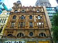
- Heritage-listed properties and notable buildings
- Pitt Street Cycleway
- Gallery
- References
- External links
Pitt Street is a one way (southbound only) from Circular Quay to Pitt Street Mall and (northbound only) from Pitt Street Mall to Goulburn Street, while Pitt Street Mall is for pedestrians only. It is dominated by retail and commercial office space.