
The Sydney Harbour Bridge is a steel through arch bridge in Sydney, New South Wales, Australia, spanning Sydney Harbour from the central business district (CBD) to the North Shore. The view of the bridge, the Harbour, and the nearby Sydney Opera House is widely regarded as an iconic image of Sydney, and of Australia itself. Nicknamed "the Coathanger" because of its arch-based design, the bridge carries rail, vehicular, bicycle and pedestrian traffic.
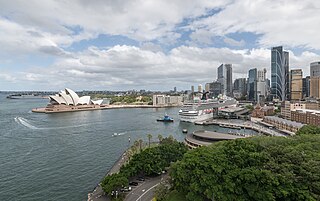
Circular Quay is a harbour, former working port and now international passenger shipping terminal, public piazza and tourism precinct, heritage area, and transport node located in Sydney, New South Wales, Australia, on the northern edge of the Sydney central business district on Sydney Cove, between Bennelong Point and The Rocks. It is part of the local government area of the City of Sydney.
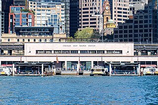
Circular Quay railway station is a heritage-listed elevated railway station that is located on the City Circle line, serving the Circular Quay precinct of the Sydney central business district in New South Wales, Australia. It is served by Sydney Trains' T2 Leppington & Inner West Line, T3 Liverpool & Inner West Line and T8 Airport & South Line services.

The North Shore is a region within Northern Sydney, in New South Wales, Australia, generally referring to suburbs located on the northern side of Sydney Harbour up to Berowra, and suburbs between Middle Harbour and the Lane Cove River. The term "North Shore", used to describe this region of Sydney is customary, not legal or administrative, and is often subjective.

Pacific Highway is a 790-kilometre-long (491 mi) national highway and major transport route along the central east coast of Australia, with the majority of the highway being part of Australia's Highway 1. The highway and its adjoining Pacific Motorway between Brisbane and Brunswick Heads and Pacific Motorway between Sydney and Newcastle links the state capitals of Sydney in New South Wales with Brisbane in Queensland. It approximately parallels the Tasman Sea and the Coral Sea of the South Pacific Ocean coast. Additionally, between Brunswick Heads and Port Macquarie, the road is also signed as Pacific Motorway, but has not been legally gazetted as such.

The Lane Cove River, a northern tributary of the Parramatta River, is a tide-dominated, drowned valley estuary west of Sydney Harbour, located in Sydney, New South Wales, Australia. The river winds through a bushland valley and joins Parramatta River at Greenwich and Woolwich, where together they form an arm of Sydney Harbour, and serves as a border along with Middle Harbour separating Sydney's North Shore.

Lane Cove is a suburb on the Lower North Shore of Sydney, New South Wales, Australia. Lane Cove is nine kilometres north-west of the Sydney central business district and is the administrative centre for the local government area of the Lane Cove Council. Lane Cove West and Lane Cove North are separate suburbs.

Wynyard railway station is a heritage-listed underground commuter rail station located in the north-west precinct of the Sydney central business district, in New South Wales, Australia. The station opened on 28 February 1932 to coincide with the opening of the Sydney Harbour Bridge.

North Sydney is a suburb and major commercial district on the Lower North Shore of Sydney, New South Wales, Australia. It is located three kilometres north of the Sydney central business district and is the administrative centre for the local government area of North Sydney Council.

John Job Crew Bradfield was an Australian engineer best known as the chief proponent of the Sydney Harbour Bridge, of which he oversaw both the design and construction. He worked for the New South Wales Department of Public Works from 1891 to 1933. He was the first recipient of an engineering doctorate from the University of Sydney, in 1924. Other notable projects with which he was associated include the Cataract Dam, the Burrinjuck Dam, and Brisbane's Story Bridge. The Harbour Bridge formed only one component of the City Circle, Bradfield's grand scheme for the railways of central Sydney, a modified version of which was completed after his death. He was also the designer of an unbuilt irrigation project known as the Bradfield Scheme, which proposed that remote areas of western Queensland and north-eastern South Australia could be made fertile by the diversion of rivers from North Queensland.

Milsons Point railway station is a heritage-listed suburban railway station located on the North Shore line, serving the Sydney suburb of Milsons Point. It is served by Sydney Trains T1 North Shore line services. The station is elevated and is accessible via both stairs and a lift. It was designed and built by the Sydney Harbour Bridge Branch of the NSW Department of Public Works. The property was added to the New South Wales State Heritage Register on 2 April 1999.

George Street is a street in the central business district of Sydney.

The Tank Stream is a heritage-listed former fresh water tributary of Sydney Cove and now tunnel and watercourse located in the Sydney central business district, in the City of Sydney local government area of New South Wales, Australia. The Tank Stream was the fresh water supply for the fledgling colony of New South Wales in the late 18th century. Today it is little more than a storm water drain. It originated from a swamp to the west of present-day Hyde Park and at high tide entered Sydney Cove at what is now the intersection of Bridge and Pitt Streets in the Sydney central business district. The catchment was 65 hectares, corresponding roughly the size of the Sydney central business district. It was added to the New South Wales State Heritage Register on 2 April 1999.

The Sydney tramway network served the inner suburbs of Sydney, Australia, from 1879 until 1961. In its heyday, it was the largest in Australia, the second largest in the Commonwealth of Nations, and one of the largest in the world. The network was heavily worked, with about 1,600 cars in service at any one time at its peak during the 1930s . Patronage peaked in 1945 at 405 million passenger journeys. Its maximum street trackage totalled 291 km in 1923.

Bradfield Highway is a 2.1-kilometre (1.3 mi) highway that crosses the Sydney Harbour Bridge in Sydney, New South Wales and is one of the shortest highways in Australia. It opened along with the bridge itself on 19 March 1932 and was named in honour of John Bradfield, the engineer who designed and helped construct it.

Warringah Freeway is a 3.5-kilometre (2.2 mi) divided freeway in Sydney, New South Wales, Australia that is part of the Sydney Orbital Network. The primary function of the freeway is to provide an alternative high-grade route from the Sydney Harbour Tunnel and Bradfield Highway at Milsons Point to the A8 and Gore Hill Freeway. The freeway reduces traffic demands on Pacific Highway throughout Sydney's Lower North Shore, bypassing North Sydney and Crows Nest, and provides a vital link to access most of the suburbs in Sydney and is also a major route to the north, south, east and west of the central business district.

Western Distributor is a 4.3-kilometre-long (2.7 mi) grade-separated motorway that is primarily elevated for the majority of its route on the western fringe of the Sydney central business district. It links the southern end of Bradfield Highway at the Sydney Harbour Bridge to Victoria Road in Rozelle, at its western terminus near White Bay. It is a constituent part of the A4 route.

Bathurst Street is a street in the Sydney central business district in New South Wales, Australia. Bathurst Street runs for 650 metres (2,130 ft) in a west–east direction with traffic flowing in this direction only. It is situated in the southern portion of the central business district. The western terminus of Bathurst Street is at Harbour Street, Darling Harbour, with the eastern terminus at Elizabeth Street, adjacent to Hyde Park.

Northern Sydney is a large metropolitan area in Greater Sydney, New South Wales, Australia on the north shore of Sydney Harbour and Parramatta River. The region embraces suburbs in Sydney's north-east, north and inner north west. Northern Sydney is divided into distinctive regions such as the North Shore, Northern Beaches and Forest District.
York Street is a street in the Sydney central business district in New South Wales, Australia. York Street runs 1.050 kilometres (0.652 mi) in a north to south direction only.
