
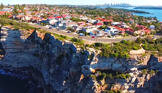
Wolseley Road is a road in the Sydney suburb of Point Piper. It is one kilometre long. It starts at New South Head Road and curves around the west side of Point Piper, terminating in a dead end above Lady Martins Beach.
Wolseley Road is a road in the Sydney suburb of Point Piper. It is one kilometre long. It starts at New South Head Road and curves around the west side of Point Piper, terminating in a dead end above Lady Martins Beach.
As at 2002, Wolseley Road was the most expensive residential road/street in Australia with 16 of the top 100 most expensive houses in Sydney being located on it. [1] Property writer Cindy Martin calculated in 2002 that the total value of the properties on the one-kilometre waterfront section of Wolseley Road was worth, in total, $720 million. [2]
In 2007, the Andrew Banks property on Wolseley Road was made an offer of $50 million, which was declined. [3] In 2022, 20 Wolseley Road sold for $45 million. [4]
In 2015, it was named the sixth most expensive street in the world. Notable residents included Frank Lowy and Malcolm Turnbull. [5]
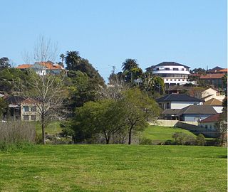
Houses in the area are designed according to the limited availability and price of land, as well as the physical nature of the location. There is considerable variety because every house is unique; in contrast to many Sydney suburbs, there has been no mass development with identical houses. The range of styles goes from Federation Arts and Crafts cottages to multi-storey mansions and some towers of home units.

The following items are Heritage Listed by Woollahra Council:

Hornsby is a suburb on the Upper North Shore of Sydney in the state of New South Wales, Australia, approximately 23 kilometres (14 mi) north-west of the Sydney central business district. It is the administrative centre of the local government area of Hornsby Shire.

Rose Bay is a harbourside, eastern suburb of Sydney, in the state of New South Wales, Australia. Rose Bay is located seven kilometres east of the Sydney central business district, in the local government areas of Waverley Council and Municipality of Woollahra.

Bondi Junction is an eastern suburb of Sydney, in the state of New South Wales, Australia. It is 6 kilometres east of the Sydney central business district and is part of the local government area of Waverley.
Randwick is a suburb in the Eastern Suburbs of Sydney, in the state of New South Wales, Australia. Randwick is located 6 kilometres south-east of the Sydney central business district and is the administrative centre for the local government area of the City of Randwick. The postcode is 2031.

Centennial Park is a suburb split between the local government area of the City of Sydney and the City of Randwick, located 4 kilometres (2.5 mi) from the Sydney central business district, in the eastern suburbs of Sydney in the state of New South Wales, Australia.

Double Bay is a harbourside eastern suburb of Sydney, in the state of New South Wales, Australia 4 kilometres east of the Sydney central business district. It is the administrative centre of the local government area of the Municipality of Woollahra.

Burwood is a suburb in the Inner West of Sydney, in the state of New South Wales, Australia. It is 10 kilometres (6.2 mi) west of the Sydney central business district and is the administrative centre for the local government area of Municipality of Burwood. People from Burwood are colloquially known as Burwoodiens or Burwooders.

Cremorne is a suburb on the Lower North Shore of Sydney, New South Wales, Australia, located 6 kilometres north-east of the Sydney central business district, in the local government area of North Sydney Council.

Woollahra is a suburb in the Eastern Suburbs of Sydney, in the state of New South Wales, Australia. Woollahra is located 5 kilometres east of the Sydney central business district, in the local government area of the Municipality of Woollahra. Woollahra is located on the traditional land of the Birrabirragal and Gadigal people of the Eora Nation. The Municipality of Woollahra takes its name from the suburb but its administrative centre is located in Double Bay. Woollahra is famous for its quiet, tree-lined residential streets and village-style shopping centre.

Bellevue Hill is a harbourside suburb in the eastern suburbs of Sydney, in the state of New South Wales, Australia, located five kilometres east of the Sydney central business district, in the Municipality of Woollahra.

Watsons Bay is a harbourside, eastern suburb of Sydney, in the state of New South Wales, Australia. Watsons Bay is located 11 km north-east of the Sydney central business district, in the local government area of the Municipality of Woollahra.
Vaucluse is an eastern suburb of Sydney, in the state of New South Wales, Australia. It is located 8 kilometres (5 mi) east of the Sydney central business district, in the local government areas of Waverley Council and the Municipality of Woollahra.
Undercliffe is an eastern section of the suburb of Earlwood located in South Western Sydney, New South Wales, Australia. Undercliffe is situated 10 kilometres south-west of the Sydney central business district within the local government area of the City of Canterbury-Bankstown.

Point Piper is a small, harbourside eastern suburb of Sydney, in the state of New South Wales, Australia, 6 kilometres (4 mi) east of the Sydney CBD, in the local government area known as the Municipality of Woollahra.

Darling Point is a harbourside eastern suburb of Sydney, Australia. It is 4 kilometres east of the Sydney central business district and is part of the local government area of Woollahra Council.
Bondi is a suburb of eastern Sydney, in the state of New South Wales, Australia, seven kilometres east of the Sydney central business district, in the local government area of Waverley Council.

Clareville is a suburb in northern Sydney, in the state of New South Wales, Australia. Clareville is 36 kilometres north-east of the Sydney central business district, in the local government area of Northern Beaches Council. Clareville is part of the Northern Beaches region.

Currawong Beach is a suburb in northern Sydney, in the state of New South Wales, Australia. Currawong Beach is 42 kilometres (26 mi) north of the Sydney central business district, in the local government area of Northern Beaches Council.

Mosman is a suburb on the Lower North Shore region of Sydney, in the state of New South Wales, Australia. Mosman is located 8 kilometres north-east of the Sydney central business district and is the administrative centre for the local government area of the Municipality of Mosman.

Fairwater is a heritage-listed residence and homestead at 560 New South Head Road, Double Bay, Sydney, Australia. It was designed by John Horbury Hunt (1882) and J. W. Manson and built from 1882 to 1970. Acquired by members of the Fairfax family in late 1900, following the 2017 death of Lady Mary Fairfax, the house is managed by the executors of her estate. It was added to the New South Wales State Heritage Register on 27 March 2000.
![]() Media related to Point Piper, New South Wales at Wikimedia Commons
Media related to Point Piper, New South Wales at Wikimedia Commons