
Eddy Avenue is a street in the Sydney central business district of New South Wales, Australia. It runs west from Elizabeth Street to Pitt Street outside Central station.
Eddy Avenue is a street in the Sydney central business district of New South Wales, Australia. It runs west from Elizabeth Street to Pitt Street outside Central station.
Eddy Avenue runs in a north-westerly direction for 200 metres from Elizabeth Street to Pitt Street. To the north Belmore Park runs along its full length, while to the south is Central station.
Three lanes of road traffic run in each direction. On its northern side it has a row of bus stops that are served by State Transit services to the Eastern Suburbs. On the southern side, two bus stands were served by Sydney Buses services to Railway Square and Greyhound Australia interstate services. In April 2017, the coach bays relocated to the western forecourt of Central station. [1] Since the introduction of the light rail services, the Big Bus Sydney sightseeing services stop in Pitt Street just south of Eddy Avenue.
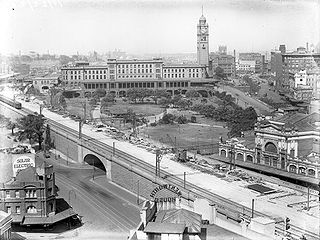
Until the early 1960s, Eddy Avenue had tram lines running down its central reservation. The CBD and South East Light Rail commenced operation along Eddy Avenue in December 2019 after construction commended in May 2017. [2] In July 1990, the 1910 built tram waiting shed was demolished as part of the construction of the coach terminal. [3]

Circular Quay is a harbour, former working port and now international passenger shipping port, public piazza and tourism precinct, heritage area, and transport node located in Sydney, New South Wales, Australia on the northern edge of the Sydney central business district on Sydney Cove, between Bennelong Point and The Rocks. It is part of the local government area of the City of Sydney.

Central is a heritage-listed railway station located in the centre of Sydney, New South Wales, Australia. The station is the largest and busiest railway station in Australia and serves as a major transport interchange for NSW TrainLink inter-city rail services, Sydney Trains commuter rail services, Sydney light rail services, State Transit and private bus services, and private coach transport services. The station is also known as Sydney Terminal. The property was added to the New South Wales State Heritage Register on 2 April 1999. It recorded 85.4 million passenger movements in 2018.

The Sydney light rail network is a light rail system serving the city of Sydney, New South Wales, Australia. The network currently consists of three passenger routes, the L1 Dulwich Hill, L2 Randwick and L3 Kingsford lines. The network comprises 42 stations and a system length of 24.7 km (15.3 mi), making it the second largest light rail network in Australia behind the Yarra Trams network in Melbourne, Victoria.

Pitt Street is a major street in the Sydney central business district in New South Wales, Australia. The street runs through the entire city centre from Circular Quay in the north to Waterloo, although today's street is in two disjointed sections after a substantial stretch of it was removed to make way for Sydney's Central railway station. Pitt Street is well known for the pedestrian only retail centre of Pitt Street Mall, a section of the street which runs from King Street to Market Street.

George Street is a street in the central business district of Sydney.
Lilyfield is a suburb in the Inner West of Sydney, in the state of New South Wales, Australia. Lilyfield is located 6 kilometres west of the Sydney central business district, in the local government area of the Inner West Council.
A one-way pair, one-way couple, or couplet refers to that portion of a bi-directional traffic facility – such as a road, bus, streetcar, or light rail line – where its opposing flows exist as two independent and roughly parallel facilities.

The Sydney tramway network served the inner suburbs of Sydney, Australia from 1879 until 1961. In its heyday, it was the largest in Australia, the second largest in the Commonwealth of Nations, and one of the largest in the world. The network was heavily worked, with about 1,600 cars in service at any one time at its peak during the 1930s . Patronage peaked in 1945 at 405 million passenger journeys. Its maximum street trackage totalled 291 km in 1923.

Elizabeth Street is a major street in the central business district of Sydney in New South Wales, Australia. The street continues south of the central business district (CBD), through the inner city suburbs of Surry Hills, Redfern and Waterloo, before terminating in Zetland. Elizabeth Street lies within the City of Sydney local government area.

Castlereagh Street is a 1.6-kilometre-long (0.99 mi) major street located in the Sydney central business district in New South Wales, Australia. The street runs in a north-to-south, in a one way direction only.

Transport in Sydney is provided by an extensive network of public transport operating modes including suburban rail, light rail, buses, metro and ferries, as well as an expansive network of roadways, cycleways and airports. According to the 2006 census, in terms of travel to work or study Sydney has the highest rate of public transport usage among the Australian capital cities of 26.3% with more than 80% of weekday trips to/from Central Sydney being made by public transport. According to the New South Wales State Plan, the state has Australia's largest public transport system. The public transport network is regulated by Transport for NSW.

Sydney, the largest city in Australia, has an extensive network of passenger and freight railways. The passenger system includes an extensive suburban railway network, operated by Sydney Trains, a metro network and a light rail network. A dedicated freight network also exists. Future expansion of the light rail network includes the Parramatta Light Rail. Existing light rail services are the Inner West Light Rail and the CBD & South East Light Rail.

Anzac Parade is a major road in the south-eastern suburbs of Sydney, Australia. It included part of the marathon during the 2000 Summer Olympics, and the blue line denoting the marathon's path still exists today.

Transport in Brisbane, the capital and largest city of Queensland, Australia, is provided by road, rail, river and bay ferries, footpaths, bikepaths, sea and air.
Metrobus is a high frequency, high capacity bus network in Sydney, Australia. Metrobus services run every 10 minutes during peak periods, 15 minutes during off-peak weekday periods, and 20 minutes on weekends, linking key commercial suburbs and centres throughout the city, with the intention of making timetables obsolete. All buses were initially painted in a distinctive red livery but recently, the standard Transport for NSW livery of blue and white has been adopted. All Metrobus services are wheelchair accessible. All route numbers were prefixed with an "M" followed by a two-digit number.
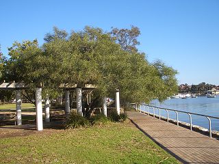
Belmore Park is a public park at the southern end of the Sydney central business district in the Australian state of New South Wales. Adjacent to the Central railway station, the park is bounded by Hay Street, Eddy Avenue, Elizabeth Street and Pitt Street. The area was previously known as Police Paddock and was part of a section of Crown land which included the Police Barracks, Devonshire Street Cemetery, Female Refuge of the Good Samaritan, Benevolent Asylum and a common.
The Inner West Light Rail is a 12.8-kilometre (8.0 mi) light rail line in Sydney, New South Wales, Australia, running from Central railway station through the Inner West to Dulwich Hill and serving 23 stops. The line is currently closed for investigations following cracks discovered on the LRVs. It is the original line of the Sydney light rail network, and was originally known as Sydney Light Rail. Light rail services on the line are now branded as the L1 Dulwich Hill Line.
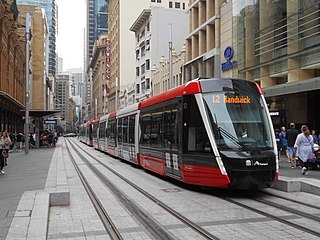
The CBD and South East Light Rail is a light rail line in Sydney, New South Wales, Australia. Construction commenced in October 2015, with services between Circular Quay and Randwick commencing on 14 December 2019 as the L2 Randwick Line, and between Circular Quay and Kingsford on 3 April 2020 as the L3 Kingsford Line. It is part of Sydney's light rail network.

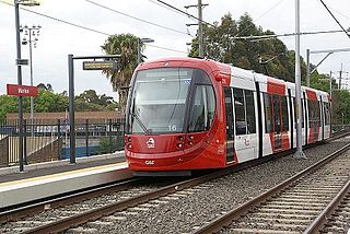
The Newcastle Light Rail is a light rail system in Newcastle, New South Wales, Australia, running from Newcastle Interchange through the central business district to Pacific Park. Major construction commenced in September 2017 and the line was opened on 17 February 2019. It is operated by Newcastle Transport for Transport for NSW.