Macquarie Street, Sydney

Last updated

Macquarie Street

Macquarie Street, 2011 (cropped).png
Central section of Macquarie Street, looking south (2011)
OSM central Sydney.png
Red pog.svg
Northern end
Red pog.svg
Southern end
Coordinates
General information
TypeStreet
Length1.2 km (0.7 mi)
Major junctions
Northern endNo through road
Bennelong Point, Sydney
 
Southern endPrince Albert Road
St James Road
Sydney CBD
Location(s)
LGA(s) City of Sydney
Major suburbs Sydney CBD

Macquarie Street is a street in the central business district of Sydney in New South Wales, Australia. Macquarie Street extends from Hyde Park at its southern end to the Sydney Opera House at its northern end. Apart from connecting these two major landmarks, the key government institutions of the state of New South Wales are all located on this street.

Contents

History

HydeParkBarracks.JPG
Hyde Park Barracks (completed 1819)
1 St James Church lighter.jpg
St James' Church (completed 1824)
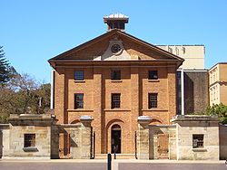
Two buildings preserved from the Macquarie era, located at the southern end of Macquarie Street.

Macquarie Street is named after Lachlan Macquarie, an early Governor of New South Wales (in office 1810–1821). [1] In the years since its founding in 1788, Sydney had developed organically, and by the early 1800s was lacking in major public buildings, and had a complex network of narrow streets. The supply of drinking water and waste management was also becoming an issue. Governor Macquarie initiated the construction of Sydney's first public buildings of any real permanence and set the boundaries of Sydney's grid of streets. With Circular Quay as the focus of this new civic scheme, Macquarie Street marked its eastern boundary and was designed as a ceremonial thoroughfare. [2] The public buildings distributed either side of the street would both delineate and connect the civil and commercial town centre to its west with the green spaces (now the Domain and Royal Botanic Gardens) to the east.

Among the public buildings commissioned by Macquarie, Hyde Park Barracks and St James' Church are two examples largely preserved from that era. The two buildings face each other across Queen's Square, at the southern end of Macquarie Street.

The Sydney Hospital, after rebuilding was completed in 1894. Sydney Hospital (3793508677).jpg
The Sydney Hospital, after rebuilding was completed in 1894.
The central section of Macquarie Street c.1900, looking south: the tall building on the right is the Colonial Secretary's Building, while on the left is the gate of the Royal Botanic Gardens leading to Government House and the Government House stables (now the Sydney Conservatorium of Music) Macquarie Street, Sydney from The Powerhouse Museum Collection.jpg
The central section of Macquarie Street c.1900, looking south: the tall building on the right is the Colonial Secretary's Building, while on the left is the gate of the Royal Botanic Gardens leading to Government House and the Government House stables (now the Sydney Conservatorium of Music)

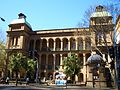
Upon laying out the street in 1810, Governor Macquarie also carved out land from the Domain for the building of Sydney Hospital, with its frontage on Macquarie Street. Due to the reluctance of the British government to provide funding, the building contract for the hospital provided for the government to provide convict labour, and for part of the project costs to be paid in the form of rum import monopolies, leading to the name the "Rum Hospital". The hospital buildings were completed in 1816. Although called "elegant and commodious" by some commentators, architect Francis Greenway criticised both the design and construction. [3] As the only major hospital in the colony at the time, the hospital took up almost the entire eastern frontage of the southern half of Macquarie Street. However, the hospital's capacity exceeded the needs of Sydney at the time, and almost from the start space in its two wing buildings began to be occupied by various government institutions. The northern wing building was occupied by the Legislative Council and Executive Council, and was eventually expanded to become the Parliament House for New South Wales. The southern wing building became the Sydney Mint, among other functions.

After Macquarie, subsequent governors and (after the establishment of responsible government in the colony) governments continued to regard Macquarie Street as the axis of an informal governmental and public precinct. The State Library of New South Wales, the Colonial Secretary's Building and the old Treasury Building, (now part of the InterContinental Hotel) are examples of such institutions. At the same time, as an elegant tree-lined boulevarde adjacent both to the commercial city centre and the green spaces of the Royal Botanic Gardens and the Domain, the street became Sydney's most pre-eminent residential address. [4] In particular, the close proximity to Sydney Hospital and court buildings attracted leading barristers and doctors to set up chambers and surgeries along the street. In 1977, the New South Wales government built a new Law Courts Building at Queen's Square at the southern end of the street, to house the Supreme Court of New South Wales and the Sydney registries of the Federal Court of Australia and the High Court of Australia.

Burdekin House, built in 1842 and described as the finest private residence in Sydney, was located on Macquarie Street. Its demolition became an early rallying point for the conservation movement in Sydney. St Stephen's Presbyterian Church was built in 1934 on the site of Burdekin House, after an earlier St Stephen's in Phillip Street was demolished for the creation of Martin Place. [5]

The Garden Palace, a grand building constructed for the Sydney International Exhibition in 1879, was located on Macquarie Street, but was destroyed by fire only a few years later. [6]

Fort Macquarie in 1870. Fort Macquarie ca.1870 from Sydney Streets and Buildings, 1861-ca.1900 chiefly by Kerry & Co..jpg
Fort Macquarie in 1870.

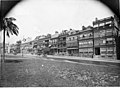
The northern section of Macquarie Street was initially a path through the Governor's Domain leading to Bennelong Point. After Government House was moved further up the hill, the path was widened and became part of Macquarie Street, leading to land to the west of the street being sold off for commercial development in the 1840s-1850s. Today, this northern section of Macquarie Street runs along the eastern side of Circular Quay. To the east of this northern section is the Royal Botanic Gardens, while to the west of the street, the historic sandstone Moore Stairs, built in 1868 leads to the waterfront. [7] In the past, this area was lined by warehouses and other shipping-related facilities focusing on the wool trade, leading to this section being called the "wool stores" end. In 1868 Moore Stairs were built to provide access between these stores down to East Circular Quay. [8] At the end of the street was Bennelong Point. From 1821 this was the site of Fort Macquarie, which in 1901 was demolished to make way for the Fort Macquarie Tram Depot, which was eventually demolished in 1958 to make way for the Sydney Opera House.

The warehouses and wharf facilities near the Opera House were progressively removed in the mid-20th century and replaced by modernist office blocks. In 1998, the Bennelong Apartments, a complex of contemporary buildings nicknamed "the Toaster", replaced the modernist office blocks. The complex includes private apartments, retail outlets, restaurants, the Pullman Quay Grand Hotel and a cinema.

"Harley Street of Sydney"

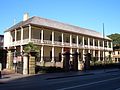
Because of the proliferation of medical chambers and surgeries, and the presence of a number of medical professional institutions, Macquarie Street was widely known as the Harley Street of Sydney from the late 19th century until recent decades. The Royal Australian College of Physicians Building [9] at 145 Macquarie Street was the Georgian residence of John Fairfax until 1848. The British Medical Association's 1920s BMA House [10] at 135–137 Macquarie Street still houses medical chambers and a lecture hall.

Government and public buildings

Government House, located within the Royal Botanic Gardens, entry is from Macquarie Street Sidney-Australia11.JPG
Government House, located within the Royal Botanic Gardens, entry is from Macquarie Street
Parliament House, near the southern terminus of Macquarie Street Parliament house sydney 2 blended exposures.jpg
Parliament House, near the southern terminus of Macquarie Street
Sydney Public Library, corner of Bent & Macquarie, Sydney, 1877. This building has since been demolished. A089193r (25180409795).jpg
Sydney Public Library, corner of Bent & Macquarie, Sydney, 1877. This building has since been demolished.

Macquarie Street is the location of the main governmental institutions of New South Wales: Parliament House, Government House, and the Law Courts Building (which houses the Supreme Court of New South Wales) are all located along the street. "Macquarie Street" is used as a metonym for the New South Wales government (the way Whitehall, for example, is a metonym for the British government).

Institutions of the Federal Government located along the street include the Sydney registries of the Federal Court of Australia and High Court of Australia, both in the Law Courts Building at Queen's Square, and the headquarters of the Reserve Bank of Australia.

Macquarie Street is also the location of Sydney Hospital, the Hyde Park Barracks and St. James' Church, which were all built during Governor Macquarie's tenure. The historic Sydney Mint building, along with the entrance building to Parliament House, are preserved remnants of the original Sydney Hospital.

The State Library of New South Wales is located on Macquarie Street, as are the historic Chief Secretary's Building and the old New South Wales Treasury (now part of the InterContinental Hotel). Within the Royal Botanic Gardens are Government House and the Sydney Conservatorium of Music, originally built as the Government House stables. At the northern terminus of Macquarie Street is the iconic Sydney Opera House.

Notable past residents

Cross streets and transportation

The southern end of Macquarie Street terminates at the northern edge of Hyde Park, where it meets St James' Road and Prince Alfred Road at Queen's Square, Sydney, to which Phillip Street and King Street also join. Other streets that cross or terminate on Macquarie Street, from south to north, are Martin Place, Hunter Street, Bent Street, Bridge Street, Conservatorium Road and Albert Street. The Cahill Expressway crosses Macquarie Street partly as an overpass and partly as a tunnel. The northern end of Macquarie Street is a roundabout near the Sydney Opera House at Bennelong Point.

St James railway station and Martin Place railway station on the Sydney Trains metropolitan rail network are located immediately adjacent to Macquarie Street, while Circular Quay railway station is located nearby.

Residential chambers 131 Macquarie st RESIDENTIAL CHAMBERS BEFORE HUDSON HOUSE 1907.jpg
Residential chambers 131 Macquarie st

See also

Australia road sign W5-29.svg   Australian Roadsportal

Related Research Articles

<span class="mw-page-title-main">Sydney Conservatorium of Music</span> Music faculty of the University of Sydney

The Sydney Conservatorium of Music is a heritage-listed music school in Macquarie Street, Sydney, New South Wales, Australia. It is one of the oldest and most prestigious music schools in Australia. Located adjacent to the Royal Botanic Gardens on the eastern fringe of the Sydney central business district, the conservatorium is a faculty of the University of Sydney, and incorporates the community-based Conservatorium Open Academy and the Conservatorium High School. In addition to its secondary, undergraduate, post-graduate and community education teaching and learning functions, the conservatorium undertakes research in various fields of music. The building was added to the New South Wales State Heritage Register on 14 January 2011.

<span class="mw-page-title-main">Hyde Park, Sydney</span> Park in Sydney, Australia

Hyde Park, Sydney, is an urban park, of 16.2-hectare (40-acre), located in the central business district of Sydney, in the City of Sydney local government area of New South Wales, Australia. It is the oldest public parkland in Australia. Hyde Park is on the eastern fringe of the Sydney city centre and is approximately rectangular in shape, being squared at the southern end and rounded at the northern end. It is bordered on the west by Elizabeth Street, on the east by College Street, on the north by St. James Road and Prince Albert Road and on the south by Liverpool Street.

<span class="mw-page-title-main">Circular Quay</span> Locality in Sydney, New South Wales, Australia

Circular Quay is a harbour, former working port and now international passenger shipping port, public piazza and tourism precinct, heritage area, and transport node located in Sydney, New South Wales, Australia on the northern edge of the Sydney central business district on Sydney Cove, between Bennelong Point and The Rocks. It is part of the local government area of the City of Sydney.

<span class="mw-page-title-main">Macquarie Place Park</span> Heritage-listed park in Sydney, Australia

The Macquarie Place Park, also known as the Macquarie Place Precinct, is a heritage-listed small triangular urban park located in the Sydney central business district in the City of Sydney local government area of New South Wales, Australia. The former town square and milestone and now memorial, public park and monument is situated on the corner of Bridge Street and Loftus Street. It is named in honour of Governor Lachlan Macquarie. The precinct includes The Obelisk or Macquarie Obelisk, the Sirius anchor and gun/cannon, the Statue of Thomas Sutcliffe Mort, the historic Underground Public Conveniences and the Christie Wright Memorial Fountain. The property was added to the New South Wales State Heritage Register on 5 March 2010.

<span class="mw-page-title-main">Sydney Hospital</span> Hospital in New South Wales, Australia

Sydney Hospital is a major hospital in Australia, located on Macquarie Street in the Sydney central business district. It is the oldest hospital in Australia, dating back to 1788, and has been at its current location since 1811. It first received the name Sydney Hospital in 1881.

<span class="mw-page-title-main">The Domain, Sydney</span> Park in Sydney, Australia

The Domain is a heritage-listed 34-hectare (84-acre) area of open space located on the eastern fringe of the Sydney central business district, in the City of Sydney local government area of New South Wales, Australia. Separating the central business district from Woolloomooloo, The Domain adjoins the Royal Botanic Gardens and is managed by the Royal Botanic Gardens Trust, a division of the NSW Office of Environment and Heritage, an agency of the Government of New South Wales. The Domain is used as a venue for outdoor concerts, open-air events, large political gatherings and rallies, as well as being used daily by the people of Sydney for exercise and relaxation. Along with the Royal Botanic Gardens, The Domain was added to the New South Wales State Heritage Register on 2 April 1999.

<span class="mw-page-title-main">Sydney central business district</span> Suburb of Sydney, New South Wales, Australia

The Sydney central business district (CBD) is the historical and main commercial centre of Sydney. The CBD is Sydney's city centre, or Sydney City, and the two terms are used interchangeably. Colloquially, the CBD or city centre is often referred to simply as "Town" or "the City". The Sydney city centre extends southwards for about 3 km (2 mi) from Sydney Cove, the point of first European settlement in which the Sydney region was initially established.

<span class="mw-page-title-main">Royal Botanic Garden, Sydney</span> Botanic gardens in Sydney, New South Wales, Australia

The Royal Botanic Garden, Sydney is a heritage-listed major 30-hectare (74-acre) botanical garden, event venue and public recreation area located at Farm Cove on the eastern fringe of the Sydney central business district, in the City of Sydney local government area of New South Wales, Australia.

<span class="mw-page-title-main">Sydney Mint</span> Heritage-listed building in Sydney

The Sydney Mint in Sydney, New South Wales, Australia, is the oldest surviving public building in the Sydney central business district. Built between 1811 and 1816 as the southern wing of the Sydney Hospital, it was then known as the Rum Hospital. In 1854 a mint was established on the site with the hospital building used to house mint staff as well as providing a residence for the Deputy Mint Master. A coining factory was built at the rear. Both of these structures have exceptional heritage significance and have been associated with major events in the colonial history of New South Wales.

<span class="mw-page-title-main">New South Wales Government Architect</span>

The New South Wales Government Architect, an appointed officer of the Government of New South Wales, serves as the General Manager of the Government Architect's Office (GAO), a multi-disciplinary consultancy operating on commercial principles providing architecture, design, and engineering services, that is an agency of the government within NSW Public Works.

<span class="mw-page-title-main">Hyde Park Barracks, Sydney</span> Heritage-listed building in Sydney, Australia

The Hyde Park Barracks, Sydney is a heritage-listed former barracks, hospital, convict accommodation, mint and courthouse and now museum and cafe located at Macquarie Street in the Sydney central business district, in the City of Sydney local government area of New South Wales, Australia. Originally built from 1811 to 1819 as a brick building and compound to house convict men and boys, it was designed by convict architect Francis Greenway. It is also known as the Mint Building and Hyde Park Barracks Group and Rum Hospital; Royal Mint – Sydney Branch; Sydney Infirmary and Dispensary; Queen's Square Courts; Queen's Square. The site is managed by the Sydney Living Museums, an agency of the Government of New South Wales, as a living history museum open to the public.

<span class="mw-page-title-main">Tourism in Sydney</span>

Tourism in Sydney, Australia forms an important part of the city's economy. The city received 12 million domestic visitors and 4.1 million international visitors in year ending June 2019. The most famous attractions include the Sydney Opera House, and the Sydney Harbour Bridge. Other attractions include the Sydney Mardi Gras, Royal Botanical Gardens, Luna Park, the beaches and Sydney Tower.

<span class="mw-page-title-main">Architecture of Sydney</span> Overview of the architecture in Sydney

The architecture of Sydney, Australia’s oldest city, is not characterised by any one architectural style, but by an extensive juxtaposition of old and new architecture over the city's 200-year history, from its modest beginnings with local materials and lack of international funding to its present-day modernity with an expansive skyline of high rises and skyscrapers, dotted at street level with remnants of a Victorian era of prosperity.

<span class="mw-page-title-main">Parliament House, Sydney</span> House of parliament for State of New South Wales, Australia

The Parliament House in Sydney is a heritage-listed complex of buildings housing the Parliament of the state of New South Wales, Australia. The building is located on the east side of Macquarie Street in Sydney, the state capital. The façade consists of a two-storey Georgian building, the oldest public building in the City of Sydney, flanked by two Neo-gothic additions containing the parliamentary chambers. These buildings are linked to a 1970s 12-storey block at the rear, facing onto the Domain. It is also known as Parliament of New South Wales, Parliamentary Precincts and the Rum Hospital.

<span class="mw-page-title-main">Bennelong Apartments</span>

The Bennelong Apartments is a residential apartment building and multi-use complex on the east side of Sydney's Circular Quay. The buildings were designed by Andrew Andersons and PTW Architects, and completed in 1998.

<span class="mw-page-title-main">Fort Macquarie</span>

Fort Macquarie was a square castellated battlement fort built in 1798 at Bennelong Point, Sydney, New South Wales, Australia, on the site where the Sydney Opera House now stands. It was demolished in 1901 to make way for the Fort Macquarie Tram Depot.

<span class="mw-page-title-main">Queen's Square, Sydney</span> Public square in Sydney, Australia

Queen's Square is a public square in central Sydney, Australia. The square is located at the junction of King Street with Phillip Street and Macquarie Street. It is bounded on the south by St James Road and Prince Albert Road.

<span class="mw-page-title-main">Outline of Sydney</span> Overview of and topical guide to Sydney

The following outline is provided as an overview of and topical guide to Sydney:

<span class="mw-page-title-main">Sydney Cove West Archaeological Precinct</span> Historic site in New South Wales, Australia

Sydney Cove West Archaeological Precinct is a heritage-listed precinct that contains The Rocks police station, the Museum of Contemporary Art Australia, car park, parks, shops and roads located at 112–156 George Street, in the inner city Sydney suburb of The Rocks in the City of Sydney local government area of New South Wales, Australia. The precinct previously contained a commissariat store, Maritime Services Board offices, dockyard and Department of Labour & Industry offices. Buildings in the precinct were developed in various stages since 1797 to date, with heritage-listed buildings dating from 1797 to 1939. The precinct is also known as the Museum of Contemporary Art, Maritime Services Board, Colonial Government naval dockyard, Commissariat Stores, Colonial Hospital, Kings and Queens Wharf and First Fleet Park. The property is owned by Property NSW, an agency of the Government of New South Wales. It was added to the New South Wales State Heritage Register on 5 August 2011.

<span class="mw-page-title-main">Moore Stairs</span> Heritage-listed flight of stairs in Sydney, Australia

The Moore Stairs, also known as Moore Steps, are a NSW heritage listed public access flight of stairs which connect East Circular Quay with Macquarie Street in Sydney, Australia. Constructed in 1868 of Melbourne bluestone, they were named in honour of the city's mayor Charles Moore, and remain in use.

References

  1. Munro, C. (15 September 2007). "Forever elegant on the street Lachlan built". The Sydney Morning Herald .
  2. "Macquarie Street". Dictionary of Sydney. Retrieved 31 October 2016.
  3. "Rum Hospital 1811 - 1854". The Mint. Historic Houses Trust. Archived from the original on 27 April 2006. Retrieved 17 August 2006.
  4. Dictionary of Sydney. "Macquarie Street" . Retrieved 31 October 2016.
  5. Mark Dunn (2008). "St Stephen's Presbyterian church Macquarie Street". Dictionary of Sydney. Dictionary of Sydney Trust. Retrieved 3 June 2016.
  6. "Garden Palace". Dictionary of Sydney. Retrieved 31 October 2016.
  7. Moore Stairs
  8. Preston, Jennifer (2018). "Moore Stairs". Dictionary of Sydney . Retrieved 23 April 2021.
  9. "Royal Australian College of Physicians Building (Place ID 1832)". Australian Heritage Database . Australian Government.
  10. "BMA House (Place ID 1831)". Australian Heritage Database . Australian Government.
Template:Attached KML/Macquarie Street, Sydney
KML is from Wikidata