Bennelong Point

Last updated

Bennelong Point
SydneyOpera House.JPG
OSM central Sydney.png
Red pog.svg
Bennelong Point
Coordinates: 33°51′24″S151°12′54″E / 33.8567°S 151.2150°E / -33.8567; 151.2150
Location Port Jackson, City of Sydney, Australia

Bennelong Point, a former island in Sydney Harbour, is a headland that, since the 1970s, is the location of the Sydney Opera House in Sydney, New South Wales, Australia.

Contents

History

Bennelong Point is known to the local Gadigal people of the Eora nation as Dubbagullee. [1]

The point was originally a small tidal island, Bennelong Island, that largely consisted of rocks with a small beach on the western side. The island was located on the tip of the eastern arm of Sydney Cove and was apparently separated from the mainland at high tide. For a brief period in 1788, this relatively isolated protrusion into Port Jackson (Sydney's natural harbour) was called Cattle Point as it was used to confine the few cattle and horses that had been brought from Cape Town by Governor Arthur Phillip with the First Fleet.

The area at that time was also strewn with discarded oyster shells from many long years of gathering by the local aboriginal women. Those shells were regathered by the newly arrived convict women and burnt to make lime for cement mortar. The point was called Limeburners' Point for that reason, though those shells only furnished enough lime to make a single building, the two-storey government house. [2]

In the early 1790s, the Aboriginal man Bennelong— employed as a cultural interlocutor by the British—persuaded New South Wales Governor Phillip to build a brick hut for him on the point, giving it its name.

In December 1798, a half-moon battery was constructed at the extreme northern end of the Point, mounted with guns from HMS Supply.

In the period from 1818 to 1821, the tidal area between Bennelong Island and the mainland was filled with rocks excavated from the Bennelong Point peninsula. The entire area was leveled to create a low platform and to provide suitable stone for the construction of Fort Macquarie. While the fort was being built, a large portion of the rocky escarpment at Bennelong Point was also cut away to allow a road to be built around the point from Sydney Cove to Farm Cove. This was known as Tarpeian Way.

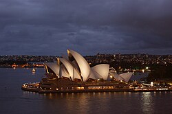
The existence of the original tidal island and its rubble fill were largely forgotten until the late 1950s when both were rediscovered during the excavations related to the construction of the Sydney Opera House. Prior to the Opera House's construction, Bennelong Point had housed Fort Macquarie Tram Depot. There is no proof in original documents or maps to this 'tidal island' off Bennelong Point.

See also

Related Research Articles

<span class="mw-page-title-main">Bennelong</span> Australian Eora interlocutor with the British (c. 1764 – 1813)

Woollarawarre Bennelong, also spelt Baneelon, was a senior man of the Eora, an Aboriginal Australian people of the Port Jackson area, at the time of the first British settlement in Australia in 1788. Bennelong served as an interlocutor between the Eora and the British, both in the colony of New South Wales and in the United Kingdom.

<span class="mw-page-title-main">Port Jackson</span> Body of water in Sydney, Australia

Port Jackson, consisting of the waters of Sydney Harbour, Middle Harbour, North Harbour and the Lane Cove and Parramatta Rivers, is the ria or natural harbour of Sydney, New South Wales, Australia. The harbour is an inlet of the Tasman Sea. It is the location of the Sydney Opera House and Sydney Harbour Bridge. The location of the first European settlement and colony on the Australian mainland, Port Jackson has continued to play a key role in the history and development of Sydney.

<span class="mw-page-title-main">Sydney Cove</span> Bay in Sydney Harbour, Australia

Sydney Cove is a bay on the southern shore of Sydney Harbour, one of several harbours in Port Jackson, on the coast of Sydney, New South Wales. Sydney Cove is a focal point for community celebrations, due to its central Sydney location between the Sydney Opera House and the Sydney Harbour Bridge.

<span class="mw-page-title-main">Circular Quay</span> Locality in Sydney, New South Wales, Australia

Circular Quay is a harbour, former working port and now international passenger shipping terminal, public piazza and tourism precinct, heritage area, and transport node located in Sydney, New South Wales, Australia on the northern edge of the Sydney central business district on Sydney Cove, between Bennelong Point and The Rocks. It is part of the local government area of the City of Sydney.

<span class="mw-page-title-main">Tidal island</span> Island accessible by foot at low tide

A tidal island is a raised area of land within a waterbody, which is connected to the larger mainland by a natural isthmus or man-made causeway that is exposed at low tide and submerged at high tide, causing the land to switch between being a promontory/peninsula and an island depending on tidal conditions.

<span class="mw-page-title-main">The Domain, Sydney</span> Park in Sydney, Australia

The Domain is a heritage-listed 34-hectare (84-acre) area of open space located on the eastern fringe of the Sydney central business district, in the City of Sydney local government area of New South Wales, Australia. Separating the central business district from Woolloomooloo, The Domain adjoins the Royal Botanic Gardens and is managed by the Royal Botanic Gardens Trust, a division of the NSW Office of Environment and Heritage, an agency of the Government of New South Wales. The Domain is used as a venue for outdoor concerts, open-air events, large political gatherings and rallies, as well as being used daily by the people of Sydney for exercise and relaxation. Along with the Royal Botanic Gardens, The Domain was added to the New South Wales State Heritage Register on 2 April 1999.

<span class="mw-page-title-main">Macquarie Street, Sydney</span> Street in Sydney, Australia

Macquarie Street is a street in the central business district of Sydney in New South Wales, Australia. Macquarie Street extends from Hyde Park at its southern end to the Sydney Opera House at its northern end. Apart from connecting these two major landmarks, the key government institutions of the state of New South Wales are all located on this street.

<span class="mw-page-title-main">Eora</span> Aboriginal Australian nation of New South Wales

The Eora are an Aboriginal Australian people of New South Wales. Eora is the name given by the earliest European settlers to a group of Aboriginal people belonging to the clans along the coastal area of what is now known as the Sydney basin, in New South Wales, Australia. The Eora share a language with the Darug people, whose traditional lands lie further inland, to the west of the Eora.

<span class="mw-page-title-main">Macquarie Lighthouse</span> Lighthouse in New South Wales, Australia

The Macquarie Lighthouse, also known as South Head Upper Light, is the first, and is the longest serving, lighthouse site in Australia. It is located on Dunbar Head, on Old South Head Road, Vaucluse in the Municipality of Woollahra local government area of New South Wales, Australia. The lighthouse is situated approximately 2 kilometres (1 mi) south of South Head near the entrance to Sydney Harbour. There has been a navigational aid in this vicinity since 1791 and a lighthouse near the present site since 1818. The current heritage-listed lighthouse was completed in 1883. The lighthouse and associated buildings were designed by James Barnet and built from 1881 to 1883.

<span class="mw-page-title-main">Sydney central business district</span> Suburb of Sydney, New South Wales, Australia

The Sydney central business district (CBD) is the historical and main commercial centre of Sydney. The CBD is Sydney's city centre, or Sydney City, and the two terms are used interchangeably. Colloquially, the CBD or city centre is often referred to simply as "Town" or "the City". The Sydney city centre extends southwards for about 3 km (2 mi) from Sydney Cove, the point of first European settlement in which the Sydney region was initially established.

<span class="mw-page-title-main">Royal Botanic Garden, Sydney</span> Botanic gardens in Sydney, New South Wales, Australia

The Royal Botanic Garden, Sydney is a heritage-listed major 30-hectare (74-acre) botanical garden, event venue and public recreation area located at Farm Cove on the eastern fringe of the Sydney central business district, in the City of Sydney local government area of New South Wales, Australia.

<span class="mw-page-title-main">Farm Cove, New South Wales</span>

Farm Cove is a tidal inlet and shallow bay in Sydney Harbour, separated from Sydney Cove by Bennelong Point, New South Wales, Australia. Farm Cove is one of the places around Sydney Harbour that has been officially gazetted as a dual named site by the Geographical Names Board (GNB). The official dual name for this place is: 'Farm Cove / Wahganmuggalee'.

<span class="mw-page-title-main">Fort Macquarie Tram Depot</span>

Fort Macquarie Tram Depot was part of the Sydney tram network. It opened in 1902 on the site of the old Fort Macquarie and was demolished in 1958 to make way for the construction of the Sydney Opera House.

<span class="mw-page-title-main">Mrs Macquarie's Chair</span> Sandstone rock in Sydney Harbour

Mrs Macquarie's Chair is an exposed sandstone rock cut into the shape of a bench, on a peninsula in Sydney Harbour. It was hand carved by convicts in 1810, for Elizabeth Macquarie, the wife of Major-General Lachlan Macquarie, Governor of New South Wales. The peninsula itself was known to the Gadigal as Yurong Point, and is now widely known as Mrs Macquarie's Point, and is part of The Domain, near the Royal Botanic Gardens.

<span class="mw-page-title-main">Bennelong Apartments</span> Residential apartment building and multi-use complex in Sydney, Australia

The Bennelong Apartments is a residential apartment building and multi-use complex on the east side of Sydney's Circular Quay. The buildings were designed by Andrew Andersons and PTW Architects, and completed in 1998.

<span class="mw-page-title-main">Dawes Point Battery</span> Historic site in New South Wales, Australia

The Dawes Point Battery remains is a heritage-listed former artillery fortification and now visitor attraction located adjacent to the southern pylon of the Sydney Harbour Bridge at Hickson Road in inner city Sydney, on the boundary between Dawes Point and The Rocks in the City of Sydney local government area of New South Wales, Australia. It was built and modified from 1791 to 1925 by Lieutenant William Dawes, Robert Ross, Francis Greenway, and George Barney. The property is owned by Property NSW, an agency of the Government of New South Wales. It was added to the New South Wales State Heritage Register on 10 May 2002.

<span class="mw-page-title-main">Fort Macquarie</span>

Fort Macquarie was a square castellated battlement fort built in 1798 at Bennelong Point, Sydney, New South Wales, Australia, on the site where the Sydney Opera House now stands. It was demolished in 1901 to make way for the Fort Macquarie Tram Depot.

<span class="mw-page-title-main">Sydney punchbowls</span> Chinese porcelain with scenes of Sydney

The Sydney punchbowls, made in China during the Jiaqing Emperor's reign (1796–1820) over the mid-Qing dynasty, are the only two known examples of Chinese export porcelain hand painted with Sydney scenes and dating from the Macquarie era. The bowls were procured in Canton about three decades after the First Fleet's arrival at Port Jackson where the British settlement at Sydney Cove was established in 1788. They also represent the trading between Australia and China via India at the time. Even though decorated punchbowls were prestigious items used for drinking punch at social gatherings during the 18th and 19th centuries, it is not known who originally commissioned these bowls or what special occasion they were made for.

<span class="mw-page-title-main">Outline of Sydney</span> Overview of and topical guide to Sydney

The following outline is provided as an overview of and topical guide to Sydney:

<span class="mw-page-title-main">Man O'War Steps</span> Historic site in New South Wales, Australia

The Man O'War Steps is a heritage-listed jetty located at Farm Cove Crescent, in the Sydney central business district, in the City of Sydney local government area of New South Wales, Australia. It was built from 1810. The property is owned by Transport for NSW. It was added to the New South Wales State Heritage Register on 18 April 2000. The Steps are located on the eastern bank of Bennelong Point, adjacent to the Sydney Opera House and on the north-western boundary of the Royal Botanic Garden.

References

  1. "Bennelong Point / Dubbagullee". sydneybarani.com.au. City of Sydney. Retrieved 20 September 2018.
  2. Hughes, Robert (1987). The Fatal Shore (paperback 1996). p. section 1.iii (page 11), and section 4.ii (page 90). ISBN   1-86046-150-6.