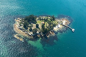
Shark Island (Port Jackson)

Last updated

Shark Island seen from Nielsen Park Shark Island, situated at the mouth of Rose Bay, New South Wales - Harb0024.jpg
Shark Island seen from Nielsen Park
Cricketer and Australian rules footballer George Coulthard was attacked by a shark off Shark Island in 1877. George Coulthard.jpg
Cricketer and Australian rules footballer George Coulthard was attacked by a shark off Shark Island in 1877.

Shark Island is an island located with in Sydney Harbour, in New South Wales, Australia. The island is 1.5 hectares (3.7 acres) in area, [1] measuring some 250 metres by 100 metres, and lies off the Sydney suburbs of Point Piper, Rose Bay and Vaucluse, in the eastern section of the harbour between the Harbour Bridge and the harbour entrance. The island was known by the local Aboriginal people as Boambilly, [2] and the current name comes from its shape, which is claimed to resemble a shark. [3]

Contents

The island has been the site of drownings, shipwrecks, and at least one shark attack, when, in 1877, Australian rules footballer and cricketer George Coulthard was sitting in a boat anchored offshore and was pulled overboard by a large shark. Coulthard managed to return to the boat, his attack and escape were widely reported.

Parts of the island were set aside as a recreation reserve as early as 1879 and it was also used as an animal quarantine station and naval depot until 1975. At that time it became exclusively a recreation reserve and part of the Sydney Harbour National Park. Approved operators and a scheduled ferry service can take people to the island. [4] [5] [6]

Shark Island Light is an active pile lighthouse located just north of Shark Island, an island in Sydney Harbour, New South Wales, Australia. Its light is only visible on in the fairway of the harbour, between Shark Point and Point Piper. [7]

Contents

See also

Related Research Articles

Darling Harbour

Darling Harbour is a harbour adjacent to the city centre of Sydney, New South Wales, Australia that is made up of a large recreational and pedestrian precinct that is situated on western outskirts of the Sydney central business district.

Sydney Harbour National Park Protected area in New South Wales, Australia

The Sydney Harbour National Park is an Australian national park comprising parts of Port Jackson, Sydney and its foreshores and various islands. The 392-hectare (970-acre) national park lies in New South Wales and was created progressively, from 1975.

Port Jackson Body of water in Sydney, Australia

Port Jackson, consisting of the waters of Sydney Harbour, Middle Harbour, North Harbour and the Lane Cove and Parramatta Rivers, is the ria or natural harbour of Sydney, New South Wales, Australia. The harbour is an inlet of the Tasman Sea. It is the location of the Sydney Opera House and Sydney Harbour Bridge. The location of the first European settlement and colony on the Australian mainland, Port Jackson has continued to play a key role in the history and development of Sydney.

Rose Bay, New South Wales Suburb of Sydney, New South Wales, Australia

Rose Bay is a harbourside, eastern suburb of Sydney, in the state of New South Wales, Australia. Rose Bay is located seven kilometres east of the Sydney central business district, in the local government areas of Waverley Council and Municipality of Woollahra.

Palm Beach, New South Wales Suburb of Sydney, New South Wales, Australia

Palm Beach is a suburb in the Northern Beaches region of Sydney, in the state of New South Wales, Australia. Palm Beach is located 41 kilometres (25 mi) north of the Sydney central business district, in the local government area of Northern Beaches Council. Palm Beach sits on a peninsula at the end of Barrenjoey Road, between Pittwater and Broken Bay. The population of Palm Beach was 1,593 as at the 2016 census.

Greenwich, New South Wales Suburb of Sydney, New South Wales, Australia

Greenwich is a suburb on the Lower North Shore of Sydney, in the state of New South Wales, Australia. Greenwich is located 7 kilometres (4.3 mi) north-west of the Sydney central business district, in the local government area of the Municipality of Lane Cove.

Manly, New South Wales Suburb of Sydney, New South Wales, Australia

Manly is a beach-side suburb of northern Sydney, in the state of New South Wales, Australia. It is 17 kilometres (11 mi) north-east of the Sydney central business district and is currently one of the three administrative centres of the local government area of Northern Beaches Council. Manly has a long-standing reputation as a tourist destination, owing to its attractive setting on the Pacific Ocean and easy accessibility by ferry.

Double Bay, New South Wales Suburb of Sydney, New South Wales, Australia

Double Bay is a harbourside eastern suburb of Sydney, in the state of New South Wales, Australia 4 kilometres east of the Sydney central business district. It is the administrative centre of the local government area of the Municipality of Woollahra.

Vaucluse, New South Wales Suburb of Sydney, New South Wales, Australia

Vaucluse is an eastern suburb of Sydney, in the state of New South Wales, Australia. It is located 8 kilometres (5 mi) north-east of the Sydney central business district, in the local government areas of Waverley Council and the Municipality of Woollahra.

Rodd Point Suburb of Sydney, New South Wales, Australia

Rodd Point is a suburb in the Inner West of Sydney, in the state of New South Wales, Australia. It is 9 kilometres west of the Sydney central business district in the local government area of the City of Canada Bay.

Little Bay, New South Wales Suburb of Sydney, New South Wales, Australia

Little Bay is a suburb in south-eastern Sydney, in the state of New South Wales, Australia. Little Bay is located 14 kilometres south-east of the Sydney central business district and is part of the local government area of the City of Randwick.

Sydney Heads headlands around Sydney Harbour

The Sydney Heads are a series of headlands that form the 2 km (1.2 mi) wide entrance to Sydney Harbour in Sydney, New South Wales, Australia. North Head and Quarantine Head are to the north; South Head and Dunbar Head are to the south; and Middle Head, Georges Head, and Chowder Head are to the west and within the harbour. The Heads are contained within the Sydney Harbour National Park.

Montague Island (Australia) Protected area in New South Wales, Australia

Montague Island, known as Barunguba by the Yuin peoples, is a continental island contained within the Montague Island Nature Reserve, a protected nature reserve that is located offshore from the South Coast region of New South Wales, in eastern Australia. The nearest town located onshore from the 81-hectare (200-acre) reserve and island is Narooma, situated approximately 9 kilometres (5.6 mi) to the northwest.

Bradleys Head

Bradleys Head is a headland protruding from the north shore of Sydney Harbour, within the metropolitan area of Sydney, New South Wales, Australia. It is named after the First Fleet naval officer William Bradley. The original Aboriginal inhabitants belonged to the Borogegal clan of the Eora nation, and was known as Borogegy, Booraghee, Booragy or Burrogy. Also on the headland is an active lighthouse, Bradleys Head Light, constructed in 1905.

Clark Island, New South Wales

Clark Island is a small island in Sydney Harbour, near the coast of New South Wales, Australia. The island is part of the Sydney Harbour National Park and lies offshore the Sydney suburb of Darling Point, in the eastern part of Sydney Harbour between the Harbour Bridge and the harbour entrance.

State Dockyard

The State Dockyard was a ship building and maintenance facility operated by the Government of New South Wales in Carrington, Newcastle, New South Wales, Australia between 1942 and 1987.

Wentworth Point, New South Wales Suburb of Sydney, New South Wales, Australia

Wentworth Point is a suburb of Sydney, in the state of New South Wales, Australia. It is located 13 kilometres west of the Sydney central business district, on the eastern edge of the local government area of City of Parramatta. It is on the western shore of Homebush Bay on the southern side of the Parramatta River. Wentworth Point is usually regarded as part of the Greater Western Sydney region, including in administrative contexts, but it is also regarded as part of the Inner West region of Sydney in some contexts, especially commercial contexts.

Bradleys Head Light Lighthouse in New South Wales, Australia

The Bradleys Head Light is an active heritage-listed lighthouse located at Bradleys Head, a headland protruding from the north shore of Sydney Harbour, within Mosman, Mosman Council, Sydney, New South Wales, Australia. It is the sibling of Robertson Point Light. The site is owned by the NSW National Parks and Wildlife Service, an agency of the Government of New South Wales; while the light is managed by Sydney Ports Corporation. It was added to the New South Wales State Heritage Register on 18 April 2000.

Fort Denison Light Lighthouse in New South Wales, Australia

Fort Denison Light, also known as Pinchgut Light, is an active lighthouse located on top of a Martello Tower at Fort Denison, a former penal site and defensive facility occupying a small island in Sydney Harbour, New South Wales, Australia. The island is located downstream from the Harbour Bridge near Potts Point and the Royal Botanic Gardens. The fort is also known as "Pinchgut" lending its name to the light.

Shark Island Light Lighthouse in New South Wales, Australia

Shark Island Light is an active pile lighthouse located just north of Shark Island, an island in Sydney Harbour, New South Wales, Australia. Its light is only visible on in the fairway of the harbour, between Shark Point and Point Piper.

References

  1. "Sydney Harbour National Park Shark Island". National Parks and Wildlife Service. NSW Government. Retrieved 14 September 2014.
  2. Shark Island, Dictionary of Sydney. Retrieved 6 June 2016.
  3. Sydney Harbour National Park - Park Maps Archived 2007-02-08 at the Wayback Machine , New South Wales Department of Infrastructure, Planning and Natural Resources (as at 9 September 2005)
  4. Sydney Harbour National Park Culture & history Archived 2005-08-30 at the Wayback Machine , National Parks and Wildlife Service (as at 21 March 2006)
  5. New weekend ferry service for Sydney Harbour's Shark Island Archived 2007-10-11 at the Wayback Machine , National Parks and Wildlife Service press release 11 April 2003
  6. David Messent (1994). The Complete Guide to Sydney Harbour, ISBN   0-646-17888-1, page 130.
  7. Searle, Garry. "List of Lighthouses - New South Wales". Lighthouses of Australia. SeaSide Lights.

Coordinates: 33°51′30.08″S151°15′27.50″E / 33.8583556°S 151.2576389°E / -33.8583556; 151.2576389