Anzac Bridge

Last updated

Anzac Bridge
2019-04-10 ANZAC Bridge.jpg
Aerial view of the bridge
Coordinates 33°52′10″S151°11′09″E / 33.869340°S 151.185780°E / -33.869340; 151.185780
Carries Western Distributor AUS Alphanumeric Route A4.svg
CrossesJohnstons Bay
Locale Sydney, New South Wales, Australia
Begins Pyrmont (east)
Ends Glebe Island / Rozelle (west)
Other name(s)New Glebe Island Bridge
Named for Australian and New Zealand Army Corps
Owner Transport for NSW
Characteristics
Design Cable-stayed
MaterialConcrete and steel
Pier construction Reinforced concrete
Total length805 metres (2,641 ft)
Width32.2 metres (106 ft)
Longest span345 metres (1,132 ft)
Piers in water2
No. of lanes 8; plus grade-separated shared footpath and cycleway
History
Contracted lead designer Roads & Traffic Authority
Constructed by Baulderstone
Construction costA$170 million
Opened3 December 1995 (1995-12-03)
Replaces Glebe Island Bridge
Location
Anzac Bridge
References
[1] [2]

The Anzac Bridge is an eight-lane cable-stayed bridge that carries the Western Distributor (A4) across Johnstons Bay between Pyrmont and Glebe Island (part of the suburb of Rozelle), on the western fringe of the Sydney central business district, New South Wales, Australia. The bridge forms part of the road network leading from the central business district, the Sydney Harbour Bridge, and Cross City Tunnel to the Inner West and Northern Suburbs.

Contents

History

Glebe Island Bridges

There were two bridges over Johnstons Bay before the construction of the Anzac Bridge.

The first bridge was constructed as part of a project to move the abattoirs out of central Sydney, and to construct public abattoirs at Glebe Island. [3] The first pile of the original bridge was driven in October 1860. [4] The bridge was opened in 1862 and was a timber beam bridge 318.6 metres (1,045 feet 5 inches) long and 8.5 m (28 ft) wide with a 12 m (40 ft) swing section on the eastern side. It replaced a double steam punt crossing. [4]

The second Glebe Island Bridge was an electrically operated swing bridge opened in 1903, the year after the opening of the new Pyrmont Bridge over Sydney's Darling Harbour, which has a similar design. The bridge was designed by Percy Allan of the New South Wales Public Works Department who also designed the Pyrmont Bridge. Delays due to increasing traffic, which were exacerbated by having to close a major arterial road to allow the movement of shipping into Blackwattle Bay, led to the construction of the present-day Anzac Bridge. The 1903 bridge is still standing, but there is no access to pedestrians or vehicular traffic.

Anzac Bridge

The stay cable design concept development and final design for the new bridge were carried out by a team from the Roads & Traffic Authority, led by their Chief Bridge Engineer Ray Wedgwood and the construction by Baulderstone. [5] The bridge was opened to traffic on 3 December 1995 as the Glebe Island Bridge. [6]

The bridge was given its current name on Remembrance Day in 1998 [7] to honour the memory of the soldiers of the Australian and New Zealand Army Corps (known as Anzacs) who served in World War I. An Australian Flag flies atop the eastern pylon and a New Zealand Flag flies atop the western pylon. A bronze memorial statue of an Australian Anzac soldier ("digger") holding a Lee–Enfield rifle in the "rest on arms reverse" drill position was placed on the western end of the bridge on Anzac Day in 2000. A statue of a New Zealand soldier was added to a plinth across the road from the Australian Digger, facing towards the east, and was unveiled by Prime Minister of New Zealand Helen Clark in the presence of Premier of New South Wales Morris Iemma on Sunday 27 April 2008. [8]

Description

The bridge is 32.2 m (105 ft 8 in) wide and the main span is 345 m (1,132 ft) long. The reinforced concrete pylons are 120 m (390 ft) high [9] and support the deck by two planes of stay cables. Initially the stay cables were plagued by vibrations which have since been resolved by the addition of thin stabilising cables between the stay cables. [10]

There is a grade-separated shared pedestrian footpath and cycleway located on the northern side of the bridge, making possible a walk from Glebe Point Road, down Bridge Road, over the bridge and round Blackwattle Bay back to Glebe Point Road.[ citation needed ]

The bridge can carry a maximum of 180,000 cars per day. It reached its maximum capacity in 2002, only seven years after it was finished and consistent with the principles of induced demand of traffic.[ citation needed ]

The bridge is regularly patrolled by security guards as a counter-terrorist attack measure. Security cameras also monitor the walkway.[ citation needed ]

The bridge has a speed limit of 60 kilometres per hour (37 miles per hour): it was reduced from 70 km/h (43 mph) in January 2005. [11] Also prior to that date, the bridge had seven traffic lanes (4 eastbound, 3 westbound).

Originally, there were bus stops at the western end of the bridge, but they were removed because buses pulling out from the stops created a hazard as they merged with other traffic moving at (or close to) the speed limit. The Australian Anzac statue on the northern side of the bridge is adjacent to the former city-bound bus stop; the New Zealand Anzac statue was installed within the ramp area of the former stop on the southern side.

ANZAC Bridge from Blackwattle Bay ferry wharf.jpg
Panoramic view from Blackwattle Bay ferry wharf, Glebe, with F10 ferry Me-Mel

The bridge has been used in a number of artistic works including:

See also

Related Research Articles

<span class="mw-page-title-main">Sydney Harbour Bridge</span> Bridge across Sydney Harbour in Australia

The Sydney Harbour Bridge is a steel through arch bridge in Sydney, New South Wales, Australia, spanning Sydney Harbour from the central business district (CBD) to the North Shore. The view of the bridge, the harbour, and the nearby Sydney Opera House is widely regarded as an iconic image of Sydney, and of Australia itself. Nicknamed "The Coathanger" because of its arch-based design, the bridge carries rail, vehicular, bicycle and pedestrian traffic.

<span class="mw-page-title-main">Port Jackson</span> Body of water in Sydney, Australia

Port Jackson, consisting of the waters of Sydney Harbour, Middle Harbour, North Harbour and the Lane Cove and Parramatta Rivers, is the ria or natural harbour of Sydney, New South Wales, Australia. The harbour is an inlet of the Tasman Sea. It is the location of the Sydney Opera House and Sydney Harbour Bridge. The location of the first European settlement and colony on the Australian mainland, Port Jackson has continued to play a key role in the history and development of Sydney.

<span class="mw-page-title-main">Sydney Harbour Tunnel</span> Motorway tunnel in Sydney, Australia

The Sydney Harbour Tunnel is a twin-tube road tunnel in Sydney, Australia. The tunnel was completed and opened to traffic in August 1992 to provide a second vehicular crossing of Sydney Harbour to alleviate congestion on the Sydney Harbour Bridge. It is one of two transportation tunnels under the harbour, the other being a set of rail tunnels for the Sydney Metro.

<span class="mw-page-title-main">Pyrmont, New South Wales</span> Suburb of Sydney, New South Wales, Australia

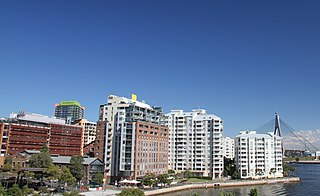
Pyrmont is an inner-city suburb of Sydney, in the state of New South Wales, Australia 2 kilometres south-west of the Sydney central business district in the local government area of the City of Sydney. It is also part of the Darling Harbour region. As of 2011, it is Australia's most densely populated suburb.

<span class="mw-page-title-main">Ultimo, New South Wales</span> Suburb of Sydney, New South Wales, Australia

Ultimo is an inner-city suburb of Sydney, New South Wales, Australia. It is adjacent to the Sydney central business district in the local government area of the City of Sydney west of the Darling Harbour area, and is bordered by Pyrmont to the north, the Sydney CBD and Chinatown/Haymarket to the east, Broadway and Chippendale to the south, and Glebe and Wentworth Park to the west.

<span class="mw-page-title-main">Pyrmont Bridge</span> Heritage-listed bridge across Cockle Bay in Sydney, Australia

The Pyrmont Bridge, a heritage-listed swing bridge across Cockle Bay, is located in Darling Harbour, part of Port Jackson, west of the central business district in the City of Sydney local government area of New South Wales, Australia. Opened in 1902, the bridge initially carried motor vehicle traffic via the Pyrmont Bridge Road between the central business district and Pyrmont. Since 1981 the bridge has carried pedestrian and bicycle traffic only, as motor vehicles were diverted to adjacent freeway overpasses. The bridge was added to the New South Wales State Heritage Register on 28 June 2002, the centenary of its opening.

<span class="mw-page-title-main">Glebe Island Bridge</span> Swing Allan truss road bridge in Sydney, Australia

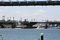
The Glebe Island Bridge is a heritage-listed disused swing Allan truss road bridge that carried Victoria Road across Rozelle Bay, located in the inner city Sydney suburb of Pyrmont in the City of Sydney local government area of New South Wales, Australia. The bridge, that connected Rozelle to Pyrmont by road, is one of the last remaining swing bridges of its type in Australia and in the world. It was designed by Percy Allan and built from 1899 to 1903 by Bridges Branch of NSW Public Works Department. It is also known as RMS Bridge No. 61. It was added to the New South Wales State Heritage Register on 29 November 2013 and was listed on the Register of the National Estate on 19 April 1989.

<span class="mw-page-title-main">White Bay (New South Wales)</span>

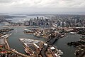
White Bay is a bay on Sydney Harbour with a surrounding locality near the suburbs of Balmain and Rozelle in the Inner West of Sydney, New South Wales, Australia.

<span class="mw-page-title-main">Tarban Creek Bridge</span> Bridge in New South Wales, Australia

The Tarban Creek Bridge is a prestressed concrete arch bridge that carries the Burns Bay Road across the Tarban Creek, located west of the Sydney central business district in New South Wales, Australia. The bridge is situated between the Gladesville Bridge and the Fig Tree Bridge, being immediately to the north of Gladesville Bridge. The bridge connects the suburbs of Hunters Hill and Huntleys Point. In addition to the four-lane carriage, the bridge carries a grade-separated shared pedestrian footpath and cycleway.

<span class="mw-page-title-main">Fig Tree Bridge</span> Bridge in New South Wales, Australia

The Fig Tree Bridge is a road bridge that carries Burns Bay Road across the Lane Cove River, and connects the suburbs of Hunters Hill in the south and Linley Point in the north, located approximately seven kilometres northwest of the central business district of Sydney in New South Wales, Australia. The concrete girder bridge carries motor vehicles, and a grade-separated footpath and cycleway.

<span class="mw-page-title-main">Sydney Freight Network</span> Railway line in Sydney, New South Wales, Australia

The Sydney Freight Network is a network of dedicated railway lines for freight in Sydney, Australia, linking the state's rural and interstate rail network with the city's main yard at Enfield and Port Botany. Its primary components are the Southern Sydney Freight Line (SSFL) and a line from Sefton to Enfield and Port Botany. The Network has been managed by the Australian Rail Track Corporation (ARTC) since 2012. Prior to the completion of the SSFL, it was managed by RailCorp as the Metropolitan Freight Network.

<span class="mw-page-title-main">Western Distributor (Sydney)</span> Motorway in New South Wales, Australia

Western Distributor is a 4.3-kilometre-long (2.7 mi) grade-separated motorway that is primarily elevated for the majority of its route on the western fringe of the Sydney central business district in New South Wales, Australia. It links the southern end of Bradfield Highway at the Sydney Harbour Bridge to Victoria Road in Rozelle, at its western terminus near White Bay. It is a constituent part of the A4 route.

<span class="mw-page-title-main">Victoria Road, Sydney</span> Road in Sydney, Australia

Victoria Road is a major road in Sydney, New South Wales, Australia, connecting Parramatta with Rozelle and is currently one of the longest roads in Sydney. The road passes over two major bridges: the Iron Cove Bridge over Iron Cove, and the Gladesville Bridge over the Parramatta River.

<span class="mw-page-title-main">Glebe Island</span>

Glebe Island was a major port facility in Sydney Harbour and, in association with the adjacent White Bay facility, was the primary receiving venue for imported cars and dry bulk goods in the region until 2008. It is surrounded by White, Johnstons, and Rozelle Bays. Whilst retaining its original title as an "island", it has long been infilled to the shoreline of the suburb of Rozelle and connected by the Glebe Island Bridge to Pyrmont.
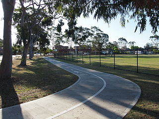
<span class="mw-page-title-main">Blackwattle Bay</span> Bay in Sydney Harbour, Sydney, New South Wales, Australia

Blackwattle Bay is a bay located to the south–east of Glebe Island and east of Rozelle Bay on Sydney Harbour, in New South Wales, Australia. The bay was named in 1788 after the Black Wattle tree found at the bay, which was used for housing construction.

<span class="mw-page-title-main">Pyrmont and Glebe railway tunnels</span>

The Pyrmont and Glebe railway tunnels are heritage-listed railway tunnels, once part of the Metropolitan Goods railway line, Pyrmont and Glebe, New South Wales, Australia. The tunnels now carry the Inner West Light Rail line. The property is owned by Transport Asset Holding Entity, a state government agency. The tunnels were added to the New South Wales State Heritage Register on 2 April 1999.

<span class="mw-page-title-main">Glebe and Wentworth Park railway viaducts</span> Bridge in New South Wales, Australia

The Glebe and Wentworth Park railway viaducts are a series of two heritage-listed railway bridges and arch viaducts that carry the Inner West Light Rail across Wentworth Park, Jubilee Park, and Johnstons Creek in the inner western Sydney suburb of Glebe in the City of Sydney local government area of New South Wales, Australia. They were designed by the New South Wales Government Railways and built from 1892 to 1922 by day labour. They are also known as Wentworth Park Viaduct, Jubilee Park Viaduct and Glebe Viaducts. The viaducts were added to the New South Wales State Heritage Register on 2 April 1999.

Darling Harbour Yard was a goods railway yard in Darling Harbour, New South Wales, Australia. The yard was once the origin of all outgoing goods traffic from Sydney. It was one of two major yards on the former Metropolitan Goods line, the other being in Rozelle. After closing to heavy rail in 1993, the alignment of the Metropolitan Goods line which passed through it was reutilised by light rail. The precinct around the yard was significantly redeveloped in the decades following its closure.

<span class="mw-page-title-main">Ray Wedgwood</span> Australian civil and bridge engineer (1942-2020)

Raymond John Lloyd Wedgwood was an Australian engineer who served as the Chief Bridge Engineer of the Department of Main Roads and the Roads & Traffic Authority in New South Wales. He designed and supervised the construction of many major bridges across New South Wales and led the design team for the cable stayed Anzac Bridge in Sydney. He also played a pivotal role in the development of a common code of bridge design practice used by all Australian state road authorities.

References

  1. "ANZAC Bridge". Structurae . Retrieved 3 February 2010.
  2. "Description and history (with construction photos) of the Anzac Bridge, Sydney". groveoz.info.
  3. "REMOVAL OF THE SLAUGHTER HOUSES FROM SYDNEY". The Sydney Morning Herald . 22 October 1860. Retrieved 10 November 2010 via Trove, National Library of Australia.
  4. 1 2 "COMMENCEMENT OF THE GLEBE ISLAND BRIDGE". Sydney Morning Herald . 11 October 1860. Retrieved 10 November 2010 via Trove, National Library of Australia.
  5. Anzac Bridge at Structurae
  6. "Anzac Bridge Sydney". member.rivernet.com.au. February 2010. Archived from the original on 5 April 2008. Retrieved 3 April 2008.
  7. 1 2 "{{{2}}}". New South Wales Heritage Database. Office of Environment & Heritage . Retrieved 11 February 2019.
  8. Samandar, Lema (27 April 2008). "Kiwi joins his little mate on Anzac Bridge watch". The Sydney Morning Herald . Retrieved 3 February 2010.
  9. "Anzac Bridge". Heritage NSW. NSW State Government. Retrieved 17 September 2022.
  10. "ANZAC Bridge – Bridge Maintenance". www.groveoz.info. Retrieved 3 February 2021.
  11. Transport for NSW. "Safer Roads NSW" (PDF). Archived from the original (PDF) on 13 March 2019. Retrieved 25 September 2015.
  12. Jolly, Nathan (10 July 2017). "Which musical landmarks in Sydney should be recognised with plaques?". The Brag. Archived from the original on 13 July 2017. Retrieved 11 February 2019.
  13. Cayley, A.H. (27 June 2013). "You Am I is the longest love affair I have ever had". Faster Louder. Archived from the original on 23 September 2013. Retrieved 11 February 2019.