
The Georges River, also known as Tucoerah River, is an intermediate tide-dominated drowned valley estuary, located to the south and west of Sydney, New South Wales, Australia.
The City of Holroyd was a local government area in the western suburbs of Sydney, in the state of New South Wales, Australia. First proclaimed in July 1872 as the "Municipal District of Prospect and Sherwood", it became the "Municipality of Prospect and Sherwood" from 1906 and in 1927 it was renamed the "Municipality of Holroyd" after Arthur Holroyd, the first mayor. From 1 January 1991, city status was granted, becoming the Holroyd City Council. The administrative centre of the City was located in the suburb of Merrylands, located approximately 25 kilometres (16 mi) west of the Sydney central business district.

Milperra, a suburb of local government area City of Canterbury-Bankstown, is located 24 kilometres west of the Sydney central business district in the state of New South Wales, Australia, and is a part of the South Western Sydney region.

Blacktown City Council is a local government area in Western Sydney, situated on the Cumberland Plain, approximately 35 kilometres (22 mi) west of the Sydney central business district, in the state of New South Wales, Australia. Established in 1906 as the Blacktown Shire and becoming the Municipality of Blacktown in 1961 before gaining city status in 1979, the City occupies an area of 246.9 square kilometres (95.3 sq mi) and has a population of 366,534, making it the second most populous local government area in Sydney.

The Auburn City Council was a local government area in the Greater Western Sydney region of New South Wales, Australia. Prior to its 2016 merger, the council area was located about 15 kilometres (9.3 mi) west of the Sydney central business district and had a culturally diverse population. Notable features in the area included the Gallipoli Mosque, located in the suburb of Auburn. The suburb of Sydney Olympic Park, the site of the main venues of the 2000 Summer Olympics, was located in the council area.
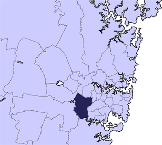
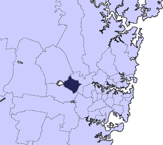
The City of Bankstown was a local government area in the south-west region of Sydney, Australia, centred on the suburb of Bankstown, from 1895 to 2016. The last mayor of the City of Bankstown Council was Clr Khal Asfour, a member of the Labor Party.

The Fairfield City Council is a local government area in the west of Sydney, in the state of New South Wales, Australia. The council was first incorporated as the "Municipal District of Smithfield and Fairfield" on 8 December 1888, and the council's name was changed to the "Municipality of Fairfield" in 1920, before being proclaimed a city in 1979. The City of Fairfield comprises an area of 102 square kilometres (39 sq mi) and as of the 2016 census had a population of 198,817. The mayor of the City of Fairfield is Cr. Frank Carbone, the first popularly-elected independent mayor of Fairfield.

The City of Ryde is a local government area in the Northern Sydney region, in the state of New South Wales, Australia. It was first established as the Municipal District of Ryde in 1870, became a municipality in 1906 and was proclaimed as the City of Ryde in 1992.

Moorebank is a suburb of Sydney, in the state of New South Wales, Australia. Moorebank is located 27 kilometres south-west of the Sydney central business district in the local government area of the City of Liverpool.
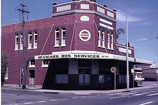
McVicar's Bus Services was an Australian bus operator that operated services in the south-west suburbs of Sydney from 1919 until 1978.
De Burghs Bridge is a road bridge that carries the Lane Cove Road, part of the A3, across the Lane Cove River in Macquarie Park, Sydney, Australia. The bridge stretches from Macquarie Park in the south to West Pymble in the north.

Henry Lawson Drive is an 20-kilometre (12 mi) urban mostly two-lane road located in Sydney, New South Wales, Australia. The road's northwestern terminus is at the Hume Highway and Woodville Road at the "Meccano Set" in Villawood, with its southeastern terminus at Forest Road and Jacques Avenue Peakhurst. The road is named in honour of Henry Lawson (1867–1922), one of Australia's foremost poets.
The Cumberland Free Press was a short-lived weekly Australian newspaper published and printed in Parramatta, New South Wales, with a coverage extending across the Inner West, Western and North West regions of Sydney. The paper was first published on 22 June 1895 and ceased publication in March 1898.
The Weekly Advance was an English-language tabloid newspaper published in Granville, New South Wales, Australia, between 1892 and 1894. The paper principally covered the townships of Granville, Auburn, and Rookwood, with circulation and content extending to Clyde. Flemington, Homebush, Strathfield, Bankstown, Mortlake, Newington, Merrylands, Guildford, Smithfield and Fairfield.

The Municipality of Lidcombe was a local government area in the Western region of Sydney, New South Wales, Australia. The municipality was proclaimed as the Borough of Rookwood on 8 December 1891 and was renamed to the Municipality of Lidcombe, a portmanteau of two mayor's names, in order to differentiate itself from the expanding necropolis, from 15 October 1913. It included the modern suburbs of Rookwood, Lidcombe, Homebush Bay, Berala and parts of Newington, Silverwater, Homebush West and Regents Park. From 1 January 1949, the council was amalgamated into the Municipality of Auburn, with the passing of the Local Government (Areas) Act 1948.

The Municipality of Granville was a local government area in the Western region of Sydney, New South Wales, Australia. The municipality was proclaimed as the Borough of Granville on 20 January 1885. It included the modern suburbs of Granville, South Granville, Camellia, Rosehill, Clyde and parts of Harris Park, Guildford and Merrylands. From 1 January 1949, the council was amalgamated into the City of Parramatta, with the passing of the Local Government (Areas) Act 1948.
The Municipality of Dundas was a local government area in the North-western region of Sydney, New South Wales, Australia. Initially proclaimed as the "Borough of Dundas" on 23 March 1889, the southern part of the municipality seceded in June 1891 as the Municipal District of Ermington and Rydalmere. From 1891, the municipality included the modern suburbs of Dundas, Dundas Valley and parts of Ermington, Epping, Eastwood, Melrose Park, Oatlands and Carlingford. From 1 January 1949, the council was amalgamated into the City of Parramatta, with the passing of the Local Government (Areas) Act 1948.

