
Port Jackson, commonly known as Sydney Harbour, consists of the waters of Sydney Harbour, Middle Harbour, North Harbour and the Lane Cove and Parramatta Rivers, is the ria or natural harbour of Sydney, New South Wales, Australia. The harbour is an inlet of the Tasman Sea. It is the location of the Sydney Opera House and Sydney Harbour Bridge. The location of the first European settlement and colony on the Australian mainland, Port Jackson has continued to play a key role in the history and development of Sydney.

Gladesville Bridge is a heritage-listed concrete arch road bridge that carries Victoria Road over the Parramatta River, linking the Sydney suburbs of Huntleys Point and Drummoyne, in the local government areas of Canada Bay and Hunter's Hill, in New South Wales, Australia. Despite its name, the bridge is not in Gladesville.
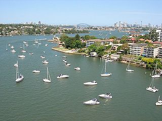
The Parramatta River is an intermediate tide-dominated, drowned valley estuary located in Sydney, New South Wales, Australia. With an average depth of 5.1 metres (17 ft), the Parramatta River is the main tributary of Sydney Harbour, a branch of Port Jackson. Secondary tributaries include the smaller Lane Cove and Duck rivers.
The Roads & Traffic Authority (RTA) was an agency of the Government of New South Wales responsible for major road infrastructure, licensing of drivers, and registration of motor vehicles. The RTA directly managed state roads and provided funding to local councils for regional and local roads. In addition, with assistance from the federal government, the RTA also managed the NSW national highway system. The agency was abolished in 2011 and replaced by Roads & Maritime Services.

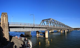
The Ryde Bridge, also called the Uhrs Point Bridge, are two road bridges that carry Concord Road, part of the A3, across Parramatta River from Ryde in the northern suburbs of Sydney to Rhodes in Sydney's inner west, in New South Wales, Australia.

Putney is a suburb of Northern Sydney, New South Wales, Australia. It is located 14 kilometres (9 mi) north-west of the Sydney central business district on the northern bank of the Parramatta River. Its local government area is the City of Ryde.
Mortlake is a suburb in the Inner West of Sydney, in the state of New South Wales, Australia. It is 10 kilometres west of the Sydney central business district, in the local government area of the City of Canada Bay.

Wisemans Ferry is a cable ferry across the Hawkesbury River in New South Wales, Australia. The ferry operates from the eponymous community of Wisemans Ferry on the south bank, to a point on the north bank downstream of the Hawkesbury River's confluence with the Macdonald River, connecting with the old Great North Road. The crossing has remained in use on its current site since 1829, making it the oldest ferry crossing still in operation in New South Wales, and possibly in Australia.

Transport in Sydney is provided by an extensive network of public transport operating modes including metro, train, bus, ferry and light rail, as well as an expansive network of roadways, cycleways and airports. According to the 2006 census, in terms of travel to work or study Sydney has the highest rate of public transport usage among the Australian capital cities of 26.3% with more than 80% of weekday trips to/from Central Sydney being made by public transport. According to the New South Wales State Plan, the state has Australia's largest public transport system. The public transport network is regulated by Transport for NSW.

The Captain Cook Bridge is a road bridge that carries Taren Point and Rocky Point Roads across the Georges River in southern Sydney, in the state of New South Wales, Australia. The precast prestressed concrete girder bridge crosses near the river mouth as it empties into Botany Bay; and links the St George and Sutherland areas of Sydney. The bridge comprises a dual carriageway with three lanes in each direction of highway grade-separated conditions; and pedestrian and bicycle traffic, via two grade-separated paths. on the eastern and western sides of the bridge.
Tom Uglys Bridge are two road bridges, completed in 1929 and 1987, that carry the Princes Highway across the Georges River in southern Sydney, in the state of New South Wales, Australia. The bridges link the St George area at Blakehurst to the Sutherland Shire at Sylvania. Tom Uglys Bridge is one of six major road crossings of Georges River.

Kalang, later Sydney Queen, was a vehicular ferry and later show boat on Sydney Harbour. A steel-hulled, steam screw ferry, she and sister Kara Kara were the largest vehicular ferries to operate in Sydney and the largest ferries operated by Sydney Ferries Limited.

The Sackville Ferry is a cable ferry across the Hawkesbury River in New South Wales, Australia. The vehicular ferry connects the communities of Sackville, on the north/west bank of the river, and Sackville North, on the south/east bank. Because of the tortuous course of the river, the ferry actually runs north-west from Sackville to Sackville North.

Webbs Creek Ferry is a cable ferry across the Hawkesbury River in New South Wales, Australia. The ferry operates from the community of Wisemans Ferry, to a point up-stream of the Hawkesbury River's confluence with the Macdonald River, thus connecting with St Albans Road that follows the west bank of the Macdonald River.

The Berowra Waters Ferry is a cable ferry across the Berowra Creek, a tributary of the Hawkesbury River, located in the Berowra Valley National Park, Sydney, Australia. The ferry operates from the community of Berowra Waters on the west bank of the creek, to a landing on the east bank, thus connecting with the road to Berowra Heights.
The Lower Portland Ferry is a cable ferry across the Hawkesbury River in New South Wales, Australia. The ferry is situated in the community of Lower Portland.
The Bluff Point Ferry, Lawrence is a cable ferry across the Clarence River in New South Wales, Australia. The ferry operates between the town of Lawrence and Woodford Island, and forms part of the route east from Lawrence to the coast. It is the busiest vehicular ferry in New South Wales.

Roads and Maritime Services was an agency of the New South Wales Government responsible for building and maintaining road infrastructure and managing the day-to-day compliance and safety for roads and waterways.
Sydney Ferries Limited operated ferry services on Sydney Harbour from 1900 until June 1951.

Sydney Harbour ferry services date back to the first years of Sydney's European settlement. Slow and sporadic boats ran along the Parramatta River from Sydney to Parramatta and served the agricultural settlements in between. By the mid-1830s, speculative ventures established regular services. From the late-nineteenth century the North Shore developed rapidly. A rail connection to Milsons Point took alighting ferry passengers up the North Shore line to Hornsby, New South Wales via North Sydney. Without a bridge connection, increasingly large fleets of steamers serviced the cross harbour routes and in the early twentieth century, Sydney Ferries Limited was the largest ferry operator in the world.


