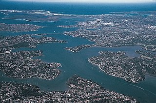
The Georges River, also known as Tucoerah River, is an intermediate tide-dominated drowned valley estuary, that is located in Sydney, Australia. The Georges River is located south and south-west from the Sydney central business district, with the mouth of the river being at Botany Bay.
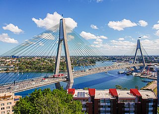
The Anzac Bridge is an eight-lane cable-stayed bridge that carries the Western Distributor (A4) across Johnstons Bay between Pyrmont and Glebe Island, on the western fringe of the Sydney central business district, New South Wales, Australia. The bridge forms part of the road network leading from the central business district, the Sydney Harbour Bridge, and Cross City Tunnel to the Inner West and Northern Suburbs.

Glebe is an inner-western suburb of Sydney in New South Wales. Glebe is located 3 kilometres (1.9 mi) southwest of the Sydney central business district in the Inner West region.
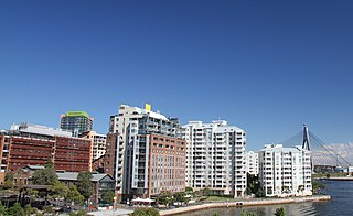
Pyrmont is an inner-city suburb of Sydney, in the state of New South Wales, Australia 2 kilometres south-west of the Sydney central business district in the local government area of the City of Sydney. It is also part of the Darling Harbour region. As of 2011, it is Australia's most densely populated suburb.

Glebe Point Road is the main road of the inner city suburb of Glebe in Sydney, New South Wales, Australia. It is a boutique shopping strip with numerous restaurants and cafés.

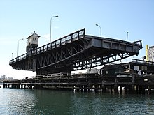
The Glebe Island Bridge is a heritage-listed disused swing Allan truss road bridge that carried Victoria Road across Johnstons Bay, located in the inner city Sydney suburb of Pyrmont in the City of Sydney local government area of New South Wales, Australia. The bridge, that connected Rozelle to Pyrmont by road, is one of the last remaining swing bridges of its type in Australia and in the world. It was designed by Percy Allan and built from 1899 to 1903 by Bridges Branch of NSW Public Works Department. It is also known as RMS Bridge No. 61. It was added to the New South Wales State Heritage Register on 29 November 2013 and was listed on the Register of the National Estate on 19 April 1989.

The Lapstone Zig Zag was a zig zag railway built between Emu Plains and Blaxland stations on the Main Western Line of New South Wales in Australia. Constructed between 1863 and 1865 to overcome an otherwise insurmountable climb up the eastern side of the Blue Mountains, the zig zag and associated Knapsack Viaduct, a sandstone arch viaduct, were designed by John Whitton, Engineer-in-Charge of New South Wales Government Railways, and were built by William Watkins. The zig zag was listed on the Blue Mountains local government heritage register on 27 December 1991; while the adjacent Knapsack Viaduct was listed on the New South Wales Heritage Database on 2 April 1999. The Lapstone Zig Zag was the world-first Zig Zag constructed on any main-line railway.

White Bay is a bay on Sydney Harbour with a surrounding locality near the suburbs of Balmain and Rozelle in the Inner West of Sydney, New South Wales, Australia.

The Woronora River is a perennial river of the Sydney Basin, located in the Sutherland Shire local government area of Greater Metropolitan Sydney, approximately 22 kilometres (14 mi) south of the Sydney central business district, in New South Wales, Australia.

Wentworth Park is a park near the suburbs of Glebe and Ultimo in Sydney, New South Wales, Australia.

Western Distributor is a 4.3-kilometre-long (2.7 mi) grade-separated motorway that is primarily elevated for the majority of its route on the western fringe of the Sydney central business district. It links the southern end of Bradfield Highway at the Sydney Harbour Bridge to Victoria Road in Rozelle, at its western terminus near White Bay. It is a constituent part of the A4 route.
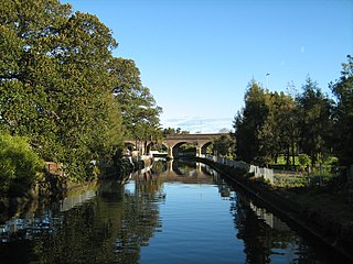
Johnstons Creek, formerly Johnston's Creek, is an urban gully, located in Sydney, Australia and situated in the Inner West and Sydney local government areas. The creek flows from Petersham, past Annandale, Camperdown, Forest Lodge and Harold Park, before spilling into Rozelle Bay, within Sydney Harbour.

Victoria Road is a major road in Sydney, New South Wales, Australia, connecting Parramatta with Rozelle and is currently one of the longest roads in Sydney. The road passes over two major bridges: the Iron Cove Bridge over Iron Cove, and the Gladesville Bridge over the Parramatta River.

This list documents historical bridges located in New South Wales, Australia. Road, rail and pedestrian bridges are listed. Generally bridges built before World War II (1939) have been included in this list.

Blackwattle Bay is a bay located to the south–east of Glebe Island and east of Rozelle Bay on Sydney Harbour, in New South Wales, Australia. The bay was named in 1788 after the black wattle tree found at the bay, which was used for housing construction.

The Fred Hollows Reserve is a local government–administered reserve that is located in the eastern suburbs of Sydney, in the state of New South Wales, Australia.
George Allen Mansfield was a prominent Australian architect of the nineteenth century who designed many iconic buildings in Sydney, New South Wales, Australia.

The Old Como railway bridge is a heritage-listed former railway bridge and now footbridge and water main carrier over the Georges River between Como and Oatley in the Sutherland Shire Council and Georges River Council local government areas of New South Wales, Australia. It was designed by John Whitton and Dept of Railways and built from 1883 to 1885 by C. and E. Millar. The property is owned by Sydney Water, an agency of the Government of New South Wales. It was added to the New South Wales State Heritage Register on 15 November 2002.

The Glebe and Wentworth Park railway viaducts are a series of two heritage-listed railway bridges and arch viaducts that carry the Inner West Light Rail across Wentworth Park, Jubilee Park, and Johnstons Creek in the inner western Sydney suburb of Glebe in the City of Sydney local government area of New South Wales, Australia. They were designed by the New South Wales Government Railways and built from 1892 to 1922 by day labour. They are also known as Wentworth Park Viaduct, Jubilee Park Viaduct and Glebe Viaducts. The viaducts were added to the New South Wales State Heritage Register on 2 April 1999.

The Rozelle–Darling Harbour Goods Line is a former heavy rail goods line in Sydney, Australia, now forming the bulk of the Inner West Light Rail. It was part of the city's goods railway network; through conversion to light rail, most of the former goods line was subsumed by the Sydney Light Rail network. A section of the line became a pedestrian pathway in inner Sydney.


