Roseville Bridge

Last updated

Roseville Bridge
Rosevillebridge.jpg
Early evening traffic on Roseville Bridge, looking south-west
Coordinates 33°46′23″S151°12′13″E / 33.77310°S 151.20366°E / -33.77310; 151.20366
Carries Warringah Road AUS Alphanumeric Route A38.svg
Crosses Middle Harbour
Locale Roseville, Sydney, New South Wales, Australia
Begins Roseville (south)
Ends Frenchs Forest (north)
Maintained by Transport for NSW
Followed by Spit Bridge
Characteristics
Design Box girder
Material Pre-stressed concrete
Total length377 metres (1,237 ft)
Clearance above 17.4 metres (57 ft)
No. of lanes 6: 3 northbound; 3 southbound
History
Construction costA$1.64 million
Opened2 April 1966 (1966-04-02) by Robert Askin, NSW Premier
ReplacesOld Roseville Bridge (1924–1974)
Statistics
Daily traffic 65,000 (2016)
Location
Roseville Bridge
References
[1] [2] [3] [4]

The Roseville Bridge, is a pre-stressed concrete box girder road bridge that carries Warringah Road, part of the A38 across Middle Harbour, located adjacent to the suburb of Roseville, in Sydney, New South Wales, Australia. The bridge is one of two crossings of Middle Harbour, the other being the Spit Bridge.

Contents

Current bridge

The suburbs east of Middle Harbour grew rapidly in the years following the opening of the inaugural Roseville Bridge. On 2 April 1966, the Liberal Premier Robin Askin, the local Member for Collaroy, officially opened the new six-lane, high-level bridge, in a ceremony attended by several hundred people, including Pat Morton (Minister for Local Government and Highways), Milton Morris (Minister for Transport), Dick Healey (Member for Wakehurst), Harry Jago (Member for Gordon), and J. A. L. Shaw (Commissioner for Main Roads). [2] [5] [6] [7]

Built at a cost of A$1.64 million, the bridge was designed by the Department of Main Roads, with architects Fowell, Mansfield & Maclurcan being design consultants on the project; the primary contractor was John Holland (Constructions) Pty Ltd. [8] The bridge is 377 metres (1,237 ft) long has a clearance of 17.4 metres (57 ft) from the water below. [1] However, the adjacent Pipe Bridge has a clearance of only 11 metres (36 ft). This limitation, combined with only 1.5 metres (4 ft 11 in) depth of water, make it out of reach for most cruising vessels. Along with the bridge, a significant upgrade of the approach roads was completed, which became the six-lane Warringah Road. This upgraded section of road is approximately 2 kilometres (1.2 mi) long.

Today Roseville Bridge is part of a major thoroughfare from the Pacific Highway at Roseville to the Northern Beaches and suburbs east of Middle Harbour. Due to the halt of the construction of the Warringah Expressway across Middle Harbour to Wakehurst Parkway and the Burnt Bridge Creek Deviation, which is the only part of the Warringah Expressway built on the Northern Beaches by the Labor Wran government, there are today only two other major roads to these areas: Mona Vale Road, and Spit Road which crosses Middle Harbour downstream from Roseville Bridge using the Spit Bridge.

The road carries three lanes of traffic towards Roseville, and three lanes of traffic towards Frenchs Forest. A grade-separated shared pedestrian footpath and cycleway is located on the western side of the bridge.

On 8 March 2022, torrential rain and inadequate drainage led to the bridge being dubbed the new "Roseville Aqueduct" with images showing floating cars and water fall edge. [9]

Former Roseville Bridge, 1924–1974

Old Roseville Bridge
Coordinates 33°46′27″S151°12′19″E / 33.774266°S 151.205181°E / -33.774266; 151.205181
Carries
  • Babbage Road
  • Warringah Road
CrossesMiddle Harbour
LocaleRoseville, Sydney, New South Wales, Australia
Followed byRoseville Bridge
Characteristics
DesignLow-level bridge
MaterialConcrete
Total length240 feet (73 m)
Longest span40 feet (12 m)
No. of spans6
Piers in water5
No. of lanes 2
History
DesignerR. S. Morris
Constructed byJohn Howie and Sons
Construction cost 8548
Opened20 September 1924 (1924-09-20)
Collapsed1974
Closed1966
ReplacesFerry
Replaced byRoseville Bridge (since 1966)
References
[10] [2] :82

An original bridge across Middle Harbour at Roseville was built jointly by the Willoughby, Ku-ring-gai and Warringah councils; with fifty percent of the funding provided by the NSW Government. It was built of reinforced concrete by unemployed returned servicemen and opened on 20 September 1924. It was claimed to be the longest bridge of that type in NSW although the bridge across the Hawkesbury River at North Richmond was longer. It was claimed to be the first bridge supported on reinforced concrete piles. [2] This low-level two-lane bridge was located downstream of the current bridge, and connected Babbage Road to what is today called Healey Way, which is the entrance to Davidson Park within Garigal National Park. [1] [11] The first bridge replaced an earlier ferry service consisting of rowing boats across the narrowest section of water. [12]

The 1924 bridge survived the opening of the new bridge, and provided pedestrian access only, until it was demolished in 1974, [12] along with Roseville Baths. Almost nothing remains from these structures.

See also

Related Research Articles

<span class="mw-page-title-main">Sydney Harbour Bridge</span> Bridge across Sydney Harbour in Australia

The Sydney Harbour Bridge is a steel through arch bridge in Sydney, spanning Sydney Harbour from the central business district (CBD) to the North Shore. The view of the bridge, the harbour, and the nearby Sydney Opera House is widely regarded as an iconic image of Sydney, and of Australia itself. Nicknamed "The Coathanger" because of its arch-based design, the bridge carries rail, vehicular, bicycle and pedestrian traffic.

<span class="mw-page-title-main">North Shore (Sydney)</span> Region in New South Wales, Australia

The North Shore is a region within Northern Sydney, in the state of New South Wales, Australia, generally referring to suburbs located on the northern side of Sydney Harbour up to Wahroonga, and suburbs between Middle Harbour and the Lane Cove River.

<span class="mw-page-title-main">Northern Beaches</span> Region in New South Wales, Australia

The Northern Beaches is a region within Northern Sydney, in the state of New South Wales, Australia, near the Pacific coast. This area extends south to the entrance of Port Jackson, west to Middle Harbour and north to the entrance of Broken Bay. The area was formerly inhabited by the Garigal or Caregal people in a region known as Guringai country.

<span class="mw-page-title-main">Frenchs Forest, New South Wales</span> Suburb of Sydney, New South Wales, Australia

Frenchs Forest is a suburb of northern Sydney, in the state of New South Wales, Australia. Frenchs Forest is 13 kilometres north of the Sydney central business district in the local government area of Northern Beaches Council. Frenchs Forest is part of Sydney's Northern Beaches region and also considered to be part of the Forest District, colloquially known as The Forest by its locals.

<span class="mw-page-title-main">Wynyard railway station, Sydney</span> Heritage-listed railway station in Sydney, New South Wales, Australia

Wynyard railway station is a heritage-listed underground commuter rail station located in the north-west precinct of the Sydney central business district, in New South Wales, Australia. The station opened on 28 February 1932 to coincide with the opening of the Sydney Harbour Bridge.

<span class="mw-page-title-main">Roads & Traffic Authority</span>

The Roads & Traffic Authority (RTA) was an agency of the Government of New South Wales responsible for major road infrastructure, licensing of drivers, and registration of motor vehicles. The RTA directly managed state roads and provided funding to local councils for regional and local roads. In addition, with assistance from the federal government, the RTA also managed the NSW national highway system. The agency was abolished in 2011 and replaced by Roads & Maritime Services.

<span class="mw-page-title-main">Pyrmont Bridge</span> Heritage-listed bridge across Cockle Bay in Sydney, Australia

The Pyrmont Bridge, a heritage-listed swing bridge across Cockle Bay, is located in Darling Harbour, part of Port Jackson, west of the central business district in the City of Sydney local government area of New South Wales, Australia. Opened in 1902, the bridge initially carried motor vehicle traffic via the Pyrmont Bridge Road between the central business district and Pyrmont. Since 1981 the bridge has carried pedestrian and bicycle traffic only, as motor vehicles were diverted to adjacent freeway overpasses. The bridge was added to the New South Wales State Heritage Register on 28 June 2002, the centenary of its opening.

Killarney Heights is a suburb of Northern Sydney, situated on Middle Harbour, in the state of New South Wales, Australia. Killarney Heights is 12 kilometres north-east of the Sydney central business district in the local government area of Northern Beaches Council. Killarney Heights is part of the Forest District, colloquially known as The Forest.

<span class="mw-page-title-main">Bradfield Highway (Sydney)</span> Highway in Sydney, Australia

Bradfield Highway is a 2.1-kilometre (1.3 mi) highway that crosses the Sydney Harbour Bridge in Sydney, New South Wales and is one of the shortest highways in Australia. It opened along with the bridge itself on 19 March 1932 and was named in honour of John Bradfield, the engineer who designed and helped construct it.

<span class="mw-page-title-main">Warringah Freeway</span> Freeway in Sydney, Australia

Warringah Freeway is a 3.5-kilometre (2.2 mi) divided freeway in Sydney, New South Wales that is part of the Sydney Orbital Network. The primary function of the freeway is to provide an alternative high-grade route from the Sydney Harbour Tunnel and Bradfield Highway at Milsons Point to the A8 and Gore Hill Freeway. The freeway reduces traffic demands on Pacific Highway throughout Sydney's Lower North Shore, bypassing North Sydney and Crows Nest, and provides a vital link to access most of the suburbs in Sydney and is also a major route to the north, south, east and west of the central business district.

<span class="mw-page-title-main">Iron Cove Bridge</span> Bridge in New South Wales, Australia

The Iron Cove Bridge is a heritage-listed road bridge that carries Victoria Road (A40) across Iron Cove, linking the Sydney suburbs of Drummoyne to Rozelle in the City of Canada Bay local government area of New South Wales, Australia.

<span class="mw-page-title-main">Fig Tree Bridge</span> Bridge in New South Wales, Australia

The Fig Tree Bridge is a road bridge that carries Burns Bay Road across the Lane Cove River, and connects the suburbs of Hunters Hill in the south and Linley Point in the north, located approximately seven kilometres northwest of the central business district of Sydney in New South Wales, Australia. The concrete girder bridge carries motor vehicles, and a grade-separated footpath and cycleway.

<span class="mw-page-title-main">Cahill Expressway</span> Highway in Sydney, Australia

Cahill Expressway is an urban freeway in Sydney and was the first freeway constructed in Australia, first opening to traffic in 1958. It links the southern foot of the Sydney Harbour Bridge, over an elevated roadway and through a series of sunken cuttings and tunnels between the Royal Botanic Garden and The Domain, to Woolloomooloo in Sydney's inner-eastern suburbs.

<span class="mw-page-title-main">Tom Uglys Bridge</span> Australian road bridge

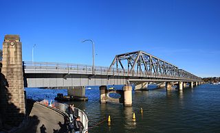
Tom Uglys Bridge are two road bridges, completed in 1929 and 1987, that carry the Princes Highway across the Georges River in southern Sydney, in the state of New South Wales, Australia. The bridges link the St George area at Blakehurst to the Sutherland Shire at Sylvania. Tom Uglys Bridge is one of six major road crossings of Georges River.

Burnt Bridge Creek Deviation is a 1.7-kilometre-long (1.1 mi) major arterial road in the Northern Beaches area of Sydney, Australia, and is a constituent part of the A8 route. It takes its name from Burnt Bridge Creek which flows beneath the road, although there is no sign of the "burnt bridge" which gives the creek its name.

<span class="mw-page-title-main">Spit Bridge</span> Bridge across the Middle Harbour in Sydney, Australia

The Spit Bridge, a steel and concrete girder bridge with a bascule lift span across the Middle Harbour, is located 10 kilometres (6.2 mi) north-east of the central business district in Sydney, Australia. The bridge carries The Spit Road (A8) from a point called The Spit, and connects the suburbs of Mosman, on the south bank and Seaforth, on the north bank.

<span class="mw-page-title-main">A8 (Sydney)</span> Road in New South Wales, Australia

The A8 is a route designation of a major metropolitan arterial route through suburban north-eastern Sydney. This name covers a few consecutive roads and is widely known to most drivers, but the entire allocation is also known – and signposted – by the names of its constituent parts: Pittwater Road, Condamine Street, Burnt Bridge Creek Deviation, Manly Road, Spit Road and Military Road.
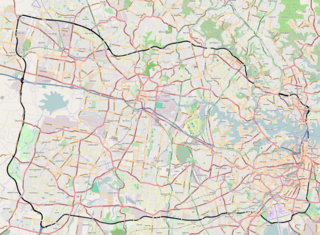
<span class="mw-page-title-main">Peats Ferry Bridge</span> Bridge in New South Wales, Australia

The Peats Ferry Bridge is a steel truss bridge that carries the Pacific Highway (B83) across the Hawkesbury River, between Kangaroo Point and Mooney Mooney Point, located 40 kilometres (25 mi) north of Sydney in New South Wales, Australia. The bridge carries the Hornsby to Kariong section of highway, while the adjacent Brooklyn Bridge carries the Pacific Motorway (M1).

<span class="mw-page-title-main">A38 (Sydney)</span>

The A38 is a route designation of a major metropolitan arterial route through suburban Sydney, linking M2 Hills Motorway in North Ryde and Pittwater Road (A8) in Dee Why. This name covers a few consecutive roads and is widely known to most drivers, but the entire allocation is also known – and signposted – by the names of its constituent parts: Delhi Road, Millwood Avenue, Fullers Road, Pacific Highway, Boundary Street, Babbage Road and Warringah Road.

The Western Harbour Tunnel & Beaches Link is a planned underground motorway scheme in Sydney, New South Wales. It consists of a series of motorway tunnels running north-south between Burnt Bridge Creek Deviation (A8) at Balgowlah and the WestConnex at Rozelle Interchange, providing direct access from the Northern Beaches to the Inner West at Rozelle The six-lane motorway is planned to be approximately 18 km long and to be built with both State and Federal funding.

References

  1. 1 2 3 Morcombe, John (20 April 2014). "Roseville Bridge the first to link the peninsula with the rest of Sydney". Manly Daily . Retrieved 12 January 2015.
  2. 1 2 3 4 Kass, Terry (February 2006). "RTA Thematic History: A component of the RTA Heritage and Conservation Register" (PDF). NSW Roads & Maritime Services (PDF) (2nd ed.). Government of New South Wales. pp. 24, 90. Retrieved 12 January 2015.
  3. "Average Daily Traffic Volumes" (PDF). NSW Roads & Maritime Services (PDF). Government of New South Wales. 2012. Retrieved 12 January 2015.
  4. "Roseville Bridge stands the test of time, celebrating 50 years". North Shore Times. 11 April 2016. Retrieved 16 April 2020.
  5. "Opening of new Roseville Bridge" (Photograph). Northern Beaches Council. 2 April 1966. Retrieved 7 September 2023.
  6. "Opening of new Roseville Bridge" (Photograph). Northern Beaches Council. 2 April 1966. Retrieved 7 September 2023.
  7. "Bridge opened". The Sun-Herald. 3 April 1966. p. 21. One of Sydney's worst traffic bottlenecks was eliminated yesterday with the opening of the new Roseville bridge over Middle Harbour. The $1,640,000 six-lane bridge was officially opened by the Premier, Mr R. W. Askin. It spans Middle Harbour 68 feet above the water and replaces the 42-year-old, two-lane low-level bridge. Several hundred residents of Roseville and Warringah Shire went to the opening ceremony. Mr Askin cut the ribbon, after which the official party moved across in a motorcade. The barriers were then withdrawn and swarms of young children raced to be first to the other side. Mr Askin said the opening of the new bridge was "a tremendous step forward." "Compared to 42 years ago when 4,000 vehicles created a new record by crossing the old bridge in a day, 23,480 vehicles now cross Middle Harbour each day," he said.
  8. Johnson, Bob (6 March 1966). "Easter 'egg' for motorists -- another bridge". The Sun Herald. p. 57.
  9. "Roseville Aqueduct". Twitter. Retrieved 8 March 2022.
  10. "Beneath Roseville Bridge". Living Local Guide. Retrieved 5 November 2016.
  11. Bridges - land and water. NSW National Parks & Wildlife Service (Information display at the Davidson Park). Davidson: Government of New South Wales.
  12. 1 2 "The old Roseville Bridge". Powerhouse Museum. 12 May 2014. Retrieved 6 October 2020.