
The Georges River, also known as Tucoerah River, is an intermediate tide-dominated drowned valley estuary, located to the south and west of Sydney, New South Wales, Australia.

Port Jackson, consisting of the waters of Sydney Harbour, Middle Harbour, North Harbour and the Lane Cove and Parramatta Rivers, is the ria or natural harbour of Sydney, New South Wales, Australia. The harbour is an inlet of the Tasman Sea. It is the location of the Sydney Opera House and Sydney Harbour Bridge. The location of the first European settlement and colony on the Australian mainland, Port Jackson has continued to play a key role in the history and development of Sydney.

The Princes Highway is a major road in Australia, extending from Sydney to Adelaide via the coast through the states of New South Wales, Victoria and South Australia. It has a length of 1,941 kilometres (1,206 mi) or 1,898 kilometres (1,179 mi) via the former alignments of the highway, although these routes are slower and connections to the bypassed sections of the original route are poor in many cases.

The A3 is a major metropolitan arterial route in Sydney, formerly designated Metroad 3. The A3 runs from its intersection with the A8 at Mona Vale at the north end, to the southerly of its two intersections with the A1, Princes Highway, at Blakehurst. The highest speed limit on the A3 is 90 km/h (56 mph) on Mona Vale Road.
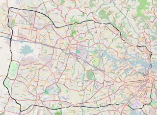
The Sydney Orbital Network is a 110 kilometre motorway standard ring road around and through Sydney, the capital of New South Wales in Australia. It runs north from Sydney Airport, underneath the CBD to the North Shore, west to the Hills District, south to Prestons and then east to connect with the airport. Much of the road is privately owned and financed by tolls.
The Roads & Traffic Authority (RTA) was an agency of the New South Wales Government responsible for major road infrastructure, licensing of drivers, and registration of motor vehicles. The RTA directly managed state roads and provided funding to local councils for regional and local roads. In addition, with assistance from the federal government, the RTA also managed the NSW national highway system. The agency was abolished in 2011 and replaced by New South Wales Roads and Maritime Services.

The Pacific Motorway is a motorway in Australia between Brisbane, Queensland, and Brunswick Heads, New South Wales, through the New South Wales–Queensland border at Tweed Heads.

Botany Bay, an open oceanic embayment, is located in Sydney, New South Wales, Australia, 13 km (8 mi) south of the Sydney central business district. Its source is the confluence of the Georges River at Taren Point and the Cooks River at Kyeemagh, which flows 10 km (6 mi) to the east before meeting its mouth at the Tasman Sea, midpoint between the suburbs of La Perouse and Kurnell. The northern headland of the entrance to the bay from the Tasman Sea is Cape Banks and, on the southern side, the outer headland is Cape Solander and the inner headland is Sutherland Point.

Kyeemagh is a suburb in southern Sydney, in the state of New South Wales, Australia. It is 12 kilometres south of the Sydney central business district, on the western shore of Botany Bay. Kyeemagh is in the local government area of the Bayside Council and is part of the St George area.

The Bradfield Highway is a highway in Sydney, New South Wales, Australia. At 2.5 kilometres (1.6 mi) long it is one of the shortest highways in Australia.

The Fig Tree Bridge is a road bridge that carries Burns Bay Road across the Lane Cove River, and connects the suburbs of Hunters Hill in the south and Linley Point in the north, located approximately seven kilometres northwest of the central business district of Sydney in New South Wales, Australia. The concrete girder bridge carries motor vehicles, and a grade-separated footpath and cycleway.

Transport in Sydney is provided by an extensive network of public transport operating modes including metro, train, bus, ferry and light rail, as well as an expansive network of roadways, cycleways and airports. According to the 2006 census, in terms of travel to work or study Sydney has the highest rate of public transport usage among the Australian capital cities of 26.3% with more than 80% of weekday trips to/from Central Sydney being made by public transport. According to the New South Wales State Plan, the state has Australia's largest public transport system. The public transport network is regulated by Transport for NSW.

The Captain Cook Bridge is a road bridge that carries Taren Point and Rocky Point Roads across the Georges River in southern Sydney, in the state of New South Wales, Australia. The precast prestressed concrete girder bridge crosses near the river mouth as it empties into Botany Bay; and links the St George and Sutherland areas of Sydney. The bridge comprises a dual carriageway with three lanes in each direction of highway grade-separated conditions; and pedestrian and bicycle traffic, via two grade-separated paths. on the eastern and western sides of the bridge.
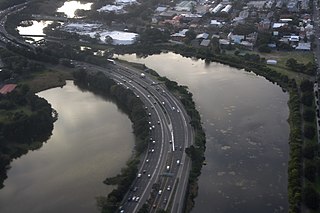
The Southern Cross Drive is a 4.8 km (3 mi) dual carriage untolled motorway in Sydney, New South Wales, Australia. Part of the M1 and Sydney Orbital Network, the road, a freeway that opened in 1969, links the Eastern Distributor and South Dowling Street at Kensington in the north to General Holmes Drive at Sydney Airport in the south.

The Nowra Bridge is a road bridge that carries the Princes Highway over the Shoalhaven River, at Nowra in the Shoalhaven Council local government area, on the South Coast of New South Wales, Australia. The bridge joins the main area of Nowra to North Nowra and Bomaderry.

General Holmes Drive is a 5-kilometre (3.1 mi) major divided road located in Sydney, New South Wales, Australia. The road forms part of the M1, the A1, the Sydney Orbital Network, and the Australian Highway 1 network. Initially built in 1919 as a two-lane road and duplicated in 1951, the road partially circumnavigates Sydney Airport with its north-eastern terminus in Mascot, heading west and then south and then south-west, with its south-western terminus with The Grand Parade in Brighton-Le-Sands.
The Camden Valley Way is a 24-kilometre (15 mi) arterial road between Sydney and the historic town of Camden.

The Botany Water Reserves are a heritage-listed former water supply system and now parkland and golf course at 1024 Botany Road, Mascot, Bayside Council, Sydney, New South Wales, Australia. It was designed by City Engineers, W. B. Rider, E. Bell (1856–1871), and Francis Bell (1871–1878). It is also known as Botany Swamps, Botany Wetlands, Mills Stream, Bridge Pond, Lakes Golf Course, Eastlakes Golf Course, Bonnie Doon Golf Course, and Astrolabe Park. The property is owned by Sydney Water, an agency of the Government of New South Wales. It was added to the New South Wales State Heritage Register on 18 November 1999.

Sewage Pumping Station 38 is a heritage-listed sewerage pumping station located on General Holmes Drive, in the Sydney suburb of Mascot, in the Bayside Council local government area of New South Wales, Australia. It was designed and built by the Metropolitan Water Sewerage and Drainage Board. It is also known as SPS 38, Mascot Sewage Pumping Station and SP0038. The pumping station is owned by Sydney Water, an agency of the Government of New South Wales. It was added to the New South Wales State Heritage Register on 18 November 1999.

