The Hume Highway, inclusive of the sections now known as the Hume Freeway and Hume Motorway, is one of Australia's major inter-city national highways, running for 840 kilometres (520 mi) between Melbourne in the southwest and Sydney in the northeast. Upgrading of the route from Sydney's outskirts to Melbourne's outskirts to dual carriageway was completed on 7 August 2013.

Federal Highway is a highway in New South Wales and the Australian Capital Territory. It is a part of a motorway-standard link between Sydney and Canberra, and is also the main thoroughfare between those cities.

The A9 is the outer western Sydney Bypass connecting Campbelltown to Windsor. It was formerly designated Metroad 9, which was one of Sydney's Metroads.

The Cumberland Highway is a 34-kilometre (21 mi) long urban highway located in Sydney, New South Wales, Australia. The highway links the Pacific Highway (A1/B83) and Pacific Motorway (M1) at Pearces Corner, Wahroonga in the northeast with the Hume Highway (A22/A28) at Liverpool in the southwest.

The Westlink M7 or M7 Motorway, formerly Western Sydney Orbital, is a tolled urban motorway in Sydney and is a part of the Sydney Orbital Network. Owned by the NorthWestern Roads (NWR) Group, it connects three motorways: M5 South-West Motorway at Prestons, M4 Western Motorway at Eastern Creek and M2 Hills Motorway at Baulkham Hills. It opened on 16 December 2005, eight months ahead of schedule.

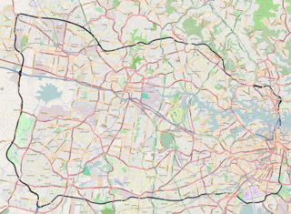
The Sydney Orbital Network is a 110 kilometre motorway standard ring road around and through Sydney, the capital of New South Wales in Australia. It runs north from Sydney Airport, underneath the CBD to the North Shore, west to the Hills District, south to Prestons and then east to connect with the airport. Much of the road is privately owned and financed by tolls.

Sir Arthur Roden Cutler, was an Australian diplomat, the longest serving Governor of New South Wales and a recipient of the Victoria Cross, the highest award for gallantry "in the face of the enemy" that can be awarded to British and Commonwealth armed forces.

The Remembrance Driveway in Australia is a road and memorial system of arboreal parks, plantations, and road-side rest areas that provide a living memorial in honour of those who served in the Australian Defence Forces in World War II, the Korean War, Malayan Emergency and the Vietnam War, and who continue to serve around the world. The most prominent feature of the driveway are a series of rest areas dedicated in honour of the Australian Victoria Cross recipients from World War II onwards.

The Roads & Traffic Authority (RTA) was an agency of the New South Wales Government responsible for major road infrastructure, licensing of drivers, and registration of motor vehicles. The RTA directly managed state roads and provided funding to local councils for regional and local roads. In addition, with assistance from the federal government, the RTA also managed the NSW national highway system. The agency was abolished in 2011 and replaced by New South Wales Roads and Maritime Services.

Prestons is a suburb of Sydney, in the state of New South Wales, Australia 37 kilometres south-west of the Sydney central business district, in the local government area of the City of Liverpool.

The Hills Motorway is a tollway in north-western Sydney, Australia, owned by toll road operator Transurban. It forms majority of Sydney's M2 route and part of the 110 km Sydney Orbital Network, with Lane Cove Tunnel constituting the rest of the M2 route. The M2 is also part of the National Highway west of Pennant Hills Road. It was known as the North West Transport Link during planning in the early 1990s.

The M5 Motorway is a 29-kilometre-long (18 mi) motorway located in Sydney, New South Wales, Australia that is designated with the M5 route and forms part of the Sydney Orbital Network. The M5 route number comprises two connected parts, separately owned and operated:
The Prospect Highway is an 11.5-kilometre (7.1 mi) secondary urban road located in the western suburbs of Sydney, New South Wales, Australia. The highway provides a free alternative link from the tolled M2 Hills and the Westlink M7 motorways in the northeast to the M4 Western Motorway in the southwest and further south.
Sydney Bypass refers to a number of roads, existing and proposed, that motorists can use to avoid the congested approaches to the Sydney central business district (CBD). The main bypasses are:
The Camden Valley Way is a 24-kilometre (15 mi) arterial road between Sydney and the historic town of Camden.
The Remembrance Drive is a rural road that links Camden and Aylmerton. The road served as the former alignment of Hume Highway from 1928 to 1984 and now forms part of the Old Hume Highway.

The Light Horse Interchange is a motorway interchange located in Eastern Creek, Sydney, Australia at the junction of the M4 and M7 motorways. The interchange is the largest in the southern hemisphere and was opened to traffic in December 2005. The interchange was named in honour of the Australian Light Horse Brigades of World War I, who trained at the Wallgrove Army camp that was located near the site of the interchange prior to deploying overseas.
The M7 cycleway is a 40-kilometre-long (25 mi) shared use path for cyclists and pedestrians that is generally aligned with the Westlink M7 in Greater Western Sydney, New South Wales, Australia. The southern terminus of the cycleway is located adjacent to the Camden Valley Way at Prestons, while the northern terminus is located adjacent to the Old Windsor Road at Glenwood. The cycleway crosses the M4 motorway at Eastern Creek.

The Horsley Drive is a 13-kilometre (8.1 mi) urban sealed road located in the City of Fairfield in greater western Sydney, New South Wales, Australia. The road's northwestern terminus is located at the entrance of Western Sydney Parklands in Horsley Park, with its southeastern terminus located at the road's junction with Hume Highway, located in Villawood.


