National Highway (Australia)

Last updated

Road sign of the National Highway. National Highway Australia.jpg
Road sign of the National Highway.
National Highway Sign located on the Stuart Highway near Darwin, listing distances to key locations on this highway. Stuart Highway Australia.jpg
National Highway Sign located on the Stuart Highway near Darwin, listing distances to key locations on this highway.
Map of the National Highway System Australia regions map.svg
Map of the National Highway System

The National Highway (part of the National Land Transport Network) is a system of roads connecting all mainland states and territories of Australia, and is the major network of highways and motorways connecting Australia's capital cities and major regional centres.

Contents

History

Legislation

National funding for roads began in the 1920s, with the federal government contributing to major roads managed by the state and territory governments. [1] :21 However, the Federal Government did not completely fund any roads until 1974, [1] :21–23 when the Whitlam government introduced the National Roads Act 1974. [2] Under the act, the states were still responsible for road construction and maintenance, but were fully compensated for money spent on approved projects. [2] :S7

In 1977, the 1974 Act was replaced by the State Grants (Roads) Act 1977, which contained similar provisions for the definition of "National Highways". [3]

In 1988, the National Highway became redefined under the Australian Land Transport Development (ALTD) Act 1988, [4] which had various amendments up to 2003. The 1988 Act was largely concerned with funding road development in cooperation with the state governments. The federal transport minister defined the components of the National Highway, and also a category of "Road of National Importance" (RONI), with federal funding implications. Section 10.5 of the Act required the state road authorities to place frequent, prominent, signs on the National Highways and RONI projects funded by the federal government. [5]

In 2005, the National Highway became the National Land Transport Network, under the AusLink (National Land Transport) Act 2005. The criteria for inclusion in the network was similar to the previous legislation, but expanded to include connections to major commercial centres, and inter-modal facilities. [6] All of the roads included in National Land Transport Network as of 2005 were formally defined by regulation in October 2005. [7] The Minister for Transport may alter the list of roads included in the network. Three amendments to the scheduled list of roads have been made, in February 2007, September 2008 and February 2009. [8] The third variation, [9] published in February 2009, is current as of September 2012.

Under AusLink a program that operated between July 2004 and 2009, the AusLink National Network had additional links, both road and rail. The Federal Government encouraged funding from state, territory and local governments and public–private partnerships to upgrade the network and requires state government funding contributions on parts of the network, especially for new links. For example, the Pacific Highway and the Calder Highway are part of the National Network, yet new projects are being funded 50/50 by federal and state governments. State contributions (generally 20%) are required on some sections of the old network near major cities.

Roads and routes

The various superseded Acts defined National Highways as roads, or a series of connected roads, that were the primary connection between two State or Territory capital cities, as well as between Brisbane and Cairns, and between Hobart and Burnie. [2] :S4 The Melbourne-Devonport ferry route is sometimes described colloquially as the 'sea highway', providing a link from Tasmania to the rest of the country by road.[ citation needed ]

The 16,000 kilometres (9,900 mi) of roads included in the original National Highway system had large variations in road quality. Some sections were no more than dirt tracks, whilst others were four lane dual carriageways. While 12,496 kilometres (7,765 mi) was sealed, there was also 3,807 kilometres (2,366 mi) worth of gravel roads. The National Highway was gradually improved, with the sealed proportion increased from 73 per cent in the early 1970s to 88 per cent by 1981. The sealing works were completed in 1989. [1] :21–23

Since 2005, National Highways were no longer defined in federal legislation. However, the routes were marked with a National Highway route marker up until 2013. These markers have "NATIONAL" printed in the upper portion of the shield, above the highway's number. The shield, text and number are coloured yellow while the background is dark green – the national colours of Australia. In 2014, the route makers retained the national colours, although the word "NATIONAL" was removed in the Australian Capital Territory, New South Wales, and parts of both Queensland and Victoria.

National Highway numbering originates from the earlier national route network. Many of the routes that are now National Highways with the signature green and gold shields, continue beyond the official National Highway as the black and white shielded national routes. Certain stretches of the National Highways have "A" and "M" tag on their shields; particularly those in Victoria and South Australia. They have completely revised their route numbering, basing it on the British M, A, B, C classifications. These states have retained the original National Highway numbering and shield decal, having added the appropriate M and A classification.

List of roads on the National Land Transport Network

Former National Highway routes

The following roads were part of the original National Highway network. Most are still signposted with National Highway route markers. In 2013, New South Wales introduced a new alphanumeric route numbering system, which no longer includes national highways.

RouteFormer routeRoad nameDestinationsDistance (km)
Canberra to Sydney:
New South Wales alphanumeric route A23.svg
A23
Australian national highway ACT 23.svg
National Highway 23
Federal Highway Canberra to ACT/NSW border73
AUS Alphanumeric Route M23.svg
M23
Australian national highway 23.svg
National Highway 23
NSW/ACT border to Yarra
AUS Alphanumeric Route M31.svg
M31
Australian national highway 31.svg
National Highway 31
Hume Highway/Hume Motorway Yarra to Sydney 187
260 kilometres
Canberra to Melbourne:
New South Wales alphanumeric route A25.svg
A25
Australian national highway ACT 25.svg
National Highway 25
Barton Highway Canberra to ACT/NSW border52
AUS Alphanumeric Route A25.svg
A25
Australian national highway 25.svg
National Highway 25
NSW/ACT border to Yass
AUS Alphanumeric Route M31.svg
M31
Australian national highway 31.svg
National Highway 31
Hume Highway Yass to Albury 294
AUS Alphanumeric Route M31.svg
M31
Australian national highway 31.svgAustralian national highway M31.svg
National Highway (M)31
Hume Freeway Wodonga to Melbourne (Thomastown)290
AUS Alphanumeric Route M80.svg
M80
Australian national highway M80.svg
National Highway M80
Western Ring Road Melbourne15
651 kilometres
Sydney to Melbourne:
AUS Alphanumeric Route M31.svg
M31
Australian national highway 31.svg
National Highway 31
Hume Motorway/Hume Highway Sydney to Albury 539
AUS Alphanumeric Route M31.svg
M31
Australian national highway 31.svgAustralian national highway M31.svg
National Highway (M)31
Hume Freeway Wodonga to Melbourne (Thomastown)290
AUS Alphanumeric Route M80.svg
M80
Australian national highway M80.svg
National Highway M80
Western Ring Road Melbourne15
844 kilometres
Sydney to Adelaide:
AUS Alphanumeric Route M31.svg
M31
Australian national highway 31.svg
National Highway 31
Hume Motorway/Hume Highway Sydney to Tarcutta 392
AUS Alphanumeric Route A20.svg
A20
Australian national highway 20.svg
National Highway 20
Sturt Highway Tarcutta to Buronga 597
AUS Alphanumeric Route A20.svg
A20
Australian national highway 20.svgAustralian national highway A20.svg
National Highway (A)20
Mildura to Hewett 370
Gawler Bypass Hewett to Willaston 3
AUS Alphanumeric Route M2.svg
M2
Australian national highway M20.svg
National Highway M20
Northern Expressway Willaston to Waterloo Corner 23
AUS Alphanumeric Route A1.svg
A1
Australian national highway 1.svgAustralian national highway A1.svg
National Highway (A)1
Port Wakefield Road Waterloo Corner to Adelaide 13
1,403 kilometres
Sydney to Brisbane:
AUS Alphanumeric Route M1.svg
M1
Australian national highway 1.svg
National Highway 1
Pacific Motorway Sydney to Newcastle 127
AUS Alphanumeric Route A43.svg
A43
Australian national highway 15.svg
National Highway 15
New England Highway Newcastle to Belford 581
AUS Alphanumeric Route A15.svg
A15
Belford to Wallangarra
Australian national highway 15.svgAustralian national highway A15.svg
National Highway (A)15
Wallangarra to Warwick 95
Cunningham Highway Warwick to Yamato127
AUS Alphanumeric Route M15.svg
M15
Australian national highway 15.svg
National Highway 15
Yamanto to Riverview
AUS Alphanumeric Route M2.svg
M2
Ipswich Motorway Riverview to Wacol 14
AUS Alphanumeric Route M7.svg
M7
Wacol to Brisbane
944 kilometres
Melbourne to Brisbane:
AUS Alphanumeric Route M80.svg
M80
Australian national highway M80.svg
National Highway M80
Western Ring Road Melbourne 15
AUS Alphanumeric Route M31.svg
M31
Australian national highway 31.svgAustralian national highway M31.svg
National Highway (M)31
Hume Freeway Melbourne (Thomastown) to Seymour 75
AUS Alphanumeric Route M39.svg
M39
Australian national highway 39.svgAustralian national highway M39.svg
National Highway (M)39
Goulburn Valley Freeway Seymour to Shepparton 59
AUS Alphanumeric Route A39.svg
A39
Australian national highway 39.svgAustralian national highway A39.svg
National Highway (A)39
Goulburn Valley Highway Shepparton to Tocumwal 110
Australian national highway 39.svg
National Highway 39
Newell Highway Tocumwal to Goondiwindi 1062
Australian national highway 39.svgAustralian national highway A39.svg
National Highway (A)39
Leichhardt Highway Goondiwindi to North Goondiwindi21
Australian national highway 85.svgAustralian national highway A39.svg
National Highway 85/A39
Gore Highway North Goondiwindi to Toowoomba 202
AUS Alphanumeric Route A2.svg
A2
Australian national highway 54.svgAustralian national highway A2.svg
National Highway 54/A2
Warrego Highway Toowoomba to Brassall 97
AUS Alphanumeric Route M2.svg
M2
Brassall to Ipswich
Australian national highway 15.svg
National Highway 15
Ipswich Motorway Ipswich to Wacol 14
AUS Alphanumeric Route M7.svg
M7
Wacol to Brisbane
1,655 kilometres
Melbourne to Adelaide:
AUS Alphanumeric Route M80.svg
M80
Australian national highway M80.svg
National Highway M80
Western Ring Road Melbourne15
AUS Alphanumeric Route M8.svg
M8
Australian national highway 8.svgAustralian national highway M8.svg
National Highway (M)8
Western Freeway Melbourne (Deer Park) to Ballarat 115
AUS Alphanumeric Route A8.svg
A8
Australian national highway 8.svgAustralian national highway A8.svg
National Highway (A)8
Western Highway Ballarat to VIC/SA border314
Dukes Highway SA/VIC border to Tailem Bend 189
AUS Alphanumeric Route A1.svg
A1
Australian national highway 1.svgAustralian national highway A1.svg
National Highway (A)1
Princes Highway Tailem Bend to Murray Bridge 25
AUS Alphanumeric Route M1.svg
M1
Australian national highway 1.svgAustralian national highway M1.svg
National Highway (M)1
South Eastern Freeway Murray Bridge to Adelaide 74
719 kilometres
Adelaide to Darwin:
AUS Alphanumeric Route A1.svg
A1
Australian national highway 1.svgAustralian national highway A1.svg
National Highway (A)1
Main North Road Adelaide to Gepps Cross tba
Port Wakefield Road Gepps Cross to Waterloo Corner tba
Port Wakefield Highway Waterloo Corner to Port Wakefield tba
Augusta Highway Port Wakefield to Port Augusta tba
AUS Alphanumeric Route A87.svg
A87
Australian national highway 87.svgAustralian national highway A87.svg
National Highway (A)87
Stuart Highway Port Augusta to SA/NT bordertba
Australian national highway 87.svg
National Highway 87
NT/SA border to Daly Waters tba
Australian national highway 1.svg
National Highway 1
Daly Waters to Darwin tba
3,035 kilometres
Perth to Adelaide:
Australian national highway 94.svg
National Highway 94
Great Eastern Highway Perth to Redcliffe tba
Great Eastern Highway Bypass Redcliffe to Hazelmere tba
Roe Highway Hazelmere to Midvale tba
Great Eastern Highway Midvale to Coolgardie tba
Coolgardie-Esperance Highway Coolgardie to Norseman tba
Australian national highway 1.svg
National Highway 1
Eyre Highway Norseman to WA/SA bordertba
AUS Alphanumeric Route A1.svg
A1
Australian national highway 1.svgAustralian national highway A1.svg
National Highway (A)1
SA/WA border to Port Augusta tba
Augusta Highway Port Augusta to Port Wakefield tba
Port Wakefield Highway Port Wakefield to Waterloo Corner tba
Port Wakefield Road Waterloo Corner to Gepps Cross tba
Main North Road Gepps Cross to Adelaide tba
2,700 kilometres
Perth to Darwin:
Australian national highway 95.svg
National Highway 95
Roe Highway Midvale (Perth) to Middle Swan (Perth)
Great Northern Highway Middle Swan (Perth) to Port Hedland
Australian national highway 1.svg
National Highway 1
Port Hedland to Wyndham
Victoria Highway Wyndham to Katherine
Stuart Highway Katherine to Darwin
Brisbane to Darwin:
AUS Alphanumeric Route M7.svg
M7
Australian national highway 15.svg
National Highway 15
Ipswich Motorway Brisbane to Wacol 14
AUS Alphanumeric Route M2.svg
M2
Wacol to Riverview
Australian national highway 54.svgAustralian national highway A2.svg
National Highway 54/A2
Warrego Highway Riverview to Brassall
AUS Alphanumeric Route A2.svg
A2
Riverview to Morven
Australian national highway 71.svgAustralian national highway A2.svg
National Highway 71/A2
Landsborough Highway Morven to Barcaldine
Australian national highway 66.svgAustralian national highway A2.svg
National Highway 66/A2
Barcaldine to Camooweal
Barkly Highway Cloncurry to Camooweal
Australian national highway 66.svg
National Highway 66
Camooweal to Tennant Creek
Australian national highway 87.svg
National Highway 87
Stuart Highway Tennant Creek to Daly Waters
Australian national highway 1.svg
National Highway 1
Daly Waters to Darwin
Brisbane to Cairns:
AUS Alphanumeric Route M1.svg
M1
Australian national highway 1.svgAustralian national highway M1.svg
National Highway (M)1
Bruce Highway Brisbane to Kybong
AUS Alphanumeric Route A1.svg
A1
Australian national highway 1.svgAustralian national highway A1.svg
National Highway (A)1
Kybong to Cairns
Hobart to Burnie:
Australian national highway 1.svg
National Highway 1
Brooker Highway Hobart to Granton
Midland Highway Granton to Launceston
Bass Highway Launceston to Burnie

History of changes to Australia's National Highway network

Australia's National Highway Network has had a number of changes since the National Roads Act 1974 was originally established in 1974. The 1974 Act empowered the Federal Minister for Transport to declare as a National Highway, any existing or proposed road in a State, which (in the Minister's opinion), was the main route between two State capitals; a State capital and Canberra; a State capital and Darwin; Brisbane and Cairns; Hobart and Burnie; or any other road which, in the Minister's opinion, was important enough to be a National Highway. [10]

Subsequent replacement legislation in 1977, 1988, and 2005, along with other intervening amendments, contained similar provisions. Notably, important roads to near-metropolitan locations such as Geelong, Bunbury and Wollongong were added in 2005, although not within the original concept of interstate National Highways.

Original routes included in 1974

The original components of the National Highway were officially declared on 20 September 1974, as "links" and terminated at the edge of each capital city. [11] The parts of the routes within the major urban areas were not defined as National Highways, [12] and the Sturt and Newell highway routes were not included in the original 1974 network. In June 1995, as a condition of federal funding, the National Highway route in New South Wales was required to remove existing tolling on the former F3 and former F6 inter-urban freeways, even though the former F6 did not become part of a National Highway until 2005. [13]

The Sydney to Adelaide route via the Hume and Sturt highways, and the Melbourne to Brisbane route via the Newell Highway, were added as links of the National Highway network in November 1992 under the 1988 Act, however the decision to use the route from Goondiwindi to Brisbane via the Gore Highway and Toowoomba, rather than the Cunningham Highway (via Warwick), was not finalized until October 1993. [14] These were the only two major routes added to the National Highway network between 1974 and 2005. In addition, the urban ends of intercity routes, and some link roads and ring roads joining national routes, were explicitly added to the National Highway network for the first time. [14]

As sections of existing highways were upgraded or replaced by nearby parallel routes of a new higher standard, the "National Highway" designation was usually moved onto the new part of the route. The principal route between Sydney and Newcastle was shifted from the old Pacific Highway onto the new Sydney-Newcastle freeway in nine separate stages between 1966 and 1999 as the freeway was progressively implemented. Similar changes were made as the Hume Highway was re-developed. [14]

Routes included in the National Land Transport Network for the first time under the 2005 legislation

Appendix 1 of the 'Auslink (National Land Transport) Bill' of 2004, listed the routes which were proposed to be included in 'The Auslink National Network'. [11] The listing included here distinguished between the components of the "former National Highway system", and the additional routes to be added to the Auslink National Network after the implementation of the new Act, which occurred in 2005. All of the existing routes of the National Highway prior to 2005 were included in the new network. The routes added with the inception of the 2005 Act (as described in Appendix 1 referenced above, some of the descriptions are somewhat ambiguous but clarified in the ensuing regulations) [15] are:

Changes to the National Land Transport Network made in 2007 [16]

Changes to the National Land Transport Network made in 2008 [17]

Changes to the National Land Transport Network made in 2009 [18]

Urban components of the national land transport (road) network

In Sydney, only a subset of the network of motorways and major roads in the Sydney metropolitan area are part of the current National Land Transport (Roads) Network, the rest are not part of the national network and therefore the Federal Government does not contribute funding on the same basis. The following roads in and around Sydney are currently part of the designated National Land Transport Network [19]

National highway route numbering

In addition to the network of federally funded National Highways defined in 1974, there was also a system of "national routes". This scheme, which predated the National Highways in 1953, was a plan to coordinate State road authorities to allocate consistent highway numbers to major highways which traversed more than one State, for the convenience of travellers. [20] The most notable example is "Highway 1", which follows the periphery of the continent, and only parts of which form part of the former National Highway and current National Land Transport (Roads) Network.

See also

Related Research Articles

<span class="mw-page-title-main">Hume Highway</span> Major national highway in Australia

Hume Highway, inclusive of the sections now known as Hume Freeway and Hume Motorway, is one of Australia's major inter-city national highways, running for 840 kilometres (520 mi) between Melbourne in the southwest and Sydney in the northeast. Upgrading of the route from Sydney's outskirts to Melbourne's outskirts to dual carriageway was completed on 7 August 2013.

<span class="mw-page-title-main">Highways in Australia</span>

Highways in Australia are generally high capacity roads managed by state and territory government agencies, though Australia's federal government contributes funding for important links between capital cities and major regional centres. Prior to European settlement, the earliest needs for trade and travel were met by narrow bush tracks, used by tribes of Indigenous Australians. The formal construction of roads began in 1788, after the founding of the colony of New South Wales, and a network of three major roads across the colony emerged by the 1820s. Similar road networks were established in the other colonies of Australia. Road construction programs in the early 19th century were generally underfunded, as they were dependent on government budgets, loans, and tolls; while there was a huge increase in road usage, due to the Australian gold rushes. Local government authorities, often known as Road Boards, were therefore established to be primarily responsible for funding and undertaking road construction and maintenance. The early 1900s saw both the increasingly widespread use of motorised transportation, and the creation of state road authorities in each state, between 1913 and 1926. These authorities managed each state's road network, with the main arterial roads controlled and maintained by the state, and other roads remaining the responsibility of local governments. The federal government became involved in road funding in the 1920s, distributing funding to the states. The depression of the 1930s slowed the funding and development of the major road network until the onset on World War II. Supply roads leading to the north of the country were considered vital, resulting in the construction of Barkly, Stuart, and Eyre Highways.

<span class="mw-page-title-main">Princes Highway</span> Highway in Australia

Princes Highway is a major road in Australia, extending from Sydney via Melbourne to Adelaide through the states of New South Wales, Victoria and South Australia. It has a length of 1,941 kilometres (1,206 mi) or 1,898 kilometres (1,179 mi) via the former alignments of the highway, although these routes are slower and connections to the bypassed sections of the original route are poor in many cases.

<span class="mw-page-title-main">Highway 1 (Australia)</span> Network of highways that circumnavigate Australia

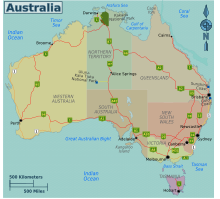
Australia's Highway 1 is a network of highways that circumnavigate the country, joining all mainland capital cities except the national capital of Canberra. At a total length of approximately 14,500 km (9,000 mi) it is the longest national highway in the world, surpassing the Trans-Siberian Highway and the Trans-Canada Highway. Over a million people traverse some part of the highway network every day.

<span class="mw-page-title-main">Pacific Highway (Australia)</span> Highway in New South Wales and Queensland

Pacific Highway is a 790-kilometre-long (491 mi) national highway and major transport route along the central east coast of Australia, with the majority of it being part of Australia's Highway 1. The highway and its adjoining Pacific Motorway between Brisbane and Brunswick Heads and Pacific Motorway between Sydney and Newcastle links the state capitals of Sydney in New South Wales with Brisbane in Queensland, approximately paralleling the Tasman Sea and the Coral Sea of the South Pacific Ocean coast, via regional cities and towns like Gosford, Newcastle, Taree, Port Macquarie, Kempsey, Coffs Harbour, Grafton, Ballina, Byron Bay, Tweed Heads and the Gold Coast, which is part of Queensland. Additionally, between Brunswick Heads and Port Macquarie, the road is also signed as Pacific Motorway, but has not been legally gazetted as such.

<span class="mw-page-title-main">Sturt Highway</span> Australian national highway

Sturt Highway is an Australian national highway in New South Wales, Victoria, and South Australia. It is an important road link for the transport of passengers and freight between Sydney and Adelaide and the regions along the route.

<span class="mw-page-title-main">Sydney Orbital Network</span> Road in New South Wales, Australia

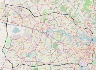
The Sydney Orbital Network is a 110 kilometre motorway standard ring road around and through Sydney, the capital of New South Wales in Australia. It runs north from Sydney Airport, underneath the CBD to the North Shore, west to the Hills District, south to Prestons and then east to connect with the airport. Much of the road is privately owned and financed by tolls.

<span class="mw-page-title-main">Roads in Victoria</span>

Victoria has the highest density of roads of any state in Australia. Unlike Australia's other mainland states where vast areas are very sparsely inhabited, Victoria has population centres spread out over most of the state, with only the far north-west and the Victorian Alps without permanent settlement. Population centres are linked by high quality highways and freeways. The state capital, Melbourne, has the most extensive freeway network of any city in Australia.

<span class="mw-page-title-main">Sydney Road</span> Road in Melbourne, Australia

Sydney Road is a major urban arterial in the northern suburbs of Melbourne, Victoria, Australia.

South Eastern Freeway is a 73 km (45 mi) freeway in South Australia (SA). It is a part of the National Highway network linking the state capital cities of Adelaide, SA, and Melbourne, Victoria. It is signed as the M1. It carries traffic over the Adelaide Hills between Adelaide and the River Murray, near Murray Bridge, where it is connected via the Swanport Bridge to the Dukes Highway, which is the main road route to Victoria.

<span class="mw-page-title-main">Princes Motorway</span> Motorway in New South Wales, Australia

The Princes Motorway is a 62-kilometre (39 mi) predominantly dual carriage untolled motorway that links Sydney to Wollongong and further south through the Illawarra region to Albion Park Rail. Part of the Australian Highway 1 network, the motorway is designated with the route number M1.

<span class="mw-page-title-main">Roads & Traffic Authority</span>

The Roads & Traffic Authority (RTA) was an agency of the Government of New South Wales responsible for major road infrastructure, licensing of drivers, and registration of motor vehicles. The RTA directly managed state roads and provided funding to local councils for regional and local roads. In addition, with assistance from the federal government, the RTA also managed the NSW national highway system. The agency was abolished in 2011 and replaced by Roads & Maritime Services.

<span class="mw-page-title-main">Goulburn Valley Highway</span>

Goulburn Valley Highway is a highway located in Victoria, Australia. The section north of the Hume Freeway is part of the Melbourne to Brisbane National Highway and is the main link between these two cities as well as a major link between Victoria and inland New South Wales. It is also the most direct route between Melbourne and the major regional centre of Shepparton in Victoria.

<span class="mw-page-title-main">Controlled-access highway</span> Highway with regulated traffic flow

A controlled-access highway is a type of highway that has been designed for high-speed vehicular traffic, with all traffic flow—ingress and egress—regulated. Common English terms are freeway, motorway and expressway. Other similar terms include throughway and parkway. Some of these may be limited-access highways, although this term can also refer to a class of highways with somewhat less isolation from other traffic.

<span class="mw-page-title-main">Pacific Motorway (Sydney–Newcastle)</span> Motorway in New South Wales, Australia

The Pacific Motorway is a 127-kilometre motorway linking Sydney to Newcastle via the Central Coast and Hunter regions of New South Wales. Formerly known but still commonly referred to by both the public and the government as the F3 Freeway, Sydney–Newcastle Freeway, and Sydney–Newcastle Expressway, it is part of the AusLink road corridor between Sydney and Brisbane. The name "F3 Freeway" reflects its former route allocation before it was decommissioned and replaced by the rollout of alphanumeric signposts.

AusLink is a former Government of Australia land transport funding program, that operated between June 2004 and 2009. The former program was administered by the former Department of Transport and Regional Services. In 2009, the program was replaced with the Nation Building Program under the Nation Building Program Act 2009. The Nation Building Program was administered by the Department of Infrastructure and Transport and that program was replaced by The National Land Transport Network, as determined by the Minister for Infrastructure and Regional Development under the National Land Transport Act 2014.

<span class="mw-page-title-main">M5 Motorway (Sydney)</span> Motorway in Sydney, Australia

The M5 Motorway is a 29-kilometre (18 mi) motorway located in Sydney, New South Wales that is part of the Sydney Orbital Network.

<span class="mw-page-title-main">M80 Ring Road</span> Freeway in Melbourne, Australia

The M80 Ring Road is a currently incomplete urban freeway ring road around Melbourne, Australia. This article will deal with the entire length of the corridor for sake of completion, as well to avoid confusion between declarations.

<span class="mw-page-title-main">Highway 1 (New South Wales)</span> Road route in New South Wales, Australia

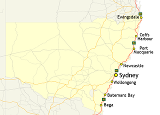
In New South Wales, Highway 1 is a 1,351-kilometre (839 mi) long route that crosses the state, from the Queensland/New South Wales border near Tweed Heads to the Victorian border near Timbillica. It provides the main coastal route between Brisbane and Melbourne via Sydney. Highway 1 continues around the rest of Australia, joining all mainland state capitals, and connecting major centres in Tasmania.

References

  1. 1 2 3 Australian National Audit Office (8 February 2001). Management of the National Highways System Program (PDF). Canberra ACT: Commonwealth of Australia. ISBN   0642442509. Archived from the original (PDF) on 12 February 2014. Retrieved 28 March 2013.
  2. 1 2 3 National Roads Act 1974 (Cth).
  3. State Grants (Roads) Act 1977 (Cth).
  4. "'Australian Land Transport Development (ALTD) Act 1988'".
  5. "'Australian Land Transport Development (ALTD) Act 1988 Section 10.5'".
  6. "AusLink (National Land Transport) Act 2005". 8 July 2005. Retrieved 29 March 2013.
  7. "'AusLink (National Land Transport) Act National Land Transport Network Determination 2005 (No. 1)'". 10 October 2005. Retrieved 23 September 2012.
  8. "Displayed here are links to compilations of the Principal, the most current at the top of the list".
  9. "'AusLink (National Land Transport) Act National Land Transport Network Determination 2005 (No. 1) as amended'" . Retrieved 23 September 2012.
  10. National Roads Act 1974 (Cth) s 4.
  11. "The National System" . Retrieved 23 September 2012.
  12. "NSW Hansard" . Retrieved 23 September 2012.
  13. 1 2 3 "The National Highway System" . Retrieved 23 September 2012.
  14. 1 2 "' AusLink (National Land Transport) Act National Land Transport Network Determination 2005 (No. 1) – F2005L03285 '". 10 October 2005. Retrieved 23 September 2012.
  15. 1 2 3 "'AusLink (National Land Transport) Act National Land Transport Network Variation 2007 (No. 1)'date=2007-02-14" . Retrieved 23 September 2012.
  16. "'AusLink (National Land Transport) Act National Land Transport Network Determination 2005 (No.1) Variation 2'". 23 September 2008. Retrieved 23 September 2012.
  17. 1 2 "'AusLink (National Land Transport) Act National Land Transport Network Determination (No. 1) 2005 Variation 3 '". 10 February 2009. Retrieved 23 September 2012.
  18. 1 2 3 4 5 6 7 8 "Schedule 1 Existing and Proposed Roads Forming Part of the National Land Transport Network".
  19. "National Routes".