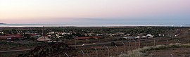
Karratha is a city in the Pilbara region of Western Australia, adjoining the port of Dampier. It is located in the traditional lands and waters of the Ngarluma people, for whom it has been Ngurra (home/Country) for tens of thousands of years. It was established in 1968 to accommodate the processing and exportation workforce of the Hamersley Iron mining company and, in the 1980s, the petroleum and liquefied natural gas operations of the Woodside-operated North West Shelf Venture located on Murujuga. As of the 2021 census, Karratha had an urban population of 17,013.[1] The city's name comes from the cattle station of the same name, which derives from a word in a local Aboriginal language meaning "good country" or "soft earth".[2] More recently, Ngarluma people have indicated the name may actually relate to an early interpretation of "Gardarra", stemming from the sacred site for the whale, located in the Karratha area, called "Gardarrabuga". The city is the seat of government of the City of Karratha, a local government area covering the surrounding region.
The land on which Karratha was established has been NgarlumaNgurra (Country) for millennia. In traditional culture, the creation of the landscape occurred in a time called Ngurra Nyujunggamu, meaning "when the world was soft".
Francis Thomas Gregory led an expedition to the North West of Western Australia in 1861. Returning to Perth, he reported the area was suitable for agricultural purposes and a possible pearling industry.[3] This was the major starting point for dispossession of Aboriginal lands across the Karratha area, as pastoralists flocked to the area to establish sheep stations.
During this period of dispossession of Aboriginal people in the Pilbara, the Karratha area became a sheep station. Many Aboriginal people were forced into unpaid labour on the sheep stations, including Karratha Station. By 1946, after Aboriginal people had worked for rations (considered a form of slavery), the Aboriginal community demanded fair waged. Labour costs increased for the Karratha Station following the 1946 Pilbara strike, who were seeking fair pay and conditions after generations of Aboriginal people working on stations for very little or no pay and in poor conditions. Many Aboriginal people ‘walked off’ Pilbara stations at this time.[4]
Archaeological dating suggests that Aboriginal people have inhabited the Pilbara region for the past 40,000 years.[5] The traditional land tenure system of Aboriginal communities, including the Ngarluma people across the Karratha area, stands in contrast to the European notion of land ownership. Instead of individuals possessing exclusive rights to utilise and sell parcels of land, Ngarluma lands were collectively owned by social groups. While certain family groups might inherit rights and responsibilities concerning particular territories, ownership primarily rested on their custodianship of the spiritual significance of the land. This encompassed spiritual sites, stories, songs, ceremonies, and sacred objects. Successive generations were entrusted with the duty of safeguarding these sacred sites, caring for the land, and perpetuating spiritual traditions and practices, with a firm prohibition against land disposal or desecration. This systems remain active today across the Karratha area, though it has been significantly disrupted due to colonisation and dispossession.[6]
The Karratha town is within the Ngarluma Native Title determination area. Native Title determination was made by the Federal Court on 2 May 2005 in Daniel v Western Australia [2005] FCA 536[7]
More recently, Ngarluma people have indicated the name may actually relate to an early interpretation of "Gardarra", stemming from the sacred site for the whale, located in the Karratha area, called "Gardarrabuga".
Geography
Karratha, an isolated city, is located approximately 1,535 kilometres (954mi) north of Perth and 241 kilometres (150mi) west of Port Hedland on the North West Coastal Highway.
It is at the south central end of Nickol Bay, which has had settlements on the bay since the 1860s.[8][9]
The city is roughly rectangular in layout and is located on flat land adjacent to Nickol Bay. Tidal salt flats and areas of mangrove separate the city from the sea. Immediately to the south of the city lies a line of low hills.
Climate
Karratha has a hot semi-arid climate (BSh), that just avoids a hot desert climate (BWh) classification. Temperatures are warm to hot all year round, with low rainfall, most of which falls in late summer due to the influence of tropical cyclones and the monsoon, although there is a second rainfall peak in early winter as the northern edges of cold fronts occasionally cause rain in the region. It is very rare for any rain to fall in the period from August to December. Winter temperatures rarely drop below 10°C, while maximums stay in the mid to high 20s and days are sunny with low humidity. Summers are very hot and usually dry although the erratic influence of the monsoon can cause periods of high humidity and thunderstorms. The record high temperature is 48.4°C (119.1°F), which was set 13 January 2022,[10] while the record low is 6.9°C (44.4°F). The highest monthly rainfall on record was 348.8mm (13.7in) in February 2011, owing to the passage of Tropical Cyclone Carlos and several other monsoonal lows over Karratha.
64.9% of people in Karratha were born in Australia. The next most common countries of birth were New Zealand 4.2%, England 2.6%, Philippines 2.4%, India 1.4% and South Africa 1.3%.
72.3% of people in Karratha spoke only English at home. Other languages spoken at home included Tagalog 1.3%, Filipino 0.9%, Mandarin 0.7% and Afrikaans 0.6%.
The most common responses for religion were no religion 47.5% and Catholic 16.3%.
Aboriginal and Torres Strait Islander people, predominantly Ngarluma, make up 9.0% of the population.[1] The Yinidbarndi, Yaburara, Mardudhunera, and Woon-goo-tt-oo peoples have lived in the surrounding area for approximately 50,000 years.[15] In 2023, the OECD reported extreme disparity in the social and economic wellbeing between many Aboriginal people, and those working in the resources sector. The OECD reported that socioeconomic gaps that persist even amid regional affluence. Data show that some areas in Karratha, like Cowrie Court, Ridley Street and Warrier Street in Bulgarra, are among the most disadvantaged in Australia. On the other hand, towns like Dampier, linked to Rio Tinto, are in the top level for socio-economic advantage in the country.
Karratha came into being in 1968[16] due to the tremendous growth of the iron-ore industry and the need for a new regional centre caused by a shortage of land in Dampier.
Karratha has the largest shopping centre in the Pilbara, Karratha City, which has major food and grocery retailers and department store chains.[17] It was opened in 1986 as Karratha City and expanded in 2005. The centre also serves the neighbouring towns of Dampier, Wickham and Roebourne. There is also a smaller centre, Karratha Village, which has health services including a pharmacy and medical and dental practices. The Karratha Health Campus is the hospital that services the greater City of Karratha local government area, newly opened in 2018.
Aboriginal Organisations and Culture
Many Aboriginal organisations are based in the Karratha area. The Ngarluma Aboriginal Corporation is the registered native title body corporate.[7] The Ngarluma Yindjibarndi Foundation Ltd (NYFL) is the representative body for many Traditional Owners across the area. NYFL delivers social, cultural and economic empowerment programs and social impact initiatives, led by the First Nations community. NYFL is recognised for its programs that support food security, employment and training, advocacy and progressing Indigenous self-determination. In 2024, NYFL entered a Memorandum of Understanding with the Australian National University to advance Aboriginal data sovereignty in the area.[18]
The Ngarluma language is the traditional language of the Karratha area. As of 2024, only a handful of fluent Ngarluma speakers remain.
Facilities
Education is provided through four public primary schools, one independent public school and one private primary school, one public and one private high school (Karratha Senior High School and St Luke's College), a TAFE centre with remote university facilities.
A new state of the art library was opened in 2018, Karratha Public Library.[19]
A new hospital was opened in 2018, Karratha Health Campus.[20][21]
Red Earth Arts Precinct[22] opened in 2018. This venue has a theatre that can also operate as an indoor cinema, outdoor cinema, rehearsal rooms and art spaces.[23]
Karratha Airport has two passenger airlines servicing the city with regular schedules: Qantas and Virgin Australia. The airport also serves as the hub of the Pilbara's light-aircraft and helicopter services,[24] enabling contractors to access offshore destinations and other parts of the region. Cape Preston Aerodrome [YCPR] is about 70km south of town.
Annual festivals and events
Each year in August Pilbara Iron, Dampier Salt, Woodside Petroleum Limited, and other smaller companies sponsor one of the largest festivals in the North West, over two days. The name FeNaClNG Festival is derived from Fe (iron), NaCl (salt) and NG (natural gas).[25]
The programming schedule is mainly the same as the Seven, Nine and Ten stations in Perth with variations for News bulletins, sport telecasts such as the Australian Football League and National Rugby League, children's and lifestyle programs and infomercials. Seven produces a 30-minute regional news program each weeknight (broadcast from Bunbury) with a newsroom based in the town, covering the surrounding areas.
The Pilbara Rugby League has 6 teams: Karratha Stormers, Karratha Broncos, Karratha Roosters, Port Hedland Juniors, South Hedland Cougars and Wickham Wasps.
Soccer has 5 teams: Bulgarra Glory, Karratha Snow Whites, Nickol, Dampier Red Dogs and Salt.
Dampier is a major industrial port in the Pilbara region in the northwest of Western Australia. It is located near the city of Karratha and Port Walcott.
The Pilbara is a large, dry, sparsely populated region in the north of Western Australia. It is known for its Aboriginal people; its ancient landscapes; the prevailing red earth; and its vast mineral deposits, in particular iron ore. It is also a global biodiversity hotspot for subterranean fauna.
Port Hedland is the second largest town in the Pilbara region of Western Australia, with an urban population of 15,298 as of the 2021 census, including the satellite town of South Hedland, 18 kilometres (11 mi) away. It is also the site of the highest tonnage port in Australia.
Roebourne, also known by its Ngarluma name Ieramugadu, is a town in Western Australia's Pilbara region. It is 35 km from Karratha, 202 km from Port Hedland and 1,563 km from Perth, the state's capital. It is the only town on the North West Coastal Highway between Binnu and Fitzroy Crossing; over 2,000km. It is located within the City of Karratha. It prospered during its gold boom of the late 19th century and was once the largest settlement between Darwin and Perth. At the 2016 census, Roebourne and the surrounding area had a population of 981.
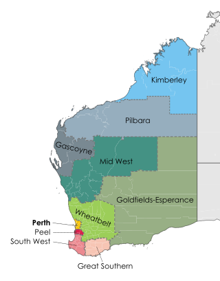
The City of Karratha is one of the four local government areas in the Pilbara region of Western Australia. It covers an area of 15,882 square kilometres (6,132 sq mi) and had a population of about 21,500 as at the 2016 Census, most of which is located in its seat of government, the city of Karratha, and the major towns. It was formerly known as the Shire of Roebourne but was renamed and granted city status on 1 July 2014.
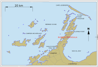
Murujuga, formerly known as Dampier Island and today usually known as the Burrup Peninsula, is an area in the Dampier Archipelago, in the Pilbara region of Western Australia, containing the town of Dampier. The Dampier Rock Art Precinct, which covers the entire archipelago, is the subject of ongoing political debate due to historical and proposed industrial development. Over 40% of Murujuga lies within Murujuga National Park, which contains within it the world's largest collection of ancient 40,000 year old rock art (petroglyphs).
Karratha Airport is an airport in Karratha, in the Pilbara region of Western Australia. The airport is 14 km (8.7 mi) from Karratha and 5 nautical miles south of Dampier.
Pilbara newspapers is a selection of newspapers published in the Pilbara region of Western Australia.
ABC Pilbara is an ABC Local Radio station based in Karratha. Formerly known as ABC North West WA, the station broadcasts to the Gascoyne and parts of the Pilbara regions of Western Australia. This includes the towns of Port Hedland, Carnarvon, Exmouth, Newman and Tom Price.
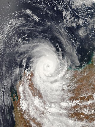
Severe Tropical Cyclone Clare was a moderately strong cyclone that struck Western Australia in January 2006. The storm formed as an area of low pressure in the Arafura Sea, and moved westward. After receiving the name Clare on 7 January, the system ultimately peaked at Category 3 intensity on the Australian tropical cyclone scale. It moved ashore on the coast of the Pilbara and proceeded inland, dissipating on 10 January. Clare produced winds of 142 km/h (88 mph) at Karratha and triggered widespread torrential rainfall that led to flooding. Following its usage, the name Clare was retired by the Bureau of Meteorology, and will never be used again for a tropical cyclone in the area.
Iron ore mining in Western Australia, in the 2018–19 financial year, accounted for 54 percent of the total value of the state's resource production, with a value of A$78.2 billion. The overall value of the minerals and petroleum industry in Western Australia was A$145 billion in 2018–19, a 26 percent increase on the previous financial year.
Ngarluma and Kariyarra are members of a dialect continuum, which is a part of the Ngayarda language group of Western Australia, in the Pama–Nyungan language family. Some sources suggest that an extinct dialect, Jaburara, was a third member of the continuum. However, it is clear that Jaburara had a distinct identity that has been partly obscured by a collapse in the numbers of Jaburara speakers during the late 19th century, and there is some evidence that Jaburara may have instead been a dialect of Martuthunira.
Port Walcott, formerly known as Tien Tsin Harbour, is a large open water harbour located on the northwest coast of Western Australia, located near the town of Point Samson.
Main Roads Western Australia controls the major roads in the state's Pilbara region. There are two main highways in the region: Great Northern Highway, which travels north through the region to Port Hedland and then north-west along the coast, as well as North West Coastal Highway, which heads south-west from Port Hedland. A series of main roads connects towns to the highways, and local roads provide additional links. The majority of these roads service the western half of the region, with few located in the various deserts east of the Oakover River. Roads are often named after the towns or areas they connect.
The Pilbara Coast is the coastline of Western Australia's Pilbara region. It is often referred to as the North West Coast of Western Australia.
The Yapurarra or Jaburara, also rendered Yaburara, are an Aboriginal Australian people whose traditional lands are in the Pilbara region of Western Australia and the Dampier Archipelago.
The Ngarluma are an Indigenous Australian people of the western Pilbara area of northwest Australia. They are coastal dwellers of the area around Roebourne and Karratha, not including Millstream.
The Yindjibarndi are an Aboriginal Australian people of the Pilbara region of Western Australia. They form the majority of Aboriginal people around Roebourne. Their traditional lands lie around the Fortescue River.
The Ngurrara and Ngururrpa are overlapping groupings of Aboriginal Australian peoples of the Great Sandy Desert, in the central Pilbara and southern Kimberley regions of Western Australia. Both groups are represented by various Aboriginal corporations which look after their native title interests.
Severe Tropical Cyclone Damien was the strongest cyclone to make landfall on the Western Australian coast since Cyclone Christine in 2013 and the second-strongest cyclone in the 2019–20 Australian region cyclone season after Cyclone Ferdinand. The fifth tropical low, and the third named storm of the 2019–20 Australian region cyclone season, Damien originated from a monsoon trough over Kimberley.
This page is based on this Wikipedia article Text is available under the CC BY-SA 4.0 license; additional terms may apply. Images, videos and audio are available under their respective licenses.