Goldsworthy, Western Australia

Last updated

Goldsworthy
Western Australia
Mount Goldsworthy Knob W.jpg
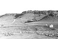
1964 photograph showing iron ore outcrops on the top of Mount Goldsworthy before mining commenced
Australia Western Australia location map.svg
Red pog.svg
Goldsworthy
Goldsworthy, Western Australia
Coordinates 20°20′31″S119°31′06″E / 20.34194°S 119.51833°E / -20.34194; 119.51833
Established1965
Elevation46 m (151 ft)
Location
LGA(s) Shire of East Pilbara
State electorate(s) Pilbara
Federal division(s) Durack

Goldsworthy (named after the geographical feature Mount Goldsworthy) is a former mining town in Western Australia, east of Port Hedland and located in the Shire of East Pilbara. It was the first [1] iron ore mine in the Pilbara region of Western Australia.

Contents

Early discoveries

The explorer Francis Thomas Gregory reported seeing iron ore in the region during his Pilbara explorations in late 1861 [2] and the Government Geologist H.P. Woodward confirmed the discovery of iron ore there in 1890. [3] In 1919 Government Geologist Andrew Gibb Maitland confirmed these deposits but at the time mining them was not an economically viable proposition. [2]

In 1938 Geological Survey of Western Australia geologists Kevin Finucane and Robert Telford surveyed Mount Goldsworthy and reported preliminary estimates of more than 6,000,000 tons of iron ore at 65.66% iron. [2] In the lead up to the Second World War, due to the classification of iron as a strategic material the Commonwealth of Australia placed an embargo on the export of ore. The export embargo was lifted in December 1960 and competition to develop the mine commenced in earnest with the government intending to issue an export licence for ore mined at the site.

Frank Thompson Jr, owner of Pardoo Station had established wells, windmills and paddocks in the area and also pegged mining leases there as they were on the southern end of the station, but he allowed these leases to lapse because of this embargo.

The granting of the export licence did not go without controversy. Ernie Mitchell, chairman of directors of an indigenous corporation known as the Pindan Group, called for an iron ore export licence to be issued to his organisation. Mitchell argued in a pamphlet issued in the early 1960s that: [4]

The granting of an export licence [for iron ore from Mount Goldsworthy] to us, the only successful self-contained Aboriginal group in Australia, would go a long way towards silencing the many critics of Australia's policy towards the original Australians.

Furthermore: We do not ask for an export licence on terms different from those that would be applied to other persons or groups. We do ask that the following facts be considered:

  1. We are lifetime residents of the district.
  2. We have the mining skills, and the workforce necessary to handle the project.
  3. We are familiar with the problems that may arise, and have experience of solving such problems in recent years. We have been basically responsible for producing many thousands of tons of valuable minerals.
  4. We can make arrangements equivalent to those of any other sound business concern, and we have a pool of labour, resident in the district, and accustomed to working in the climatic and other arduous conditions of the Mount Goldsworthy area.
  5. We are aware, as all Australians should be, that our country’s policy in New Guinea towards the natives, and in Australia towards us, has been vigorously attacked in the councils of the United Nations Organisation ... We feel to grant us, the Aboriginal people of the Pindan Group, an iron ore export licence, would go a long way towards convincing such critics of our Government's sincerity and goodwill towards us, and would be a major contribution to the realisation of our plans to raise our standards to the level of our white fellow Australians by enterprise and hard work. We do not seek charity.

Early development of the mine

In February 1962, three international mining companies: the British-owned Consolidated Goldfields (Aust) Pty Ltd, Cyprus Mines Corporation of Los Angeles and Utah Construction & Mining Company [5] [6] of San Francisco, formed Mount Goldsworthy Mining Associates (GML). The consortium was granted an export licence in early 1963 to ship 4 million tonnes of iron ore per year from a port to be built at Finucane Island at Port Hedland, 100 km west.

The consortium signed a contract with Japanese steel mills in February 1965 with a stipulation that the first shipment of ore had to be made within 15 months.

Construction of the port and town commenced in February 1965 and the first rail-delivery of iron ore was made to Finucane Island on 1 December 1965. The first 24,900 tonnes of ore was loaded at Finucane Island onto Harvey S. Mudd on 26 June 1966. [7] The mine was hit by Cyclone Amy in 1980 but it was rebuilt.

700 people lived in 200 houses at Goldsworthy at its peak. The mine at Goldsworthy was closed on 22 December 1982 and mining operations ceased at Shay Gap in 1993. The town was abandoned in 1992. Upon closure, all buildings were removed, all vegetation not indigenous to the local area was burnt, and the roads torn up. This was done in accordance with the government's policy of regrowth to avoid the occurrence of ghost towns. [8] [9]

Today, very little remains on the site to indicate that the town ever existed. The pit that was the mine still exists, but is flooded. The railway to other mines passes nearby, and there is a (solar powered) radio repeater site to service the railway. The street layout can still be seen from the air.

Climate

Climate data for Goldsworthy
MonthJanFebMarAprMayJunJulAugSepOctNovDecYear
Record high °C (°F)48.5
(119.3)
47.8
(118.0)
46.0
(114.8)
43.1
(109.6)
39.9
(103.8)
34.3
(93.7)
35.6
(96.1)
37.7
(99.9)
42.1
(107.8)
44.4
(111.9)
48.0
(118.4)
47.1
(116.8)
48.5
(119.3)
Average high °C (°F)39.6
(103.3)
38.8
(101.8)
38.7
(101.7)
36.5
(97.7)
31.6
(88.9)
28.3
(82.9)
28.0
(82.4)
30.5
(86.9)
34.3
(93.7)
37.6
(99.7)
39.5
(103.1)
40.4
(104.7)
35.3
(95.5)
Average low °C (°F)26.5
(79.7)
26.3
(79.3)
26.1
(79.0)
23.8
(74.8)
19.7
(67.5)
16.6
(61.9)
15.0
(59.0)
16.5
(61.7)
19.0
(66.2)
21.5
(70.7)
23.7
(74.7)
25.3
(77.5)
21.7
(71.1)
Record low °C (°F)20.5
(68.9)
19.1
(66.4)
18.9
(66.0)
16.1
(61.0)
12.2
(54.0)
8.7
(47.7)
6.9
(44.4)
9.2
(48.6)
12.2
(54.0)
15.1
(59.2)
16.3
(61.3)
17.5
(63.5)
6.9
(44.4)
Average precipitation mm (inches)67.6
(2.66)
93.9
(3.70)
57.9
(2.28)
15.0
(0.59)
23.1
(0.91)
19.0
(0.75)
9.8
(0.39)
3.9
(0.15)
1.3
(0.05)
2.5
(0.10)
2.3
(0.09)
28.0
(1.10)
329.7
(12.98)
Average precipitation days6.38.04.31.52.11.91.00.40.20.20.32.525.7
Average relative humidity (%)35373224272722211719212726
Source: [10]

Related Research Articles

The Pilbara is a large, dry, thinly populated region in the north of Western Australia. It is known for its Aboriginal peoples; its ancient landscapes; the red earth; and its vast mineral deposits, in particular iron ore. It is also a global biodiversity hotspot for subterranean fauna.

<span class="mw-page-title-main">Port Hedland, Western Australia</span> Town in Western Australia

Port Hedland is the second largest town in the Pilbara region of Western Australia, with an urban population of 15,298 as of the 2021 census, including the satellite town of South Hedland, 18 kilometres (11 mi) away. It is also the site of the highest tonnage port in Australia.

<span class="mw-page-title-main">South Hedland, Western Australia</span> Suburb of Port Hedland, Western Australia

South Hedland or Port Hedland City Centre is a suburb of the Town of Port Hedland, in the Pilbara region in north-western Western Australia. It is the CBD of the Town of Port Hedland and is the Port Hedland Town Centre. It can be reached by the North West Coastal Highway and Great Northern Highway. It contains Hedland Senior High School.

<span class="mw-page-title-main">Pilbara newspapers</span> Newspapers published in the Pilbara region of Western Australia

Pilbara newspapers is a selection of newspapers published in the Pilbara region of Western Australia.

<span class="mw-page-title-main">Goldsworthy railway</span> Private railway in Pilbara region of Western Australia

The Goldsworthy railway, owned and operated by BHP, is a private rail network in the Pilbara region of Western Australia built to carry iron ore. It is one of two railway lines BHP operates in the Pilbara, the other being the Mount Newman railway.

<span class="mw-page-title-main">Mount Newman railway</span> Private railway in Pilbara region of Western Australia

The Mount Newman railway, owned and operated by BHP, is a private rail network in the Pilbara region of Western Australia built to carry iron ore. It is one of two railway lines BHP operates in the Pilbara, the other being the Goldsworthy railway.

<span class="mw-page-title-main">Mount Whaleback mine</span> Iron ore mine in Western Australia

The Mount Whaleback mine, officially the Newman West operation, is an iron ore mine located in the Pilbara region of Western Australia, six kilometres west of Newman.

<span class="mw-page-title-main">Iron ore mining in Western Australia</span> Mining in Western Australia

Iron ore mining in Western Australia, in the 2018–19 financial year, accounted for 54 percent of the total value of the state's resource production, with a value of A$78.2 billion. The overall value of the minerals and petroleum industry in Western Australia was A$145 billion in 2018–19, a 26 percent increase on the previous financial year.

The Area C mine is an iron ore mine located in the Pilbara region of Western Australia, 92 kilometres west-north-west of Newman.

The Jimblebar mine is an iron ore mine located in the Pilbara region of Western Australia, 41 kilometres east of Newman.

The Pardoo mine was an iron ore mine located in the Pilbara region of Western Australia, 75 kilometres east of Port Hedland.

The Wodgina mine is an exhausted iron ore mine located in the Pilbara region of Western Australia, 90 kilometres south of Port Hedland.

The Yarrie mine is an iron ore mine located in the Pilbara region of Western Australia, 90 kilometres north-east of Marble Bar.

<span class="mw-page-title-main">Yandi mine</span> Iron ore mine in Western Australia

The Yandi mine is an iron ore mine located in the Pilbara region of Western Australia, 90 kilometres north-west of Newman. It should not be confused with Rio Tinto's nearby Yandicoogina mine, which is also sometimes shortened to Yandi.

The Orebodies 18, 23 and 25 mine, part of BHP's Eastern Ridge hub and officially referred to as the Newman East operation, is an iron ore mine located in the Pilbara region of Western Australia, 8 kilometres east of Newman. The mine is majority-owned and operated by BHP, and is one of seven iron ore mines the company operates in the Pilbara. The company also operates two port facilities at Port Hedland, Nelson Point and Finucane Island, and over 1,000 kilometres of rail in the Pilbara.

<span class="mw-page-title-main">Port of Port Hedland</span> Port in Australia

Port Hedland is one of the largest iron ore loading ports in the world and the largest in Australia. In 2022, it had the largest bulk cargo throughput in Australia. With the neighboring ports of Port Walcott and Dampier, Port Hedland is one of three major iron ore exporting ports in the Pilbara region of Western Australia,

The Railways in the Pilbara are a collection of railways in the Pilbara region of north-west Western Australia.

Mineral Resources Limited is a Western Australian mining services company.

The Mt Webber mine is an iron ore mine operated by Atlas Iron and located in the Pilbara region of Western Australia, 230 kilometres (140 mi) from Port Hedland, to where the ore is transported. Mt Webber, opened in 2014, is the company's primary operation.

<span class="mw-page-title-main">Roy Hill railway</span> Private railway in Pilbara region of Western Australia

The Roy Hill railway, officially the Roy Hill Infrastructure railway, owned and operated by Hancock Prospecting, is a private rail network in the Pilbara region of Western Australia built to carry iron ore.

References

  1. Schubert, Leslie A.(1994), Wiping Out the Tracks – The Northern Odyssey: A Family Biography & Social Commentary, ISBN   0646178938.
  2. 1 2 3 Hardie, J 1981: Nor'westers of the Pilbara breed, Shire of Port Hedland, ISBN   0-9594155-0-5, p. 235
  3. "Towns that need to be remembered". GWN. 31 August 2009.
  4. Indigenous accumulation and the question of land in the Kimberley Region of Western Australia: PRE 1968-1975 Archived 2010-06-16 at the Wayback Machine by: Tony Smith, University of Western Sydney, accessed: 27 May 2010
  5. "Iron Ore (Mount Goldsworthy) Agreement Act 1964". Western Australian Legislation. Parliamentary Counsel’s Office, Government of Western Australia. 1964. Retrieved 5 April 2019.
  6. "Utah Development profit reflects Japanese price rise". Sydney Morning Herald . 11 December 1973. p. 20. Retrieved 1 October 2012.
  7. Hardie, J 1981: Nor'westers of the Pilbara breed, Shire of Port Hedland, ISBN   0-9594155-0-5, p. 247
  8. BHP Billiton Limited (3 October 2005). "Form 20-F – Annual Report pursuant to Section 13 or 15 (d) of the Securities Exchange Act of 1934 for the fiscal year ended 30 June 2005". New York Stock Exchange . Retrieved 3 November 2013.
  9. Federal Court of Australia (29 July 2010). "Brown (on behalf of the Ngarla People) v State of Western Australia (No 2) [2010] FCA 498". Jade 3.0. BarNetwork Pty Limited. Retrieved 3 November 2013.
  10. "Climate statistics for Goldsworthy, Western Australia". Bureau of Meteorology. Retrieved 9 June 2015.