The Pilbara is a large, dry, thinly populated region in the north of Western Australia. It is known for its Aboriginal peoples; its ancient landscapes; the red earth; and its vast mineral deposits, in particular iron ore. It is also a global biodiversity hotspot for subterranean fauna.

Port Hedland is the second largest town in the Pilbara region of Western Australia, with an urban population of 15,298 as of the 2021 census, including the satellite town of South Hedland, 18 kilometres (11 mi) away. It is also the site of the highest tonnage port in Australia.

Newman, originally named Mount Newman until 1981, is a town in the Pilbara region of Western Australia. It is located about 1,186 kilometres (737 mi) north of Perth, and 9 kilometres (5.6 mi) north of the Tropic of Capricorn. It can be reached by the Great Northern Highway. Newman is a modern mining town, with homes contrasting with the surrounding reddish desert. As of the 2021 census, Newman had a population of 6,456. The Hickman Crater, a meteorite impact crater discovered in 2007, is 35 kilometres (22 mi) north of Newman.
Karratha is a city in the Pilbara region of Western Australia, adjoining the port of Dampier. It is located in the traditional lands and waters of the Ngarluma people, for whom it has been Ngurra (home/Country) for tens of thousands of years. It was established in 1968 to accommodate the processing and exportation workforce of the Hamersley Iron mining company and, in the 1980s, the petroleum and liquefied natural gas operations of the Woodside-operated North West Shelf Venture located on Murujuga. As of the 2021 census, Karratha had an urban population of 17,013. The city's name comes from the cattle station of the same name, which derives from a word in a local Aboriginal language meaning "good country" or "soft earth". More recently, Ngarluma people have indicated the name may actually relate to an early interpretation of "Gardarra", stemming from the sacred site for the whale, located in the Karratha area, called "Gardarrabuga". The city is the seat of government of the City of Karratha, a local government area covering the surrounding region.

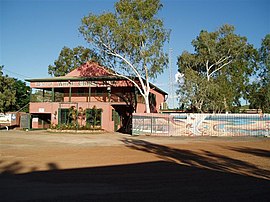
Nullagine is an old goldrush town in Western Australia's Pilbara region. It is located on the Nullagine River 296 km south-east of Port Hedland and 1,364 km north-north-east of Perth on the old Great Northern Highway.

Fortescue is a global metal mining company headquartered in Australia. Fortescue focused on iron ore mining under the name of Fortescue Metals Group (FMG) until July 2023. As of 2017, Fortescue is the fourth-largest iron ore producer in the world. The company has holdings of more than 87,000 km2 in the Pilbara region of Western Australia, making it the largest tenement holder in the state, larger than both BHP and Rio Tinto.
The Whim Creek Copper Mine is a copper oxide mine, located in the City of Karratha in the Pilbara region of Western Australia.
Balla Balla River is a river in the Pilbara region of Western Australia.

The Cloudbreak mine is an iron ore mine located in the Pilbara region of Western Australia, 89 kilometres west-south-west of Nullagine, in the Chichester Range.

Iron ore mining in Western Australia, in the 2018–19 financial year, accounted for 54 percent of the total value of the state's resource production, with a value of A$78.2 billion. The overall value of the minerals and petroleum industry in Western Australia was A$145 billion in 2018–19, a 26 percent increase on the previous financial year.
Ngarluma and Kariyarra are members of a dialect continuum, which is a part of the Ngayarda language group of Western Australia, in the Pama–Nyungan language family. Some sources suggest that an extinct dialect, Jaburara, was a third member of the continuum. However, it is clear that Jaburara had a distinct identity that has been partly obscured by a collapse in the numbers of Jaburara speakers during the late 19th century, and there is some evidence that Jaburara may have instead been a dialect of Martuthunira.
Sherlock Station is a pastoral lease and sheep station located approximately 54 kilometres (34 mi) East of Roebourne in the Pilbara region of Western Australia. Covering an area of 216,700 acres (87,695 ha) pasture, the lease provides good grazing land. In 2015 it was purchased by Bettini Bros, now Bettini Beef, in a package with Mallina and Pyramid Stations. The Bettinis still owned the lease in 2018. Sherlock is operating under the Crown Lease number CL311-1966 and has the Land Act number LA3114/558.

Severe Tropical Cyclone John was an intense tropical cyclone that rapidly deepened offshore before devastating areas of Western Australia. The system was the second cyclone and first severe tropical cyclone of the active 1999–00 Australian region cyclone season. Cyclone John developed from a monsoon trough positioned northwest of Australia on 9 December 1999. As it moved to the west and later south as the result of a subtropical ridge under favourable conditions, the cyclone was able to rapidly intensify. John reached peak intensity on 14 December as a Category 5 cyclone on the Australian cyclone scale, the highest rating possible. Cyclone John later began interacting with a mid–latitude trough, which slightly weakened the cyclone prior to making landfall near Whim Creek early on 15 December. Increasingly unfavourable conditions further inland resulted in the cyclone's rapid weakening, before it dissipated during the next day.
Mount Welcome Station is a pastoral lease that once operated as a sheep station but is now operated as a cattle station in Western Australia.

Severe Tropical Cyclone Lua affected a sparsely populated region of Western Australia during mid-March 2012. Originating in a broad low pressure area that formed northwest of Australia by 8 March, the storm was plagued by inhibiting wind shear for the duration of its formative stages. However, it gradually organised, and received the name Lua on 13 March. The cyclone meandered for the first several days of its existence, caught between weak and competing steering currents. After the cyclone drifted northwestward, a building ridge of high pressure to the north drove Lua southeastward toward the Pilbara region. Ultimately intensifying into an upper-end Category 3 severe tropical cyclone with maximum sustained 10-minute winds of 155 km/h (96 mph), Lua made landfall near the remote community of Pardoo, about 150 km (93 mi) east of Port Hedland. It steadily weakened as it progressed south over interior Western Australia, diminishing below tropical cyclone status on 18 March.

Severe Tropical Cyclone Christine was the third tropical cyclone and the second severe tropical cyclone of the 2013–14 Australian region cyclone season. It made landfall on Western Australia's Pilbara coast nearly halfway between the major towns of Karratha and Port Hedland as a category 4 cyclone on midnight of 31 December 2013.
Balla Balla Station is a pastoral lease and cattle station located approximately 138 kilometres (86 mi) north of Karratha just off the North West Coastal Highway in the Pilbara region of Western Australia.

Severe Tropical Cyclone Heidi was a small and strong tropical cyclone that struck Western Australia in January 2012. The seventh tropical low, third tropical cyclone, and second severe tropical cyclone of the 2011–12 Australian region cyclone season, Heidi developed from a tropical low that formed to the south of Indonesia on 9 January, before strengthening into a Category 1 tropical cyclone on the following day. Tracking southward towards the Pilbara coast in a favourable environment, Heidi rapidly intensified and attained Category 3 severe tropical cyclone status on 11 January. After making landfall at peak intensity later that day with estimated winds of 150 km/h (95 mph), Heidi rapidly weakened, dissipating over Western Australia by 13 January.
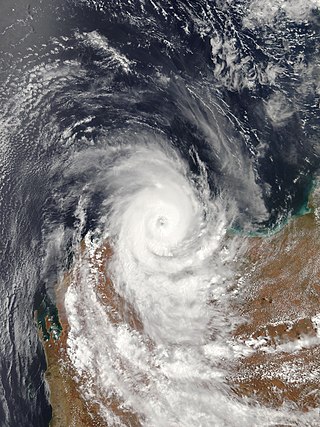
Severe Tropical Cyclone Damien was the strongest cyclone to make landfall on the Western Australian coast since Cyclone Christine in 2013 and the second-strongest cyclone in the 2019–20 Australian region cyclone season after Cyclone Ferdinand. The fifth tropical low, and the third named storm of the 2019–20 Australian region cyclone season, Damien originated from a monsoon trough over Kimberley.
Copper mining in Western Australia is relatively minor on a world scale, accounting for less than one percent of the world's production in 2021–22.