Town of Port Hedland

Last updated

Town of Port Hedland
Western Australia
Port hedland LGA WA.png
Location in Western Australia
Town of Port Hedland
Population15,684 (LGA 2021) [1]
Area10,587 km2 (4,087.7 sq mi)
MayorPeter Carter
Council seat Port Hedland
Region Pilbara
State electorate(s) Pilbara
Federal division(s) Durack
Logo of Town of Port Hedland.svg
Website Town of Port Hedland
LGAs around Town of Port Hedland:
Indian Ocean Indian Ocean East Pilbara
Indian Ocean Town of Port Hedland East Pilbara
Karratha Ashburton East Pilbara

The Town of Port Hedland is a local government area in the Pilbara region of Western Australia containing the twin settlements of Port Hedland and South Hedland and the industrial precinct of Wedgefield. It had a population of approximately 14,500 as at the 2016 Census of which only a few hundred live outside the settlement boundaries. [2]

Contents

History

The Pilbara Road District was gazetted on 22 June 1894. It lost some territory to the new Nullagine Road District on 8 July 1898. It was renamed the Port Hedland Road District on 18 March 1904. [3]

It became the Shire of Port Hedland on 1 July 1961 under the Local Government Act 1960, which reformed all remaining road districts into shires. [3] It underwent substantial boundary changes on 28 April 1972, losing approximately 5,669 square kilometres to the Shire of Marble Bar and gaining approximately 18.3 square kilometres from the Shire of Roebourne. [4] It assumed its current name when it gained town status on 18 March 1989. [3]

In June 2019 the Council was suspended by the state government and replaced with a commissioner. [5]

In October 2019, the government of Western Australia announced that there would be no further residential development of the West End of Port Hedland to protect sensitive population groups from health effects caused by dust generated by Port activities.

Wards

The town has eight councillors and no wards.

Towns and localities

The towns and localities of the Port Hedland with population and size figures based on the most recent Australian census: [6] [7]

LocalityPopulationAreaMap
Boodarie 182 (SAL 2021 ) [8] 862.2 km2 (332.9 sq mi) Town of Port Hedland
De Grey 24 (SAL 2021 ) [9] 3,167.6 km2 (1,223.0 sq mi) Town of Port Hedland
Finucane 0 (SAL 2016 ) [10] [11] 1.9 km2 (0.73 sq mi) Town of Port Hedland
Indee 16 (SAL 2021 ) [12] 1,624 km2 (627 sq mi) Town of Port Hedland
Marble Bar *927 (SAL 2021 ) [13] 35,032.9 km2 (13,526.3 sq mi) Town of Port Hedland
Mundabullangana 14 (SAL 2021 ) [14] 2,632 km2 (1,016 sq mi) Town of Port Hedland
Pippingarra 49 (SAL 2021 ) [15] 882.5 km2 (340.7 sq mi) Town of Port Hedland
Port Hedland 4,081 (SAL 2021 ) [16] 75.1 km2 (29.0 sq mi) Town of Port Hedland
Redbank 48 (SAL 2021 ) [17] 9.5 km2 (3.7 sq mi) Town of Port Hedland
South Hedland 11,046 (SAL 2021 ) [18] 22.3 km2 (8.6 sq mi) Town of Port Hedland
Strelley 41 (SAL 2021 ) [19] 809.6 km2 (312.6 sq mi) Town of Port Hedland
Wallareenya 0 (SAL 2016 ) [20] [21] 608.3 km2 (234.9 sq mi) Town of Port Hedland
Wedgefield 127 (SAL 2021 ) [22] 20.1 km2 (7.8 sq mi) Town of Port Hedland

Former towns

Heritage-listed places

As of 2021, 81 places are heritage-listed in the Town of Port Hedland, [23] of which six are on the State Register of Heritage Places. [24]

Related Research Articles

<span class="mw-page-title-main">Shire of Ashburton</span> Local government area in Western Australia

The Shire of Ashburton is one of the four local government areas in the Pilbara region of Western Australia, covering an area of 105,647 square kilometres (40,791 sq mi). It is named after the Ashburton River.

<span class="mw-page-title-main">Shire of East Pilbara</span> Local government area in Western Australia

The Shire of East Pilbara is one of the four local government areas in the Pilbara region of Western Australia. With an area of 372,571 square kilometres (143,850 sq mi), larger than the Australian states of Victoria and Tasmania combined, it is the largest local government region in Australia. The Shire's seat of government, and home to nearly half the Shire's population, is the town of Newman in the shire's south-west.

<span class="mw-page-title-main">Shire of Coolgardie</span> Local government area in Western Australia

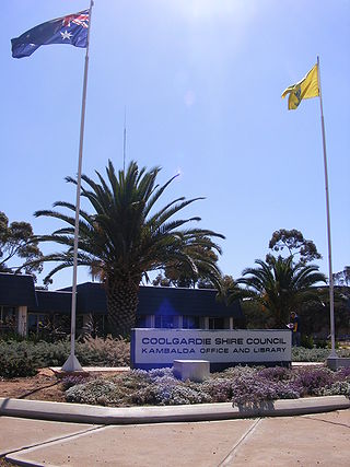
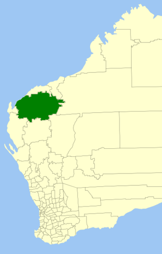
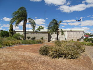
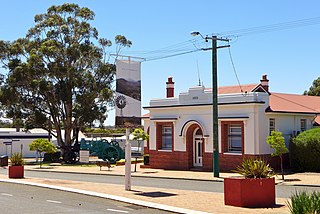
The Shire of Coolgardie is a local government area in the Goldfields–Esperance region of Western Australia, lying roughly west and south of the city of Kalgoorlie. The Shire covers an area of 30,400 square kilometres (11,738 sq mi), and its seat of government is the town of Coolgardie, although the twin towns of Kambalda East and Kambalda West contain two-thirds of the Shire's population.

<span class="mw-page-title-main">Shire of Waroona</span> Local government area in Western Australia

The Shire of Waroona is a local government area in the Peel region of Western Australia between Mandurah and Harvey and about 110 kilometres (68 mi) south of Perth, the state capital. The Shire covers an area of about 835 km² (322 mi²) and its seat of government is the town of Waroona.

<span class="mw-page-title-main">Shire of Boddington</span> Local government area in Western Australia

The Shire of Boddington is a local government area in the Peel region of Western Australia, about 120 kilometres (75 mi) south-east of the state capital, Perth. The Shire covers an area of 1,901 square kilometres (734 sq mi), and its seat of government is the town of Boddington.

<span class="mw-page-title-main">Shire of Broome</span> Local government area in Western Australia

The Shire of Broome is one of the four local government areas in the Kimberley region of northern Western Australia, covering an area of 55,796 square kilometres (21,543 sq mi), most of which is sparsely populated. The Shire's estimated population as at the 2016 census was 16,222 most of whom reside in the town of Broome. Many Aboriginal communities are within the Shire, notably Beagle Bay and Bardi.

<span class="mw-page-title-main">Shire of Dundas</span> Local government area in Western Australia

The Shire of Dundas is a local government area in the Goldfields-Esperance region of Western Australia. The shire covers an area of 93,179 square kilometres (35,977 sq mi) and its seat of government is the town of Norseman. Its territory lies between Norseman and the border with South Australia, and is between 700 and 1,500 kilometres east of the state capital, Perth.

<span class="mw-page-title-main">Shire of Kojonup</span> Local government area in the Great Southern region of Western Australia

The Shire of Kojonup is a local government area in the Great Southern region of Western Australia, about 250 kilometres (155 mi) southeast of the state capital, Perth, along Albany Highway. The Shire covers an area of 2,932 square kilometres (1,132 sq mi) and its seat of government is the town of Kojonup.

<span class="mw-page-title-main">Shire of Wyalkatchem</span> Local government area in the Wheatbelt region of Western Australia

The Shire of Wyalkatchem is a local government area located in the Wheatbelt region of Western Australia. Its seat of government is the town of Wyalkatchem, about 190 kilometres (118 mi) northeast of Perth, the state capital.

<span class="mw-page-title-main">Shire of Coorow</span> Local government area in the Mid West region of Western Australia

The Shire of Coorow is a local government area located in the Mid West region of Western Australia, about 290 kilometres (180 mi) north of Perth, the state capital, and about 130 kilometres (80 mi) south of the city of Geraldton. The Shire covers an area of 4,194 square kilometres (1,619 sq mi) and its seat of government is the town of Coorow, with the largest settlement being Leeman.

<span class="mw-page-title-main">Shire of Gnowangerup</span> Local government area in the Great Southern region of Western Australia

The Shire of Gnowangerup is a local government area in the Great Southern region of Western Australia, about 120 kilometres (75 mi) north of Albany and about 370 kilometres (230 mi) southeast of the capital, Perth. The Shire covers an area of 4,268 square kilometres (1,648 sq mi), and its seat of government is the town of Gnowangerup.

<span class="mw-page-title-main">Shire of Carnarvon</span> Local government area in Western Australia

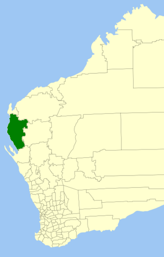
The Shire of Carnarvon is a local government area in the Gascoyne region of Western Australia, located about 900 kilometres (560 mi) north of the state capital, Perth. The Shire covers an area of 46,664 square kilometres (18,017 sq mi), and its seat of government is the town of Carnarvon. The major industries in the area are wool, agriculture and, more recently, tourism.

<span class="mw-page-title-main">Shire of Cranbrook</span> Local government area in Western Australia

The Shire of Cranbrook is a local government area in the Great Southern region of Western Australia, about 92 kilometres (57 mi) north of Albany and about 320 kilometres (200 mi) south-southeast of the state capital, Perth. The Shire covers an area of 3,277 square kilometres (1,265 sq mi), and its seat of government is the town of Cranbrook.

<span class="mw-page-title-main">Shire of Denmark</span> Local government area in Western Australia

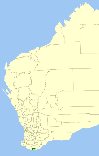
The Shire of Denmark is a local government area in the Great Southern region of Western Australia, about 55 kilometres (34 mi) west of Albany and about 420 kilometres (261 mi) south-southeast of the state capital, Perth. The Shire of Denmark covers an area of 1,860 square kilometres (718 sq mi), and its seat of government is located in the townsite and locality of Denmark.

<span class="mw-page-title-main">Shire of Exmouth</span> Local government area in Western Australia

The Shire of Exmouth is a local government area in the Gascoyne region of Western Australia, about 1,000 kilometres (600 mi) north of the state capital, Perth. The Shire covers an area of 6,503 square kilometres (2,511 sq mi), and its seat of government is the town of Exmouth.

<span class="mw-page-title-main">Shire of Jerramungup</span> Local government area in the Great Southern region of Western Australia

The Shire of Jerramungup is a local government area in the Great Southern region of Western Australia, about 180 kilometres (112 mi) northeast of Albany and about 440 kilometres (273 mi) southeast of the state capital, Perth. The Shire covers an area of 6,507 square kilometres (2,512 sq mi) with Bremer Bay its largest town. The seat of government is the town of Jerramungup.

<span class="mw-page-title-main">Shire of Katanning</span> Local government area in Western Australia

The Shire of Katanning is a local government area in the Great Southern region of Western Australia, about 170 kilometres (106 mi) north of Albany and about 290 kilometres (180 mi) southeast of the state capital, Perth. The Shire covers an area of 1,518 square kilometres (586 sq mi), and its seat of government is the town of Katanning.

<span class="mw-page-title-main">Shire of Laverton</span> Local government area in Western Australia

The Shire of Laverton is a local government area in the Goldfields-Esperance region of Western Australia, about 370 kilometres (230 mi) northeast of the city of Kalgoorlie and about 950 kilometres (590 mi) east-northeast of the state capital, Perth. The Shire covers an area of 179,798 square kilometres (69,420 sq mi), and its seat of government is the town of Laverton.

<span class="mw-page-title-main">Shire of Ravensthorpe</span> Local government area in Western Australia

The Shire of Ravensthorpe is a local government area in the southern Goldfields-Esperance region of Western Australia, about halfway between the city of Albany and the town of Esperance and about 530 kilometres (329 mi) southeast of the state capital, Perth. The Shire covers an area of 13,551 square kilometres (5,232 sq mi), and its seat of government is the town of Ravensthorpe.

<span class="mw-page-title-main">Shire of Woodanilling</span> Local government area in the Great Southern region of Western Australia

The Shire of Woodanilling is a local government area in the Great Southern region of Western Australia, about 30 kilometres (19 mi) south of Wagin and about 260 kilometres (162 mi) south-southeast of the state capital, Perth. The Shire covers an area of 1,129 square kilometres (436 sq mi), and its seat of government is the town of Woodanilling.

References

  1. Australian Bureau of Statistics (28 June 2022). "Port Hedland (Local Government Area)". Australian Census 2021 QuickStats. Retrieved 28 June 2022.  OOjs UI icon edit-ltr-progressive.svg
  2. Australian Bureau of Statistics (27 June 2017). "Port Hedland (Urban Centre/Locality)". 2016 Census QuickStats. Retrieved 26 November 2017. OOjs UI icon edit-ltr-progressive.svg
  3. 1 2 3 "Municipality Boundary Amendments Register" (PDF). Western Australian Electoral Distribution Commission. Retrieved 11 January 2020.
  4. "Friday, 28th April 1972" (PDF). Government Gazette of Western Australia. Retrieved 25 January 2020.
  5. McNeill, Heather (9 July 2019). "Entire Town of Port Hedland Council suspended over ongoing complaints". WA Today.
  6. "SLIP Map". maps.slip.wa.gov.au. Landgate . Retrieved 9 January 2023.
  7. "NationalMap". nationalmap.gov.au. Geoscience Australia . Retrieved 9 January 2023.
  8. Australian Bureau of Statistics (28 June 2022). "Boodarie (Suburb and Locality)". Australian Census 2021 QuickStats. Retrieved 28 June 2022.  OOjs UI icon edit-ltr-progressive.svg
  9. Australian Bureau of Statistics (28 June 2022). "De Grey (Suburb and Locality)". Australian Census 2021 QuickStats. Retrieved 28 June 2022.  OOjs UI icon edit-ltr-progressive.svg
  10. Australian Bureau of Statistics (27 June 2017). "Finucane (Suburb and Locality)". Australian Census 2016.  OOjs UI icon edit-ltr-progressive.svg
  11. Australian Bureau of Statistics (27 June 2017). "Finucane (Suburb and Locality)". Australian Census 2016 QuickStats. Retrieved 28 June 2022.  OOjs UI icon edit-ltr-progressive.svg
  12. Australian Bureau of Statistics (28 June 2022). "Indee (Suburb and Locality)". Australian Census 2021 QuickStats. Retrieved 28 June 2022.  OOjs UI icon edit-ltr-progressive.svg
  13. Australian Bureau of Statistics (28 June 2022). "Marble Bar (Suburb and Locality)". Australian Census 2021 QuickStats. Retrieved 28 June 2022.  OOjs UI icon edit-ltr-progressive.svg
  14. Australian Bureau of Statistics (28 June 2022). "Mundabullangana (Suburb and Locality)". Australian Census 2021 QuickStats. Retrieved 28 June 2022.  OOjs UI icon edit-ltr-progressive.svg
  15. Australian Bureau of Statistics (28 June 2022). "Pippingarra (Suburb and Locality)". Australian Census 2021 QuickStats. Retrieved 28 June 2022.  OOjs UI icon edit-ltr-progressive.svg
  16. Australian Bureau of Statistics (28 June 2022). "Port Hedland (Suburb and Locality)". Australian Census 2021 QuickStats. Retrieved 28 June 2022.  OOjs UI icon edit-ltr-progressive.svg
  17. Australian Bureau of Statistics (28 June 2022). "Redbank (WA) (Suburb and Locality)". Australian Census 2021 QuickStats. Retrieved 28 June 2022.  OOjs UI icon edit-ltr-progressive.svg
  18. Australian Bureau of Statistics (28 June 2022). "South Hedland (Suburb and Locality)". Australian Census 2021 QuickStats. Retrieved 28 June 2022.  OOjs UI icon edit-ltr-progressive.svg
  19. Australian Bureau of Statistics (28 June 2022). "Strelley (Suburb and Locality)". Australian Census 2021 QuickStats. Retrieved 28 June 2022.  OOjs UI icon edit-ltr-progressive.svg
  20. Australian Bureau of Statistics (27 June 2017). "Wallareenya (Suburb and Locality)". Australian Census 2016.  OOjs UI icon edit-ltr-progressive.svg
  21. Australian Bureau of Statistics (27 June 2017). "Wallareenya (Suburb and Locality)". Australian Census 2016 QuickStats. Retrieved 28 June 2022.  OOjs UI icon edit-ltr-progressive.svg
  22. Australian Bureau of Statistics (28 June 2022). "Wedgefield (Suburb and Locality)". Australian Census 2021 QuickStats. Retrieved 28 June 2022.  OOjs UI icon edit-ltr-progressive.svg
  23. "Town of Port Hedland Heritage Places". inherit.stateheritage.wa.gov.au. Heritage Council of Western Australia. Retrieved 12 March 2021.
  24. "Town of Port Hedland State Register of Heritage Places". inherit.stateheritage.wa.gov.au. Heritage Council of Western Australia. Retrieved 12 March 2021.

Coordinates: 20°18′36″S118°36′04″E / 20.310°S 118.601°E / -20.310; 118.601