Shire of Beverley

Last updated • 2 min readFrom Wikipedia, The Free Encyclopedia

Shire of Beverley
Western Australia
Beverley Town Hall, 2018 (01).jpg
Beverley Town Hall, 2018
Beverley LGA WA.png
Location in Western Australia
Shire of Beverley
Population1,694 (LGA 2021) [1]
Established1871
Area2,372.2 km2 (915.9 sq mi)
Shire PresidentDavid White
Council seat Beverley
Region Wheatbelt
State electorate(s) Central Wheatbelt
Federal division(s) Pearce
Beverley logo.png
Website Shire of Beverley
LGAs around Shire of Beverley:
Kalamunda York Quairading
Armadale Shire of Beverley Quairading
Wandering Brookton Brookton

The Shire of Beverley is a local government area in the Wheatbelt region of Western Australia about 130 kilometres (80 mi) southeast of Perth, the state capital. The Shire covers an area of 2,372 square kilometres (916 sq mi), starting 20 kilometres (12 mi) outside Armadale in the Darling Scarp and extending eastwards beyond the scarp into agricultural lands which support broad acre activities such as livestock and cropping. Its seat of government is the town of Beverley, which accommodates just over half of the Shire's population.

Contents

History

The Beverley Road District was proclaimed on 24 January 1871. [2] It was initially far larger on its eastern and southern sides than the present shire, extending east to the colonial border. [3]

The township of Beverley itself was separated as the Municipality of Beverley on 31 March 1892 and the East Beverley Road District separated on 18 October 1895. [2] [4]

The Brookton Road District was separated from Beverley on 26 April 1906. [5] However, on 27 April 1906, the East Beverley district was abolished, partially re-absorbed into Beverley and partially into the new Brookton board. [2] [6]

The Municipality of Beverley was re-absorbed into the road district on 4 April 1913. [2]

It was declared a shire and named the Shire of Beverley with effect from 1 July 1961 following the passage of the Local Government Act 1960, which reformed all remaining road districts into shires. [2]

Wards

The Shire is divided into three wards, which became effective on 2 May 1987. [7]

Prior to 1986, the Shire was represented by eight councillors across four wards which had existed in some form since the amalgamation of the Municipal District in 1913: [2]

Towns and localities

The towns and localities of the Shire of Beverley with population and size figures based on the most recent Australian census: [8] [9]

LocalityPopulationAreaMap
Bally Bally 54 (SAL 2021 ) [10] 184.5 km2 (71.2 sq mi) Shire of Beverley
Beverley 1,109 (SAL 2021 ) [11] 384.1 km2 (148.3 sq mi) Shire of Beverley
Dale 190 (SAL 2021 ) [12] 399.9 km2 (154.4 sq mi) Shire of Beverley
East Beverley 96 (SAL 2016 ) [13] [14] 254.3 km2 (98.2 sq mi) Shire of Beverley
Flint 0 (SAL 2016 ) [15] [16] 568.7 km2 (219.6 sq mi) Shire of Beverley
Kokeby 90 (SAL 2021 ) [17] 199.9 km2 (77.2 sq mi) Shire of Beverley
Morbinning 36 (SAL 2021 ) [18] 147.2 km2 (56.8 sq mi) Shire of Beverley
Talbot West 26 (SAL 2021 ) [19] 55.9 km2 (21.6 sq mi) Shire of Beverley
Westdale 93 (SAL 2021 ) [20] 174.2 km2 (67.3 sq mi) Shire of Beverley

Population

Historical population
YearPop.±% p.a.
1921 1,882    
1933 1,992+0.47%
1947 1,629−1.43%
1954 1,968+2.74%
1961 1,899−0.51%
1966 1,773−1.36%
1971 1,628−1.69%
1976 1,577−0.63%
1981 1,554−0.29%
YearPop.±% p.a.
1986 1,502−0.68%
1991 1,433−0.94%
1996 1,399−0.48%
2001 1,461+0.87%
2006 1,562+1.35%
2011 1,567+0.06%
2016 1,745+2.18%
2021 1,694−0.59%

Notable councillors

Heritage-listed places

As of 2023, 95 places are heritage-listed in the Shire of Beverley, [21] of which 18 are on the State Register of Heritage Places. [22]

Related Research Articles

<span class="mw-page-title-main">Shire of West Arthur</span> Local government area in Western Australia

The Shire of West Arthur is a local government area in the Wheatbelt region of Western Australia, generally to the west of Albany Highway about 200 kilometres (124 mi) south-east of Perth, the state capital. The Shire covers an area of 2,834 square kilometres (1,094 sq mi) and its seat of government is the town of Darkan. Industries within the Shire, worth approximately $45 million per year to the State's economy, are dominated by wool and sheep, and also include timber, grain, forestry, beef, pigs, cattle hide tanning, engineering and earthmoving.

<span class="mw-page-title-main">Shire of Wongan–Ballidu</span> Local government area in the Wheatbelt region of Western Australia

The Shire of Wongan–Ballidu is a local government area in the Wheatbelt region of Western Australia, about 180 kilometres (112 mi) NNE of Perth, the state capital. The Shire covers an area of 3,369 square kilometres (1,301 sq mi) and its seat of government is the town of Wongan Hills. The shire includes the Wongan Hills, after which the town is named.

<span class="mw-page-title-main">Shire of Victoria Plains</span> Local government area in the Wheatbelt region in Western Australia

The Shire of Victoria Plains is a local government area in the Wheatbelt region of Western Australia, about 160 kilometres (100 mi) north of the state capital, Perth. It covers an area of 2,569 square kilometres (992 sq mi), and its seat of government is the town of Calingiri.

<span class="mw-page-title-main">Shire of Wandering</span> Local government area in the Wheatbelt region of Western Australia

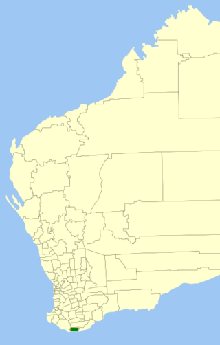
The Shire of Wandering is a local government area in the Wheatbelt region of Western Australia, and, with a population of 444 as at the 2016 census, is one of the nation's smallest. It covers an area of 1,901 square kilometres (734 sq mi) generally to the east of Albany Highway about 120 kilometres (75 mi) south-east of Perth, the state capital. The Shire's seat of government is the town of Wandering.

<span class="mw-page-title-main">Shire of Brookton</span> Local government area in Western Australia

The Shire of Brookton is a local government area in the Wheatbelt region of Western Australia, about 140 kilometres (87 mi) southeast of Perth, the state capital. The Shire covers an area of 1,602 square kilometres (619 sq mi) and its seat of government is the town of Brookton.

<span class="mw-page-title-main">Shire of Dumbleyung</span> Local government area in Western Australia

The Shire of Dumbleyung is a local government area in the Wheatbelt region of Western Australia, about 40 kilometres (25 mi) east of Wagin and about 275 kilometres (171 mi) southeast of Perth, the state capital. The Shire covers an area of 2,540 square kilometres (981 sq mi), and is involved in grain and livestock production and various biodiversity industries including cereals, summer crops, oil mallees, yabbies, emus, poultry and trout. Its seat of government is the town of Dumbleyung.

<span class="mw-page-title-main">Shire of Wickepin</span> Local government area in the Wheatbelt region of Western Australia

The Shire of Wickepin is a local government area in the Wheatbelt region of Western Australia, east of Narrogin and about 220 kilometres (137 mi) southeast of the state capital, Perth. The Shire covers an area of 2,042 square kilometres (788 sq mi), and its seat of government is the town of Wickepin.

<span class="mw-page-title-main">Shire of Pingelly</span> Local government area in Wheatbelt region of Western Australia

The Shire of Pingelly is a local government area in the Wheatbelt region of Western Australia, about 160 kilometres (99 mi) southeast of the state capital, Perth, between the Shires of Brookton and Cuballing along the Great Southern Highway. The Shire covers an area of 1,295 square kilometres (500 sq mi), and its seat of government is the town of Pingelly.

<span class="mw-page-title-main">Shire of Northam</span> Local government area in the Wheatbelt region of Western Australia

The Shire of Northam is a local government area in the Wheatbelt region of Western Australia, beyond the northeastern fringe of the Perth metropolitan area centred on the town of Northam itself. The Shire covers an area of 1,431 square kilometres (553 sq mi). In 2007, it merged with the Town of Northam, almost tripling its population in the process from a previous size of 3,794.

<span class="mw-page-title-main">Shire of Corrigin</span> Local government area in the Wheatbelt region of Western Australia

The Shire of Corrigin is a local government area in the Wheatbelt region of Western Australia, about 230 kilometres (143 mi) east of the state capital, Perth. Its seat of government is the town of Corrigin. The shire covers an area of 3,095 square kilometres (1,195 sq mi) and the economy, worth approximately $50 million per year to the state economy, is based on agriculture - predominantly cereal grains and sheep, with some supporting industries including a flour mill.

<span class="mw-page-title-main">Shire of York</span> Local government area in Western Australia

The Shire of York is a local government area in the Wheatbelt region of Western Australia, covering an area of 2,133 square kilometres (824 sq mi) just beyond the eastern fringe of Perth's metropolitan area. The Shire's seat of government is the town of York.

<span class="mw-page-title-main">Shire of Kojonup</span> Local government area in the Great Southern region of Western Australia

The Shire of Kojonup is a local government area in the Great Southern region of Western Australia, about 250 kilometres (155 mi) southeast of the state capital, Perth, along Albany Highway. The Shire covers an area of 2,932 square kilometres (1,132 sq mi) and its seat of government is the town of Kojonup.

<span class="mw-page-title-main">Shire of Cunderdin</span> Local government area in the Wheatbelt region in Western Australia

The Shire of Cunderdin is a local government area in the Wheatbelt region of Western Australia, about 105 kilometres (65 mi) west of Merredin and about 155 kilometres (96 mi) east of Perth, the state capital. The Shire covers an area of 1,864 square kilometres (720 sq mi), and its seat of government is the town of Cunderdin.

<span class="mw-page-title-main">Shire of Dalwallinu</span> Local government area in the Wheatbelt region of Western Australia

The Shire of Dalwallinu is a local government area in the Wheatbelt region of Western Australia, about 250 kilometres (155 mi) NNE of Perth, the state capital. The Shire covers an area of 7,236 square kilometres (2,794 sq mi) and its seat of government is the town of Dalwallinu.

<span class="mw-page-title-main">Shire of Denmark</span> Local government area in Western Australia

The Shire of Denmark is a local government area in the Great Southern region of Western Australia, about 55 kilometres (34 mi) west of Albany and about 420 kilometres (261 mi) south-southeast of the state capital, Perth. The Shire of Denmark covers an area of 1,860 square kilometres (718 sq mi), and its seat of government is located in the townsite and locality of Denmark.

<span class="mw-page-title-main">Shire of Laverton</span> Local government area in Western Australia

The Shire of Laverton is a local government area in the Goldfields-Esperance region of Western Australia, about 370 kilometres (230 mi) northeast of the city of Kalgoorlie and about 950 kilometres (590 mi) east-northeast of the state capital, Perth. The Shire covers an area of 179,798 square kilometres (69,420 sq mi), and its seat of government is the town of Laverton.

<span class="mw-page-title-main">Shire of Northampton</span> Local government area in Western Australia

The Shire of Northampton is a local government area in the Mid West region of Western Australia, about 50 kilometres (30 mi) north of Geraldton and about 460 kilometres (290 mi) north of the state capital, Perth. The Shire covers an area of 13,738 square kilometres (5,304 sq mi), and its seat of government is the town of Northampton, with the largest settlement being Kalbarri.

<span class="mw-page-title-main">Shire of Perenjori</span> Local government area in Western Australia

The Shire of Perenjori is a local government area in the Mid West region of Western Australia, about 360 kilometres (224 mi) north of the state capital, Perth. The Shire covers an area of 8,313 square kilometres (3,210 sq mi), and its seat of government is the town of Perenjori.

<span class="mw-page-title-main">Shire of Woodanilling</span> Local government area in the Great Southern region of Western Australia

The Shire of Woodanilling is a local government area in the Great Southern region of Western Australia, about 30 kilometres (19 mi) south of Wagin and about 260 kilometres (162 mi) south-southeast of the state capital, Perth. The Shire covers an area of 1,129 square kilometres (436 sq mi), and its seat of government is the town of Woodanilling.

<span class="mw-page-title-main">Shire of Broomehill–Tambellup</span> Local government area in Western Australia

The Shire of Broomehill-Tambellup is a local government area in the Great Southern region of Western Australia, 320 kilometres (200 mi) south-southeast of the state capital, Perth. The Shire covers an area of 2,609.1 square kilometres (1,007.4 sq mi), and its seat of government is the town of Tambellup. It came into existence in 2008 through the amalgamation of the former Shire of Broomehill and Shire of Tambellup.

References

  1. Australian Bureau of Statistics (28 June 2022). "Beverley (Local Government Area)". Australian Census 2021 QuickStats. Retrieved 28 June 2022.  OOjs UI icon edit-ltr-progressive.svg
  2. 1 2 3 4 5 6 "Municipality Boundary Amendments Register" (PDF). Western Australian Electoral Distribution Commission. Retrieved 11 January 2020.
  3. "24 January 1871" (PDF). Government Gazette of South Australia. Retrieved 15 January 2020.
  4. "18 October 1892" (PDF). Government Gazette of Western Australia. Retrieved 15 January 2020.
  5. "BROOKTON NOTES". Western Mail . Western Australia. 31 March 1906. p. 8. Retrieved 15 January 2020 via Trove.
  6. "East Beverley Roads Board". The Beverley Times . Western Australia. 23 June 1906. p. 7. Retrieved 15 January 2020 via Trove.
  7. "Local Government Act 1960 – Shire of Beverley (Ward Boundaries and Representation) Order No.1 1986". Western Australia Government Gazette. 7 November 1986. p. 1986:4164–4165.
  8. "SLIP Map". maps.slip.wa.gov.au. Landgate . Retrieved 5 February 2023.
  9. "NationalMap". nationalmap.gov.au. Geoscience Australia . Retrieved 5 February 2023.
  10. Australian Bureau of Statistics (28 June 2022). "Bally Bally (Suburb and Locality)". Australian Census 2021 QuickStats. Retrieved 28 June 2022.  OOjs UI icon edit-ltr-progressive.svg
  11. Australian Bureau of Statistics (28 June 2022). "Beverley (WA) (Suburb and Locality)". Australian Census 2021 QuickStats. Retrieved 28 June 2022.  OOjs UI icon edit-ltr-progressive.svg
  12. Australian Bureau of Statistics (28 June 2022). "Dale (Suburb and Locality)". Australian Census 2021 QuickStats. Retrieved 28 June 2022.  OOjs UI icon edit-ltr-progressive.svg
  13. Australian Bureau of Statistics (27 June 2017). "East Beverley (Suburb and Locality)". Australian Census 2016.  OOjs UI icon edit-ltr-progressive.svg
  14. Australian Bureau of Statistics (27 June 2017). "East Beverley (Suburb and Locality)". Australian Census 2016 QuickStats. Retrieved 28 June 2022.  OOjs UI icon edit-ltr-progressive.svg
  15. Australian Bureau of Statistics (27 June 2017). "Flint (Suburb and Locality)". Australian Census 2016.  OOjs UI icon edit-ltr-progressive.svg
  16. Australian Bureau of Statistics (27 June 2017). "Flint (Suburb and Locality)". Australian Census 2016 QuickStats. Retrieved 28 June 2022.  OOjs UI icon edit-ltr-progressive.svg
  17. Australian Bureau of Statistics (28 June 2022). "Kokeby (Suburb and Locality)". Australian Census 2021 QuickStats. Retrieved 28 June 2022.  OOjs UI icon edit-ltr-progressive.svg
  18. Australian Bureau of Statistics (28 June 2022). "Morbinning (Suburb and Locality)". Australian Census 2021 QuickStats. Retrieved 28 June 2022.  OOjs UI icon edit-ltr-progressive.svg
  19. Australian Bureau of Statistics (28 June 2022). "Talbot West (Suburb and Locality)". Australian Census 2021 QuickStats. Retrieved 28 June 2022.  OOjs UI icon edit-ltr-progressive.svg
  20. Australian Bureau of Statistics (28 June 2022). "Westdale (WA) (Suburb and Locality)". Australian Census 2021 QuickStats. Retrieved 28 June 2022.  OOjs UI icon edit-ltr-progressive.svg
  21. "Shire of Beverley Heritage Places". inherit.stateheritage.wa.gov.au. Heritage Council of Western Australia. Retrieved 25 February 2023.
  22. "Shire of Beverley State Register of Heritage Places". inherit.stateheritage.wa.gov.au. Heritage Council of Western Australia. Retrieved 25 February 2023.

32°06′32″S116°55′34″E / 32.109°S 116.926°E / -32.109; 116.926