
The Shire of Yilgarn is a local government area in the eastern Wheatbelt region of Western Australia about 400 kilometres (250 mi) east of Perth, the state capital. The Shire covers an area of 30,720 square kilometres (11,860 sq mi) and its seat of government is the town of Southern Cross. The main industries within the Shire are mining and farming.

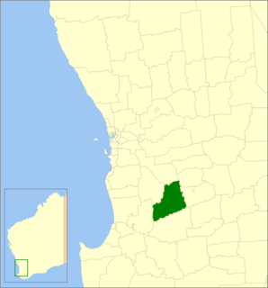
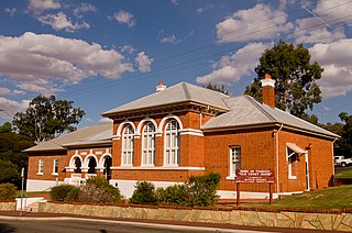
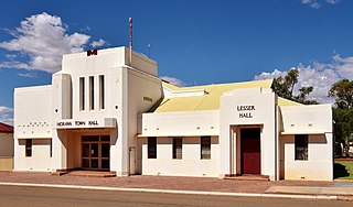
The Shire of Moora is a local government area in the northern Wheatbelt region of Western Australia, and generally lies between the Brand Highway and Great Northern Highway about 180 kilometres (112 mi) north of Perth, the state capital. The Shire covers an area of 3,767 square kilometres (1,454 sq mi) and its seat of government is the town of Moora.

The Shire of Wongan–Ballidu is a local government area in the Wheatbelt region of Western Australia, about 180 kilometres (112 mi) NNE of Perth, the state capital. The Shire covers an area of 3,369 square kilometres (1,301 sq mi) and its seat of government is the town of Wongan Hills.

The Shire of Victoria Plains is a local government area in the Wheatbelt region of Western Australia, about 160 kilometres (100 mi) north of the state capital, Perth. It covers an area of 2,569 square kilometres (992 sq mi), and its seat of government is the town of Calingiri.

The Shire of Kent is a local government area in the Great Southern region of Western Australia, about 320 kilometres (200 mi) southeast of Perth, the state capital. The Shire covers an area of 5,634 square kilometres (2,175 sq mi) and its seat of government is the town of Nyabing. The area produces grains such as wheat, barley and legumes.

The Shire of Wandering is a local government area in the Wheatbelt region of Western Australia, and, with a population of 444 as at the 2016 census, is one of the nation's smallest. It covers an area of 1,901 square kilometres (734 sq mi) generally to the east of Albany Highway about 120 kilometres (75 mi) south-east of Perth, the state capital. The Shire's seat of government is the town of Wandering.

The Shire of Boddington is a local government area in the Peel region of Western Australia, about 120 kilometres (75 mi) south-east of the state capital, Perth. The Shire covers an area of 1,901 square kilometres (734 sq mi), and its seat of government is the town of Boddington.
The Shire of Williams is a local government area in the Wheatbelt region of Western Australia, about 161 kilometres (100 mi) southeast of the state capital, Perth. The Shire covers an area of 2,306 square kilometres (890 sq mi), and its seat of government is the town of Williams.

The City of Kalamunda is a local government area in the eastern metropolitan region of the Western Australian capital city of Perth about 25 kilometres (16 mi) east of Perth's central business district. The area covers 324 square kilometres (125 sq mi), much of which is state forest rising into the Darling Scarp to the east. In the mid 2010s, the area had a population of 57 thousand people.

The Shire of Mundaring is a local government area in eastern metropolitan Perth, the capital of Western Australia. The Shire covers an area of 645 square kilometres (249 sq mi) and had a population of approximately 38,000 as at the 2016 Census.
The Shire of Toodyay is a local government area in the Wheatbelt region of Western Australia, beyond the north-eastern limits of the Perth metropolitan area. The Shire covers an area of 1,694 square kilometres (654 sq mi), and its seat of government is the town of Toodyay.

The Shire of York is a local government area in the Wheatbelt region of Western Australia, covering an area of 2,133 square kilometres (824 sq mi) just beyond the eastern fringe of Perth's metropolitan area. The Shire's seat of government is the town of York.

The Shire of Manjimup is a local government area in the South West region of Western Australia, about 320 kilometres (200 mi) south of the state capital, Perth. The Shire covers an area of 7,027 square kilometres (2,713 sq mi), and its seat of government is the town of Manjimup.

The Shire of Tammin is a local government area in the Wheatbelt region of Western Australia. Its seat of government is the town of Tammin, about 80 kilometres (50 mi) west of Merredin and about 180 kilometres (112 mi) east of Perth, the state capital.

The Shire of Dalwallinu is a local government area in the Wheatbelt region of Western Australia, about 250 kilometres (155 mi) NNE of Perth, the state capital. The Shire covers an area of 7,236 square kilometres (2,794 sq mi) and its seat of government is the town of Dalwallinu.

The Shire of Boyup Brook is a local government area located in the South West region of Western Australia, about 270 kilometres (168 mi) southeast of Perth, the state capital. The Shire covers an area of 2,829 square kilometres (1,092 sq mi) and its seat of government is the town of Boyup Brook.

The Shire of Goomalling is a local government area in the Wheatbelt region of Western Australia, about 240 kilometres (149 mi) northeast of Perth, the state capital. The Shire covers an area of 2,836 square kilometres (1,095 sq mi) and its seat of government is the town of Goomalling.
The Shire of Morawa is a local government area in the Mid West region of Western Australia, about 170 kilometres (106 mi) east-southeast of the city of Geraldton and about 390 kilometres (242 mi) north of the state capital, Perth. The Shire covers an area of 3,516 square kilometres (1,358 sq mi), and its seat of government is the town of Morawa.

The Shire of Perenjori is a local government area in the Mid West region of Western Australia, about 360 kilometres (224 mi) north of the state capital, Perth. The Shire covers an area of 8,313 square kilometres (3,210 sq mi), and its seat of government is the town of Perenjori.

The Shire of Yalgoo is a local government area in the Mid West region of Western Australia, about 500 kilometres (311 mi) north of the state capital, Perth. The Shire covers an area of 28,215 square kilometres (10,894 sq mi), and its seat of government is the town of Yalgoo.


