Related Research Articles

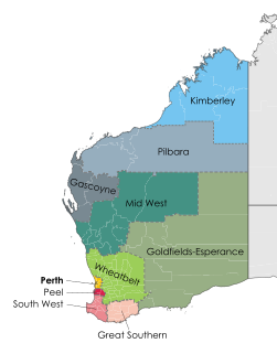
The Pilbara is a large, dry, thinly populated region in the north of Western Australia. It is known for its Aboriginal peoples; its ancient landscapes; the red earth; its vast mineral deposits, in particular iron ore; and as a global biodiversity hotspot for subterranean fauna.

The Shire of Ashburton is one of the four local government areas in the Pilbara region of Western Australia, covering an area of 105,647 square kilometres (40,791 sq mi). It is named after the Ashburton River.
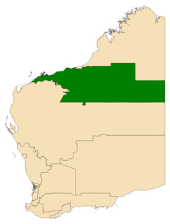
The Electoral district of Pilbara is a Legislative Assembly electorate in the state of Western Australia. Pilbara is named for the region of Western Australia in which it is located. It is one of the oldest electorates in Western Australia, with its first member having been elected to the Second Parliament of the Legislative Assembly at the 1894 elections.

The Shire of East Pilbara is one of the four local government areas in the Pilbara region of Western Australia, and with an area close to 380,000 square kilometres (147,000 sq mi), is the third largest municipality in the world, after two new municipalities in Greenland. The municipality is bigger than many countries, for example Finland and is comparable to Japan. The Shire's seat of government, and home to nearly half the Shire's population, is the town of Newman in the shire's south-west.
Pilbara newspapers is a selection of newspapers published in the Pilbara region of Western Australia.

Yarrie or Yarrie Station is a pastoral lease and cattle station that once operated as a sheep station, located approximately 73 kilometres (45 mi) north east of Marble Bar and 170 kilometres (106 mi) south east of Port Hedland in the Pilbara region of Western Australia. The De Grey River runs through the property.
Muccan or Muccan Station is a pastoral lease and cattle station that once operated as a sheep station, located approximately 68 kilometres (42 mi) north east of Marble Bar and 155 kilometres (96 mi) south east of Port Hedland in the Pilbara region of Western Australia. Kookenyia Creek and the De Grey River run through the property. The country is gently undulating with large areas of spinifex.
James Isdell was an Australian pastoralist and politician who was a member of the Legislative Assembly of Western Australia from 1903 to 1906, representing the seat of Pilbara.
Bonney Downs Station is a pastoral lease that was once a sheep station but now operates as a cattle station in Western Australia.
Callawa Station is a pastoral lease that was once a sheep station but now operates as a cattle station in Western Australia.
Coongan Station is a pastoral lease that was once a sheep station but now operates as a cattle station in Western Australia.
Lalla Rookh Station, often referred to as Lalla Rookh, is a pastoral lease that once operated as a sheep station but now operates as a cattle station.
Mount Edgar Station, often referred to as Mount Edgar, is a pastoral lease that once operated as a sheep station but now operates as a cattle station.
Noreena Downs Station, often referred to as Noreena Downs, is a pastoral lease that has been used as both a sheep station and a cattle station.
Pippingarra Station is a pastoral lease that once operated as a sheep station and now operates as a cattle station, located 25 kilometres (16 mi) south east of Port Hedland and 125 kilometres (78 mi) north west of Marble Bar in the Pilbara region of Western Australia.
The Pilbarra Goldfield News. was a newspaper published from 19 February 1897 to 20 March 1923, first in Marble Bar and then, from 1912, in Port Hedland, and is considered one of the earliest publications from the Pilbara.
The Shire of Tableland was a local government area in Western Australia. It was based in the Hamersley Range and had an office at Tambrey Station until the 1940s, met at Coolawanyah Station in the late 1940s, and met at Wittenoom from the 1950s. It was established as the Tableland Road District on 3 January 1896.
The Shire of Nullagine was a local government area in Western Australia. It was formally established as the Nullagine Road District on 8 July 1898, with part of its territory being severed from the Pilbarra Road District. It was based in the town of Nullagine. However, its practical establishment and the inaugural election of board members was delayed well into 1899 due to local "differences of opinion".
The Ironclad Hotel in Marble Bar in the Pilbara region of Western Australia was built in the 1890s. It was notorious as the only pub in what was considered the hottest town in Australia, having a weather record that was unchallenged in the 1940s to the 1960s, and only surpassed in new mining towns developed after that time.
The Nannine Road District was an early form of local government area on the Western Australian goldfields of the Mid West region.
References
- 1 2 3 4 "Municipality Boundary Amendments Register" (PDF). Western Australian Electoral Distribution Commission. Retrieved 11 January 2020.
- ↑ "BAMBOO CREEK". Northern Public Opinion And Mining And Pastoral News . Western Australia. 13 February 1897. p. 4. Retrieved 16 January 2020– via Trove.
- ↑ "BAMBOO CREEK". Northern Public Opinion And Mining And Pastoral News . Western Australia. 13 February 1897. p. 4. Retrieved 16 January 2020– via Trove.
- ↑ "Advertising". The Pilbarra Goldfield News . Western Australia. 26 November 1897. p. 3. Retrieved 16 January 2020– via Trove.
- ↑ "Advertising". The Pilbarra Goldfield News . Western Australia. 22 January 1909. p. 2. Retrieved 16 January 2020– via Trove.