Barkly Highway

Last updated

Barkly Highway [1]

Queensland
Barkly Highway Queensland.jpg
Barkly Highway in Queensland
General information
TypeHighway
Length754 km (469 mi)
Route number(s)
  • Australian national highway 66.svg National Highway 66 (Tennant Creek – NT/Qld Border; future route B66)
  • AUS Alphanumeric Route A2.svg National Highway A2 (NT/Qld Border – Cloncurry)
  • Australian national route 83.svg National Route 83 (Mount Isa – Cloncurry)
Former
route number
Australian national highway 66.svg National Highway 66 (Entire route)
Australian national highway A2.svg National Highway A2 (NT/Qld Border – Cloncurry)
Major junctions
West endAustralian national highway 87.svg Stuart Highway, Tennant Creek, Northern Territory
 
East endAUS Alphanumeric Route A2.svg Landsborough Highway, Cloncurry, Queensland, duplexed with
AUS Alphanumeric Route A6.svg Flinders Highway
Location(s)
Major settlements Camooweal, Mount Isa
Highway system

The Barkly Highway is a national highway in Queensland and the Northern Territory in Australia. [2] It is the only sealed road between Queensland and the Northern Territory. [3] [4] The Highway is named after Henry Barkly.

Contents

Description

Entering Queensland, 2019 Sign as you enter Queensland on the Barkly Highway from the Northern Territory, 2019 01.jpg
Entering Queensland, 2019

The highway runs between Cloncurry via Mount Isa and Camooweal to the Stuart Highway north of Tennant Creek, at the junction known as the "Threeways". The entire highway is part of the National Highway system: in the Northern Territory it is assigned National Route 66; the Queensland portion is designated as National Route A2.

Entering the Northern Territory, 2019 Sign as you enter the Northern Territory on the Barkly Highway from Queensland, 2019.jpg
Entering the Northern Territory, 2019

The Northern Territory section has a speed limit of 130 kilometres per hour (81 mph) along most of its length. [5]

As the only sealed road linking Queensland and the Northern Territory, it is the main transport route between them, consequently many road trains use it.

Upgrades

An upgrade of the Queensland section of the highway between Mount Isa and Camooweal was completed in 2008 and despite floods of 2009, 2010 and 2011, the Queensland sections of road are in good condition (as of 2015).

The Northern Australia Roads Program announced in 2016 included the following project for the Barkly Highway.

Intersection upgrades

The project for intersection upgrades in Mount Isa urban area was completed in mid 2019 at a total cost of $8.3 million. [6]

Georgina River Bridge

Georgina River Bridge (from Camooweal heading west), 2019 Driving across the Georgina River Bridge from Camooweal looking south at the dry river bed, 2019 03.jpg
Georgina River Bridge (from Camooweal heading west), 2019

Given the economic importance of transport on this route, a longstanding problem was the flooding of the Georgina River immediately west of Camooweal in Queensland. As the water levels in the Georgina River vary enormously from being completely dry to flooding, the Barkly Highway bridge over the Georgina River was often unusable for many days due to flooding, with road trains and other heavy vehicles having to wait weeks before it was safe to cross. To alleviate these problems, the Georgina River Bridge was officially opened on 20 December 2002 by Senator Ron Boswell and Steve Breadhauer, Minister for Transport in the Queensland Government. It replaced the previous bridge which was approximately 50 metres (160 ft) south, and is both higher and longer so traffic on the highway can continue to cross during floods. The bridge is 417 metres (1,368 ft) long and is accompanied by a 5.6-kilometre (3.5 mi) highway deviation west from Camooweal. The bridge uses an unusual curved design to avoid placing pylons into the river bed which is culturally significant to the local Dugalunji people, who call the new bridge Ilaga Thuwani meaning The Camping Ground of the Rainbow Serpent . [4] [7] [8] [9]

Approximate road distances (in kilometres) from Mount Isa westwards Barklyhwy (1).png
Approximate road distances (in kilometres) from Mount Isa westwards

List of towns along the Barkly Highway

Major intersections

StateLGALocationkm [10] miDestinationsNotes
Northern Territory Barkly Warumungu 00.0Australian national highway 87.svg Stuart Highway (National Highway 87) – north  Daly Waters
south  Alice Springs
Barkly Highway western terminus – continues east as National Highway 66
Tablelands 186116Australian state route 11.svg Tablelands Highway (State Route 11) – north  Cape Crawford
Northern Territory – Queensland
state border
433269Northern Territory – Queensland state borderBarkly Highway continues east as National Highway A2
Queensland Georgina River 445277Georgina River Bridge (Ilaga Thuwani Bridge)
Mount Isa Camooweal 446277Camooweal Urandangie Road – south  Urandangi
448278Australian state route 76.svg Gregory Downs Camooweal Road – north–east  Gregory, Burketown
Mount Isa 635395Australian national route 83.svg Boulia Mount Isa Highway (Diamantina Developmental Road) (National Route 83) – south  Dajarra, Boulia Barkly Highway continues east as National Highway A2 duplexed with National Route 83.
Western concurrency terminus with National Route 83.
Leichhardt River 635395 Sir James Foots Bridge
Cloncurry Cloncurry 754469Australian national route 83.svg Burke Developmental Road (National Route 83) – north  Normanton
AUS Alphanumeric Route A6.svg Flinders Highway (Queensland Highway A6), duplexed with
AUS Alphanumeric Route A2.svg Landsborough Highway (National Highway A2)  Cloncurry, Julia Creek, Mckinlay
Eastern end of Barkly Highway. Eastern concurrency terminus with National Route 83.
1.000 mi = 1.609 km; 1.000 km = 0.621 mi

See also

Australia road sign W5-29.svg   Australian Roadsportal

Related Research Articles

<span class="mw-page-title-main">Camooweal Caves National Park</span> Protected area in Queensland, Australia

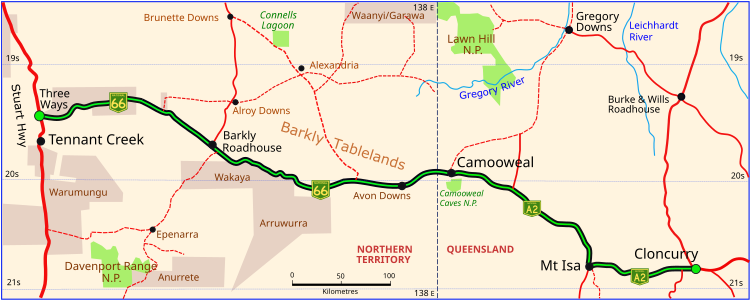
Camooweal Caves is a national park in Queensland, Australia, 15 km southeast of Camooweal and 1720 km northwest of Brisbane.

<span class="mw-page-title-main">Cloncurry, Queensland</span> Town in Queensland, Australia

Cloncurry is a rural town and locality in the Shire of Cloncurry, Queensland, Australia. It is informally known by local people as The Curry. In the 2021 census the locality of Cloncurry had a population of 3,167 people.

<span class="mw-page-title-main">Camooweal</span> Town in Queensland, Australia

Camooweal is an outback town and locality in the City of Mount Isa, Queensland, Australia. The locality is on the Queensland border with the Northern Territory. In the 2021 census, the locality of Camooweal had a population of 236 people.

<span class="mw-page-title-main">Flinders Highway, Queensland</span> Highway in Queensland, Australia

The Flinders Highway is a highway that crosses Queensland east to west, from Townsville on the Pacific coast to Cloncurry. The road continues as the Barkly Highway from Cloncurry to the Northern Territory border at Camooweal and beyond. The Flinders Highway passes a number of small outback towns and typical outback landscape predominates towards the inland. It was known as National Route 78 before Queensland began to convert to the alphanumeric system being adopted in Australia and is now designated as A6. The highway is also known as Overlanders Way. Its entire length is part of the National Land Transport Network.

<span class="mw-page-title-main">Landsborough Highway</span> Highway in Queensland, Australia

Landsborough Highway is a highway in western Queensland, Australia, running in the northwest–southeast direction from Morven to Cloncurry. The Landsborough Highway runs through vast tracts of land that was once occupied by William Landsborough, an Australian explorer of the 19th century. It is also the central part of the tourist route known as the Matilda Way after the popular Australian song Waltzing Matilda, which extends from Bourke in central northern New South Wales to Karumba on the Gulf of Carpentaria.

<span class="mw-page-title-main">Dajarra, Queensland</span> Town in Queensland, Australia

Dajarra is a town and a locality in the Shire of Cloncurry, Queensland, Australia. In the 2016 census, Dajarra had a population of 191 people; 60.3% of the population are Indigenous.

<span class="mw-page-title-main">Kennedy Highway</span> Highway in Queensland, Australia

The Kennedy Highway is a highway in northern Queensland, Australia. It runs as National Route 1 for approximately 243 km from Smithfield, on the northern outskirts of Cairns, to the Gulf Developmental Road in the vicinity of Forty Mile Scrub and Undara Volcanic national parks. South of this junction, the road continues as the Kennedy Developmental Road to Boulia about 936 kilometres away, via Hughenden. West of the junction, National Route 1 continues as the Gulf Developmental Road to Normanton.

<span class="mw-page-title-main">Georgina River</span> River in Queensland, Australia

The Georgina River is the north-westernmost of the three major rivers of the Channel Country in Central West Queensland, that also flows through a portion of the Northern Territory, in central Australia. Part of the Lake Eyre basin, the Georgina flows in extremely wet years into Lake Eyre.

<span class="mw-page-title-main">Sandover Highway</span>

The Sandover Highway is an outback unsealed track in the Northern Territory between the Plenty Highway north of Alice Springs and the Northern Territory/Queensland border.

<span class="mw-page-title-main">Plenty Highway</span>

The Plenty Highway is a 498-kilometre (309 mi) outback mostly unsealed road in the Northern Territory of Australia between the Stuart Highway and north-western Queensland.

Alpurrurulam, from the original Aboriginal name Ilperrelhelame, also known as Lake Nash, is a locality in the Northern Territory of Australia located in the territory's east about 1,206 kilometres (749 mi) south-east of the territory capital of Darwin and about 570.1 kilometres (354.2 mi) east of the municipal seat of Tennant Creek and about 17 kilometres (11 mi) from the border with the state of Queensland. The town is at the end of the Sandover Highway, which floods each year during the wet season and cuts all road access to the community.

<span class="mw-page-title-main">Gulf Developmental Road</span> Highway in Queensland, Australia

Gulf Developmental Road is an Australian highway linking the Cairns and Normanton regions in northern Queensland, Australia. It is the only sealed (asphalt) road linking these two regions.

<span class="mw-page-title-main">Gulf Country</span> Queensland region

The Gulf Country or North West Queensland is the region of woodland and savanna grassland surrounding the Gulf of Carpentaria in north western Queensland and eastern Northern Territory on the north coast of Australia. The region is also called the Gulf Savannah. The Gulf Country is crossed by the Savannah Way highway.

Dajarra and Selwyn Branch Railways were lines in north-west Queensland, Australia. Along with the Mount Cuthbert and Dobbyn Branch Railways, they were essentially built to tap large deposits of copper discovered in the Cloncurry region.

<span class="mw-page-title-main">Great Northern Railway (Mt Isa line)</span>

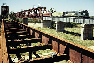
The Great Northern Railway is a 1067 mm gauge railway line in Queensland, Australia. The line stretches nearly 1,000 kilometres linking the port city of Townsville, Australia to the mining town of Mount Isa in north-west Queensland. Along with a passenger service called the Inlander, it is a major freight route connecting the Mount Isa Mines to the Port of Townsville. In 2010, the line moved 5.8 million tonnes of cargo, and this is expected to increase significantly in coming years.

<span class="mw-page-title-main">Tree of Knowledge, Camooweal</span> Historic site in Queensland, Australia

Tree of Knowledge is a heritage-listed tree on the Barkly Highway, Camooweal, City of Mount Isa, Queensland, Australia. It was added to the Queensland Heritage Register on 8 September 2005.

<span class="mw-page-title-main">Community Hall, Camooweal</span> Historic site in Queensland, Australia

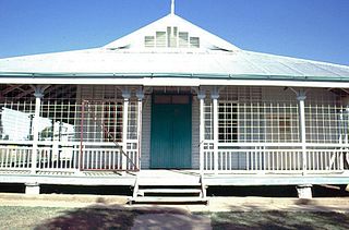
Community Hall is a heritage-listed former town hall at Barkly Highway, Camooweal, City of Mount Isa, Queensland, Australia. It was designed by Rooney Brothers and built from 1922 to 1923 by Hogarth & Hammond. It is also known as Barkly Tablelands Shire Hall. It was added to the Queensland Heritage Register on 21 October 1992.

The Overlanders Way is an Australian road route from Townsville in Queensland to Tennant Creek, Northern Territory. It has been designated by the Queensland Government as a State Strategic Touring Route.

<span class="mw-page-title-main">Barkly, Queensland</span> Suburb of City of Mount Isa, Queensland, Australia

Barkly is an outback locality in the City of Mount Isa, Queensland, Australia. The locality is on the Queensland border with Northern Territory. In the 2016 census Barkly had a population of 28 people.

Cloncurry–Dajarra Road is a continuous 169 kilometres (105 mi) road route in the Cloncurry local government area of Queensland, Australia. It is a state-controlled district road rated as a local road of regional significance (LRRS). It is a north-east to south-west link between the Barkly Highway and the Diamantina Developmental Road, servicing a number of cattle grazing and production areas in northern Queensland.

References

  1. Driver, A.R. (1 May 1947). "THE NORTHERN TERRITORY OF AUSTRALIA, Nomenclature (Public Places) Ordinance 1945". Commonwealth of Australia Gazette . No. 79. Australia. p. 1233. Retrieved 22 May 2019 via National Library of Australia. Barkly Highway.—The main road stretching from the Northern Territory Queensland Border in the vicinity of Camooweal in a westerly direction to join the Stuart Highway at a point about 15 miles north of Tennant Creek.
  2. Hema, Maps (2005). Australia’s Great Desert Tracks NE Sheet (Map). Eight Mile Plains Queensland: Hema Maps. ISBN   978-1865005461.
  3. "Road trip driving routes, car & 4WD | Northern Territory, Australia". Tourism Northern Territory. Archived from the original on 21 December 2020. Retrieved 21 December 2020.
  4. 1 2 Boswell, Ron (9 April 2001). "Expressions of Interest sought for Georgina River Bridge construction". Australian Parliament . Archived from the original on 21 December 2020. Retrieved 21 December 2020.
  5. "Northern Territory Information". Gondwananet.
  6. "Barkly Highway (Cloncurry - Mount Isa) Intersection Upgrades in the Mount Isa Urban Area". Department of Infrastructure, Transport, Regional Development and Communications. 13 September 2021. Retrieved 30 March 2022.
  7. Boswell, Ron (13 June 2002). "Georgina River Bridge underway". Australian Parliament . Archived from the original on 21 December 2020. Retrieved 21 December 2020.
  8. TheBeanTeam (22 August 2012). "Ilaga Thuwani Bridge - 2002 - Camooweal, Queensland, Australia - Bridge Date Stones and Plaques on Waymarking.com". www.waymarking.com. Archived from the original on 21 December 2020. Retrieved 21 December 2020.
  9. Memmott, Paul. "On Generating Culturally Sustainable Enterprises and Demand-Responsive Services in Remote Aboriginal Settings: A case study from north-west Queensland". Indigenous Participation in Australian Economies II. Archived from the original on 21 December 2020. Retrieved 21 December 2020.{{cite book}}: |website= ignored (help)
  10. Google (24 December 2017). "Barkly Highway" (Map). Google Maps . Google. Retrieved 24 December 2017.

Roswitha Soechtig: OVERLAND-BIKING AUSTRALIA auf roter Erde, 2021, ISBN 978–3–7534–1275–7, S. 251–256, German and English.

Commons-logo.svg Media related to Barkly Highway at Wikimedia Commons