
The Bruce Highway is a major highway in Queensland, Australia. Commencing in the state capital, Brisbane, it passes through areas close to the eastern coast on its way to Cairns in Far North Queensland. The route is part of the Australian National Highway and also part of Highway 1, the longest highway route in Australia. Its length is approximately 1,679 kilometres (1,043 mi); it is entirely sealed with bitumen. The highway is named after a popular former Queensland and federal politician, Harry Bruce. Bruce was the state Minister for Works in the mid-1930s when the highway was named after him. The highway once passed through Brisbane, but was truncated at Bald Hills when the Gateway Motorway became National Highway 1 upon its opening in December 1986.

The Capricorn Highway is located in Central Queensland, Australia, and links the city of Rockhampton with western Queensland. The highway is 575 kilometres (357 mi) long, and joins the Landsborough Highway at Barcaldine. Formerly National Route 66, Queensland began to convert to the alphanumeric system much of Australia had adopted in the early-2000s and is now designated as A4. The highway runs parallel with the Tropic of Capricorn, hence its name.

The Flinders Highway is a highway that crosses Queensland east to west, from Townsville on the Pacific coast to Cloncurry. The road continues as the Barkly Highway from Cloncurry to the Northern Territory border at Camooweal and beyond. The Flinders Highway passes a number of small outback towns and typical outback landscape predominates towards the inland. It was known as National Route 78 before Queensland began to convert to the alphanumeric system being adopted in Australia and is now designated as A6. The highway is also known as Overlanders Way. Its entire length is part of the National Land Transport Network.

Carnarvon Highway is a state highway in Queensland and New South Wales, Australia, linking the township of Rolleston in Queensland's Central Highlands Region, via the town of St George, eventually to Moree in northern New South Wales. It is the main access road to the Carnarvon National Park, and serves as a strategic route to take B-doubles and other large vehicles to the Queensland ports north of Rockhampton.

The Moonie Highway is a state highway of Queensland, Australia. Part of State Route 49, it leaves the Warrego Highway at Dalby and runs for over 290 km until it reaches St George. From there, State Route 49 continues west as the Balonne Highway. From Dalby, it continues north-east as the Bunya Highway.

The Dawson Highway is a state highway in Queensland, Australia. It runs for 405 kilometres (252 mi) between Gladstone and Springsure where it terminates. From Gladstone to Rolleston it is signed as State Route 60, and then A7 onwards to Springsure. It continues west for another 247 kilometres (153 mi) as Dawson Developmental Road to Tambo on the Landsborough Highway. North of Springsure, A7 becomes the Gregory Highway.
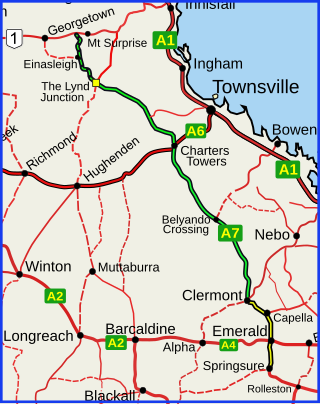
The Gregory Highway is a state highway in Queensland, Australia that serves the major coal-mining centres of Central Queensland. The highway was named after Augustus Gregory, an early explorer.

Landsborough Highway is a highway in western Queensland, Australia, running in the northwest–southeast direction from Morven to Cloncurry. The Landsborough Highway runs through vast tracts of land that was once occupied by William Landsborough, an Australian explorer of the 19th century. It is also the central part of the tourist route known as the Matilda Way after the popular Australian song Waltzing Matilda, which extends from Bourke in central northern New South Wales to Karumba on the Gulf of Carpentaria.

The Gore Highway is a highway running between Toowoomba and Goondiwindi in Queensland, Australia. Together with Goulburn Valley Highway and Newell Highway, it is a part of the National Highway's Melbourne-Brisbane link. It is signed as National Highway A39.

The Arnhem Highway is a 227—kilometre highway in the Northern Territory of Australia. It links the mining town of Jabiru, in Kakadu National Park, to the Stuart Highway at a point 35 kilometres south of Darwin.

The Kennedy Highway is a highway in northern Queensland, Australia. It runs as National Route 1 for approximately 243 km from Smithfield, on the northern outskirts of Cairns, to the Gulf Developmental Road in the vicinity of Forty Mile Scrub and Undara Volcanic national parks. South of this junction, the road continues as the Kennedy Developmental Road to Boulia about 936 kilometres away, via Hughenden. West of the junction, National Route 1 continues as the Gulf Developmental Road to Normanton.
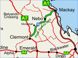
The Peak Downs Highway links the towns of Mackay and Clermont in the Australian state of Queensland. It represents the main link between Queensland's Whitsunday Coast and the Central West region of the state. The highway runs for a total length of 266 kilometres (165 mi), before joining the Gregory Highway south to Clermont, a total of 283 kilometres (176 mi). Major settlements served by this route include Walkerston, Nebo, Moranbah and Clermont.

Gulf Developmental Road is an Australian highway linking the Cairns and Normanton regions in northern Queensland, Australia. It is the only sealed (asphalt) road linking these two regions.

The Tablelands Highway is a 375 kilometre single lane sealed road in the Northern Territory, Australia. It runs from Barkly Homestead on the Barkly Highway to Cape Crawford near Borroloola on the Carpentaria Highway.
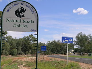
Bollon is a rural town and locality in the Shire of Balonne, Queensland, Australia. In the 2016 census, Bollon had a population of 221 people.

South West Queensland is a remote region in the Australian state of Queensland which covers 319,808 km2 (123,479 sq mi). The region lies to the south of Central West Queensland and west of the Darling Downs and includes the Maranoa district and parts of the Channel Country. The area is noted for its cattle grazing, cotton farming, opal mining and oil and gas deposits.

The Peninsula Developmental Road (PDR) runs 571 km (355 mi) from Lakeland to Weipa. It is the main road transport link within Cape York Peninsula and to the rest of the Australian mainland.
The Diamantina Developmental Road is a gazetted road in Queensland, Australia, that runs from Charleville in the south-central part of the state to Mount Isa in the north-west.
The Great Inland Way is an Australian road route from Sydney, New South Wales to Cairns in Queensland. It has been designated by the Queensland Government as a State Strategic Touring Route.
Roads of Strategic Importance in Queensland is a list of roads in Queensland, Australia, that are the subject of one or more road improvement projects under the Roads of Strategic Importance (ROSI) initiative of the Australian Government. The purposes of this document are to:
