Diamantina Developmental Road

Last updated

Diamantina Developmental Road

Diamantina Developmental Road, Charleville - Quilpie (1979).jpg
Diamantina Developmental Road, Charleville to Quilpie, 1979
Diamantina Developmental Road - Map.svg
General information
TypeRural road
Length1,344 km (835 mi)
Route number(s)
  • Australian state route 14.svg State Route 14 (Charleville – Windorah)
  • Australian state route 12.svg State Route 12 (Windorah – Bedourie)
  • Australian national route 83.svg National Route 83 (Bedourie – Mount Isa)
Major junctions
South-east endAUS Alphanumeric Route A71.svg Mitchell Highway (State Highway A71), Charleville, Queensland
 
North-west endAustralian national route 83.svgAUS Alphanumeric Route A2.svg Barkly Highway (National Route 83 / State Route A2), Mount Isa, Queensland
Location(s)
Major settlements Quilpie, Windorah, Bedourie, Boulia, Dajarra

The Diamantina Developmental Road is a gazetted road in Queensland, Australia, that runs from Charleville in the south-central part of the state to Mount Isa in the north-west. [1]

Contents

Route description

Near Quilpie, 2012 Road to Quilpie - Development Road.JPG
Near Quilpie, 2012
Near Mount Isa, 2016 Diamantina Developmental Road, 2016.jpg
Near Mount Isa, 2016

The road passes through the towns of Quilpie, Windorah, Bedourie, Boulia, and Dajarra in its 1344 kilometer length, and most of it is sealed. [2] Some sections between Windorah and Boulia are unsealed. The section from Boulia to Mount Isa is also known as the Boulia Mount Isa Highway and the section from Bedourie to Boulia is also known as the Boulia Bedourie Road. The section from the Eromanga boundary to the Windorah CBD is also known as the Quilpie Windorah Road.

The road crosses several well known rivers and creeks of the Channel Country of south-west Queensland, including the Paroo River, Bulloo River, Cooper Creek and Diamantina River.

Responsible authority

Maintenance of the road is the responsibility of the Queensland Government. [1]

Northern Australia Beef Roads upgrade

The Northern Australia Beef Roads Program announced in 2016 included the following project for the Diamantina Developmental Road.

Rehabilitation and widening

The project to rehabilitate and widen the road from Boulia to Dajarra was completed in mid 2019 at a total cost of $5 million. [3]

Other upgrades

Widen narrow seal

A project to widen the narrow seal on almost 3 kilometres (2 mi) of road immediately south of Boulia, at a cost of $2.145 million, was completed in June 2021. [4]

Reconstruct and widen

A project to reconstruct and widen 2 kilometres (1.2 mi) of road immediately north of Boulia, at a cost of $1.025 million, was completed in April 2021. [5]

Widen and seal

A project to widen and seal two sections of road west of Charleville, at a cost of $6.65 million, was completed in March 2022. [6]

Floodway upgrade

A project to upgrade the Top Limestone Creek floodway, at a cost of $1.5 million, was completed in September 2020. [7]

Major intersections

LGALocationkmmiDestinationsNotes
Murweh Charleville 00.0AUS Alphanumeric Route A71.svg Mitchell Highway (State Highway A71) – north – Augathella /
south – Cunnamulla
South-eastern end of Diamantina Developmental Road (State Route 14)
Quilpie Quilpie 197122Quilpie Adavale Road – north – Adavale
212132Quilpie Thargomindah Road – south – Thargomindah
247153 Cooper Developmental Road – west – Eromanga
Quilpie / Barcoo boundary Eromanga / Windorah boundary385239Name changes to Quilpie Windorah Road
Barcoo Windorah 450280Australian national route 79.svg Thomson Developmental Road (See Notes column) – north – Longreach Thomson Developmental Road is part of a former proposed National Route 79 from Melbourne to Longreach. This route is now signed as M79/A79 from Melbourne to Mildura, then B79 to Broken Hill, beyond which there is no signed number. [8]
456283Name reverts to Diamantina Developmental Road as it passes through Windorah CBD
566352Australian state route 14.svg Birdsville Developmental Road (State Route 14) – south–west – Birdsville Road changes to State Route 12
Diamantina Bedourie 824512Australian national route 83.svg Eyre Developmental Road (National Route 83) – south – BirdsvilleRoad changes to National Route 83
847526Name changes to Boulia Bedourie Road as it passes through Bedourie CBD
Boulia Boulia 1,038645Australian state route 62.svg Winton Road (State Route 62) – east – Winton Name changes to Boulia Mount Isa Highway
1,048651 Donohue Highway – west – Queensland / Northern Territory border, where it becomes Plenty Highway (NT State Route 12)
Mount Isa Mount Isa 1,344835AUS Alphanumeric Route A2.svg Barkly Highway (State Highway A2) – north, then west – Camooweal /
Australian national route 83.svg Barkly Highway (National Highway 83) – east – Cloncurry
North–western end of Diamantina Developmental Road
1.000 mi = 1.609 km; 1.000 km = 0.621 mi
  •        Route transition

Related Research Articles

<span class="mw-page-title-main">Capricorn Highway</span> Highway in Queensland, Australia

The Capricorn Highway is located in Central Queensland, Australia, and links the city of Rockhampton with western Queensland. The highway is 575 kilometres (357 mi) long, and joins the Landsborough Highway at Barcaldine. Formerly National Route 66, Queensland began to convert to the alphanumeric system much of Australia had adopted in the early-2000s and is now designated as A4. The highway runs parallel with the Tropic of Capricorn, hence its name.

<span class="mw-page-title-main">Flinders Highway, Queensland</span> Highway in Queensland, Australia

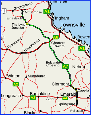
The Flinders Highway is a highway that crosses Queensland east to west, from Townsville on the Pacific coast to Cloncurry. The road continues as the Barkly Highway from Cloncurry to the Northern Territory border at Camooweal and beyond. The Flinders Highway passes a number of small outback towns and typical outback landscape predominates towards the inland. It was known as National Route 78 before Queensland began to convert to the alphanumeric system being adopted in Australia and is now designated as A6. The highway is also known as Overlanders Way. Its entire length is part of the National Land Transport Network.

<span class="mw-page-title-main">Dawson Highway</span>

The Dawson Highway is a state highway in Queensland, Australia. It runs for 405 kilometres (252 mi) between Gladstone and Springsure where it terminates. From Gladstone to Rolleston it is signed as State Route 60, and then A7 onwards to Springsure. It continues west for another 247 kilometres (153 mi) as Dawson Developmental Road to Tambo on the Landsborough Highway. North of Springsure, A7 becomes the Gregory Highway.

<span class="mw-page-title-main">Gregory Highway</span> State highway in Queensland, Australia

The Gregory Highway is a state highway in Queensland, Australia that serves the major coal-mining centres of Central Queensland. The highway was named after Augustus Gregory, an early explorer.

<span class="mw-page-title-main">Landsborough Highway</span> Highway in Queensland, Australia

Landsborough Highway is a highway in western Queensland, Australia, running in the northwest–southeast direction from Morven to Cloncurry. The Landsborough Highway runs through vast tracts of land that was once occupied by William Landsborough, an Australian explorer of the 19th century. It is also the central part of the tourist route known as the Matilda Way after the popular Australian song Waltzing Matilda, which extends from Bourke in central northern New South Wales to Karumba on the Gulf of Carpentaria.

<span class="mw-page-title-main">Dajarra, Queensland</span> Town in Queensland, Australia

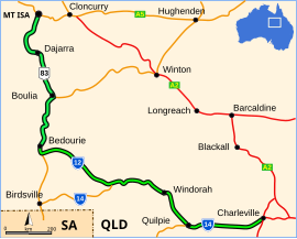
Dajarra is a town and a locality in the Shire of Cloncurry, Queensland, Australia. In the 2016 census, Dajarra had a population of 191 people; 60.3% of the population are Indigenous.

<span class="mw-page-title-main">Kennedy Highway</span> Highway in Queensland, Australia

The Kennedy Highway is a highway in northern Queensland, Australia. It runs as National Route 1 for approximately 243 km from Smithfield, on the northern outskirts of Cairns, to the Gulf Developmental Road in the vicinity of Forty Mile Scrub and Undara Volcanic national parks. South of this junction, the road continues as the Kennedy Developmental Road to Boulia about 936 kilometres away, via Hughenden. West of the junction, National Route 1 continues as the Gulf Developmental Road to Normanton.

<span class="mw-page-title-main">Plenty Highway</span>

The Plenty Highway is a 498-kilometre (309 mi) outback mostly unsealed road in the Northern Territory of Australia between the Stuart Highway and north-western Queensland.

<span class="mw-page-title-main">Gulf Developmental Road</span> Highway in Queensland, Australia

Gulf Developmental Road is an Australian highway linking the Cairns and Normanton regions in northern Queensland, Australia. It is the only sealed (asphalt) road linking these two regions.

<span class="mw-page-title-main">Burke Developmental Road</span> Road in Queensland, Australia

The Burke Developmental Road is a Queensland (Australia) developmental road. It links Cloncurry and Normanton in a south–north direction, then turns to the north-east 30 km (19 mi) north of Normanton for 230 km (140 mi) before turning south-east till Dimbulah, where it becomes the Mareeba Dimbulah Road.

<span class="mw-page-title-main">Donohue Highway</span> Track in Queensland and the Northern Territory

The Donohue Highway is a 249 km (155 mi) mostly unpaved outback track that leads through the northern foothills of the Simpson Desert in Queensland to Tobermorey Homestead, Northern Territory near the Northern Territory/Queensland border in Australia.

<span class="mw-page-title-main">Central West Queensland</span> Region in Queensland, Australia

Central West Queensland is a remote region in the Australian state of Queensland which covers 396,650.2 km2. The region lies to the north of South West Queensland and south of the Gulf Country. It has a population of approximately 12,387 people.

The Great Western Railway was a railway development proposal involving a total of five new lines in western Queensland, Australia. Construction started in 1911 on sections of four of the lines, and three were opened in part before the project was effectively abandoned in 1920.

<span class="mw-page-title-main">Bowen Developmental Road</span>

Bowen Developmental Road is a rural strategic main road in Queensland, Australia. It is part of State Route 77, and functions as a highway. It has a length of 259 kilometres (161 mi) and extends in northeast-southwest direction from Bowen on the east coast of Australia to the Gregory Developmental Road in Belyando near Nairana National Park.

<span class="mw-page-title-main">Eyre Developmental Road</span>

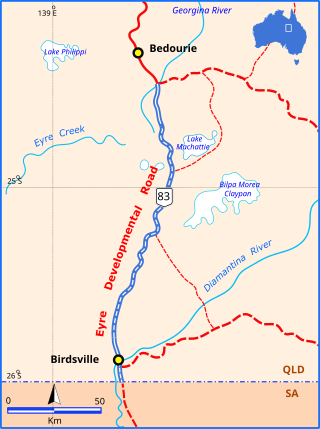
The Eyre Developmental Road is a gazetted road in south-west Queensland that runs from Bedourie to Birdsville and then to the border with South Australia, where it continues as the Birdsville Track. At the northern end it joins the Diamantina Developmental Road, and the mostly unsealed road crosses the Georgina River and Diamantina River. Maintenance of the road is the responsibility of the Queensland State Government. The road intersects with the Birdsville Developmental Road in Birdsville.

<span class="mw-page-title-main">Fitzroy Developmental Road</span>

The Fitzroy Developmental Road is a designated road in the Central Highlands Region of Queensland consisting of three separate sections. The general direction is from south to north.

<span class="mw-page-title-main">Birdsville Developmental Road</span> Road in Australia

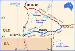
The Birdsville Developmental Road is a mostly unsealed road in south-west Queensland that branches off the Diamantina Developmental Road at a point 103 kilometres (64 mi) west of Windorah and runs to Birdsville. Its length is 273 kilometres (170 mi). The road crosses a major channel of the Diamantina River just before reaching Birdsville. It links with Cordillo Downs road and Arrabury Road, both of which lead to the South Australian town of Innamincka.

<span class="mw-page-title-main">Amaroo, Queensland</span> Suburb of Shire of Boulia, Queensland, Australia

Amaroo is an outback locality split between the Shire of Boulia and the Shire of Diamantina, both in Central Western Queensland, Australia. In the 2016 census, Amaroo had a population of 22 people.

Farrars Creek is a rural locality in the Shire of Barcoo, Queensland, Australia. In the 2016 census, Farrars Creek had a population of 2 people.

Cloncurry–Dajarra Road is a continuous 169 kilometres (105 mi) road route in the Cloncurry local government area of Queensland, Australia. It is a state-controlled district road rated as a local road of regional significance (LRRS). It is a north-east to south-west link between the Barkly Highway and the Diamantina Developmental Road, servicing a number of cattle grazing and production areas in northern Queensland.

References

  1. 1 2 "Queensland Government - Department of Transport and Main Roads - Maps". Archived from the original on 19 March 2018. Retrieved 13 April 2014.
  2. Hema, Maps (2007). Australia Road and 4WD Atlas (Map). Eight Mile Plains Queensland: Hema Maps. pp. 16, 17, 18, 19. ISBN   978-1-86500-456-3.
  3. "Diamantina Developmental Road - (Boulia - Dajarra) - Rehabilitation and Widening". Department of Infrastructure, Transport, Regional Development and Communications. 18 June 2019. Archived from the original on 16 March 2022. Retrieved 30 March 2022.
  4. "Diamantina Developmental Road (Bedourie – Boulia), widen narrow seal". Queensland Government. 22 November 2021. Archived from the original on 6 July 2022. Retrieved 10 June 2022.
  5. "Diamantina Developmental Road (Boulia – Dajarra) Outback Way, reconstruct and widen". Queensland Government. 22 November 2021. Archived from the original on 10 June 2022. Retrieved 10 June 2022.
  6. "Diamantina Developmental Road (Charleville - Quilpie), widen and seal". Queensland Government. 24 May 2022. Archived from the original on 10 June 2022. Retrieved 10 June 2022.
  7. "Top Limestone Creek floodway upgrade". Queensland Government. 22 November 2021. Archived from the original on 5 July 2022. Retrieved 5 July 2022.
  8. "National Route 79". ozroads.com.au. Archived from the original on 18 February 2017. Retrieved 10 January 2017.

Commons-logo.svg Media related to Diamantina Developmental Road at Wikimedia Commons