Northern Australia Beef Roads Program is a suite of projects designed to deliver targeted upgrades to key roads for transporting cattle in northern Australia. In 2016 the Australian Government announced 18 projects to be funded under this program. This program is separate to the Northern Australia Roads Program, also announced in 2016, which contains a further 20 projects. [1]
Funding by the Australian Government is up to 80% of total costs, with the remainder being met by state, territory and local governments. The initial funding allocation by the Australian Government was $100 million, most of which has now (in April 2022) been expended on the identified projects, most of which have been completed or are nearing completion. [1]
The work undertaken includes road widening, sealing and pavement renewal. [1]
The roads involved in the 18 projects are listed below. [1]
Project details have been included in each wikipedia article.
The Northern Australia Beef Roads Program is part of the White Paper on Developing Northern Australia , a $600 million commitment to upgrade high priority roads in northern Australia. [2]
The Parliament of Australia has produced a report on transport infrastructure that includes extensive details of the Northern Australia Beef Roads Program, among others. [3]

The Bruce Highway is a major highway in Queensland, Australia. Commencing in the state capital, Brisbane, it passes through areas close to the eastern coast on its way to Cairns in Far North Queensland. The route is part of the Australian National Highway and also part of Highway 1, the longest highway route in Australia. Its length is approximately 1,679 kilometres (1,043 mi); it is entirely sealed with bitumen. The highway is named after a popular former Queensland and federal politician, Harry Bruce. Bruce was the state Minister for Works in the mid-1930s when the highway was named after him. The highway once passed through Brisbane, but was truncated at Bald Hills when the Gateway Motorway became National Highway 1 upon its opening in December 1986.
New England Highway is an 883-kilometre (549 mi) long highway in Australia running from Yarraman, north of Toowoomba, Queensland, at its northern end to Hexham at Newcastle, New South Wales, at its southern end. It is part of Australia's National Highway system, and forms part of the inland route between Brisbane and Sydney.

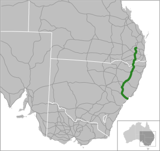
The Capricorn Highway is located in Central Queensland, Australia, and links the city of Rockhampton with western Queensland. The highway is 575 kilometres (357 mi) long, and joins the Landsborough Highway at Barcaldine. Formerly National Route 66, Queensland began to convert to the alphanumeric system much of Australia had adopted in the early-2000s and is now designated as A4. The highway runs parallel with the Tropic of Capricorn, hence its name.

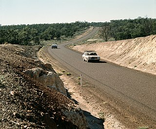
The Flinders Highway is a highway that crosses Queensland east to west, from Townsville on the Pacific coast to Cloncurry. The road continues as the Barkly Highway from Cloncurry to the Northern Territory border at Camooweal and beyond. The Flinders Highway passes a number of small outback towns and typical outback landscape predominates towards the inland. It was known as National Route 78 before Queensland began to convert to the alphanumeric system being adopted in Australia and is now designated as A6. The highway is also known as Overlanders Way. Its entire length is part of the National Land Transport Network.

Carnarvon Highway is a state highway in Queensland and New South Wales, Australia, linking the township of Rolleston in Queensland's Central Highlands Region, via the town of St George, eventually to Moree in northern New South Wales. It is the main access road to the Carnarvon National Park, and serves as a strategic route to take B-doubles and other large vehicles to the Queensland ports north of Rockhampton.
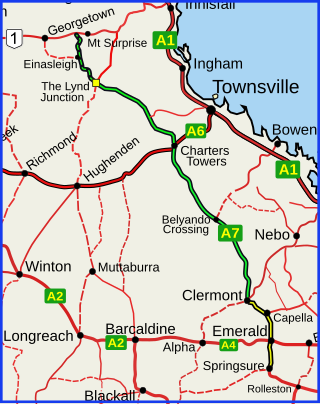
The Gregory Highway is a state highway in Queensland, Australia that serves the major coal-mining centres of Central Queensland. The highway was named after Augustus Gregory, an early explorer.

Landsborough Highway is a highway in western Queensland, Australia, running in the northwest–southeast direction from Morven to Cloncurry. The Landsborough Highway runs through vast tracts of land that was once occupied by William Landsborough, an Australian explorer of the 19th century. It is also the central part of the tourist route known as the Matilda Way after the popular Australian song Waltzing Matilda, which extends from Bourke in central northern New South Wales to Karumba on the Gulf of Carpentaria.

The Kennedy Highway is a highway in northern Queensland, Australia. It runs as National Route 1 for approximately 243 km from Smithfield, on the northern outskirts of Cairns, to the Gulf Developmental Road in the vicinity of Forty Mile Scrub and Undara Volcanic national parks. South of this junction, the road continues as the Kennedy Developmental Road to Boulia about 936 kilometres away, via Hughenden. West of the junction, National Route 1 continues as the Gulf Developmental Road to Normanton.

The Burke Developmental Road is a Queensland (Australia) developmental road. It links Cloncurry and Normanton in a south–north direction, then turns to the north-east 30 km (19 mi) north of Normanton for 230 km (140 mi) before turning south-east till Dimbulah, where it becomes the Mareeba Dimbulah Road.

The Peninsula Developmental Road (PDR) runs 571 km (355 mi) from Lakeland to Weipa. It is the main road transport link within Cape York Peninsula and to the rest of the Australian mainland.
The Diamantina Developmental Road is a gazetted road in Queensland, Australia, that runs from Charleville in the south-central part of the state to Mount Isa in the north-west.
Rockhampton–Emu Park Road is a continuous 44.1 kilometres (27.4 mi) road route in the Rockhampton and Livingstone local government areas of Queensland, Australia. The route is designated as State Route 4 (Regional) and Tourist Drive 10. It is a state-controlled regional road.
Northern Australia Roads Program is a suite of projects designed to deliver upgrades to high priority roads in northern Australia. In 2016 the Australian Government announced 19 projects to be funded under this program, and in 2020 another was added. This program is separate to the Northern Australia Beef Roads Program, also announced in 2016, which contains a further 18 projects.
Richmond–Croydon Road is a continuous 360 kilometres (220 mi) road route in the Richmond, Croydon and Etheridge local government areas of Queensland, Australia. It is part of the shortest route from the Croydon / Georgetown area to Winton and Longreach. It is also part of the inland freight network linking cattle properties to major freight routes on the Landsborough and Flinders highways.
Richmond–Winton Road is a continuous 145 kilometres (90 mi) road route in the Richmond and Winton local government areas of Queensland, Australia. It is a state-controlled district road rated as a local road of regional significance (LRRS). It is part of the shortest route from the Croydon / Georgetown area to Winton and Longreach. It is also part of the inland freight network linking cattle properties to major freight routes on the Landsborough and Flinders highways.
Ootann Road is a continuous 90.5 kilometres (56.2 mi) road route in the Mareeba and Tablelands local government areas of Queensland, Australia. It is a north-south link between the Burke Developmental Road and the Kennedy Highway, servicing a number of cattle grazing and production areas in northern Queensland. It is also part of the shortest route from the Chillagoe area to Hughenden.
Rockhampton–Yeppoon Road is a non-continuous 39.8 kilometres (24.7 mi) road route in the Rockhampton and Livingstone local government areas of Queensland, Australia. Most of the route is designated as State Route 4 (Regional) and Tourist Drive 10. It is a state-controlled regional road.
Roads of Strategic Importance (ROSI) is a $5.8 billion initiative of the Australian Government designed to help connect regional businesses to local and international markets, and to better connect regional communities. The source for this article is an Australian Government website titled "Roads of Strategic Importance". Funding by the Australian Government is up to 80% of total costs, with the remainder being met by state, territory and local governments. ROSI reserves $1.5 billion for projects in Northern Australia, building on the benefits being delivered by the Northern Australia Roads Program and the Northern Australia Beef Roads Program.
Roads of Strategic Importance in Queensland is a list of roads in Queensland, Australia, that are the subject of one or more road improvement projects under the Roads of Strategic Importance (ROSI) initiative of the Australian Government. The purposes of this document are to:
Rockhampton Ring Road is a 14.7 kilometres (9.1 mi) proposed highway from Fairy Bower on the Capricorn Highway south-west of Rockhampton to Parkhurst on the Bruce Highway to the north-east of Rockhampton, in Queensland, Australia. The road will be two lanes from the Capricorn Highway to a connection in Pink Lily and four lanes from there to the Bruce Highway, including a new bridge over the Fitzroy River. It will enable through traffic to bypass the Rockhampton CBD, avoiding 19 sets of traffic signals, and will eliminate delays caused by flooding on sections of the Bruce Highway within the city.