The Capricorn Highway is located in Central Queensland, Australia, and links the city of Rockhampton with western Queensland. The highway is 575 kilometres (357 mi) long, and joins the Landsborough Highway at Barcaldine. Formerly National Route 66, Queensland began to convert to the alphanumeric system much of Australia had adopted in the early-2000s and is now designated as A4. The highway runs parallel with the Tropic of Capricorn, hence its name.

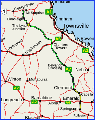
The Flinders Highway is a highway that crosses Queensland east to west, from Townsville on the Pacific coast to Cloncurry. The road continues as the Barkly Highway from Cloncurry to the Northern Territory border at Camooweal and beyond. The Flinders Highway passes a number of small outback towns and typical outback landscape predominates towards the inland. It was known as National Route 78 before Queensland began to convert to the alphanumeric system being adopted in Australia and is now designated as A6. The highway is also known as Overlanders Way. Its entire length is part of the National Land Transport Network.
The Gregory Highway is a state highway in Queensland, Australia that serves the major coal-mining centres of Central Queensland. The highway was named after Augustus Gregory, an early explorer.

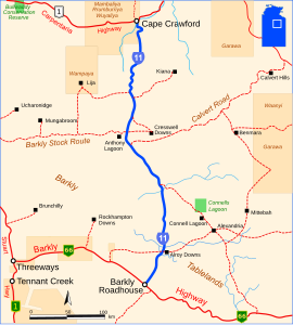
The Barkly Highway is a national highway of both Queensland and the Northern Territory in Australia. It is the only sealed road between Queensland and the Northern Territory.

Landsborough Highway is a highway in western Queensland, Australia, running in the northwest–southeast direction from Morven to Cloncurry. The Landsborough Highway runs through vast tracts of land that was once occupied by William Landsborough, an Australian explorer of the 19th century. It is also the central part of the tourist route known as the Matilda Way after the popular Australian song Waltzing Matilda, which extends from Bourke in central northern New South Wales to Karumba on the Gulf of Carpentaria.
Port Wakefield Highway is an important South Australian highway, connecting Adelaide to the Yorke Peninsula, Port Augusta, northern and western South Australia, the Northern Territory and Western Australia. It is designated National Highway A1 and a part of the National Highway. It is named after Port Wakefield, the first government town north of Adelaide.

Lasseter Highway is a fully sealed 244 kilometre highway in the Northern Territory of Australia. It connects Yulara, Kata Tjuta and Uluru east to the Stuart Highway at Erldunda. The highway is named after Lewis Hubert Lasseter, who claimed to have discovered a fabulously rich gold reef west of Kata Tjuta.

The Captain Cook Highway is a short, regional highway in Queensland which originates in Cairns and terminates in Mossman, where it joins Mossman-Daintree Road, continuing to Daintree. It is a state-controlled regional road.

The Arnhem Highway is a 227—kilometre highway in the Northern Territory of Australia. It links the mining town of Jabiru, in Kakadu National Park, to the Stuart Highway at a point 35 kilometres south of Darwin.

The Kennedy Highway is a highway in northern Queensland, Australia. It runs as National Route 1 for approximately 243 km from Smithfield, on the northern outskirts of Cairns, to the Gulf Developmental Road in the vicinity of Forty Mile Scrub and Undara Volcanic national parks. South of this junction, the road continues as the Kennedy Developmental Road to Boulia about 936 kilometres away, via Hughenden. West of the junction, National Route 1 continues as the Gulf Developmental Road to Normanton.
The Plenty Highway is a 498-kilometre (309 mi) outback mostly unsealed road in the Northern Territory of Australia between the Stuart Highway and north-western Queensland.

Gulf Developmental Road is an Australian highway linking the Cairns and Normanton regions in northern Queensland, Australia. It is the only sealed (asphalt) road linking these two regions.

The Buntine Highway is a 581-kilometre highway in the Northern Territory and Western Australia. It runs from the Victoria Highway via Top Springs and Kalkarindji and then to Nicholson, Western Australia. The section from the Victoria Highway to Kalkaringi is a single-lane sealed road with a few dual-lane sections; the remaining section is unsealed. Funding for maintenance is provided by the Northern Territory government.

The Carpentaria Highway is a 380-kilometre-long (240 mi) highway, which runs from near Daly Waters to Borroloola in the Northern Territory, Australia. It is a sealed road and is part of National Highway 1. The Highway takes its name from the Gulf of Carpentaria, which it links with the Stuart Highway. The Carpentaria Highway also provides road access to the McArthur River mineral deposits and port facilities at Bing Bong, as well as the isolated community of Borroloola and the popular fishing location at King Ash Bay. Funding for maintenance is provided by the Northern Territory government.
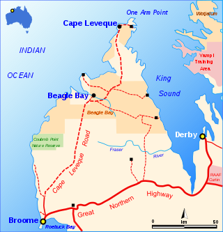
The Cape Leveque Road is a regional Western Australian road that runs through pindan woodland for 205 kilometres (127 mi) between Broome and Cape Leveque on the Dampier Peninsula.
Barkly Homestead is a roadhouse in the Northern Territory of Australia located on the Barkly Tableland. It is located near the intersection of the Barkly Highway and the Tablelands Highway between the Queensland Border town of Camooweal and the Northern Territory town of Tennant Creek. The roadhouse provides, fuel, meals, snacks, camping, motel, cabin, and powered caravan sites to travellers. It is the only stop between the Stuart Highway and the border of Queensland.

The Donohue Highway is a 249 km (155 mi) mostly unpaved outback track that leads through the northern foothills of the Simpson Desert in Queensland to Tobermorey Homestead, Northern Territory near the Northern Territory/Queensland border in Australia.
The Diamantina Developmental Road is a gazetted road in Queensland, Australia, that runs from Charleville in the south-central part of the state to Mount Isa in the north-west.
Barkly Stock Route is a designated state route in the Northern Territory of Australia. Forming part of State Route 16, it connects the Stuart Highway near Elliott with the Tablelands Highway and Cresswell Road.