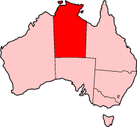
The Northern Territory is an Australian territory in the central and central northern regions of Australia. The Northern Territory shares its borders with Western Australia to the west, South Australia to the south, and Queensland to the east. To the north, the territory looks out to the Timor Sea, the Arafura Sea and the Gulf of Carpentaria, including Western New Guinea and other islands of the Indonesian archipelago.

Kakadu National Park is a protected area in the Northern Territory of Australia, 171 km (106 mi) southeast of Darwin. It is a World Heritage Site. Kakadu is also gazetted as a locality, covering the same area as the national park, with 313 people recorded living there in the 2016 Australian census.

Humpty Doo is a town in Australia's Northern Territory, situated just south of the Arnhem Highway, approximately 40 km from Darwin. At the 2016 census, Humpty Doo had a population of 4,313 people. Its local government area is Litchfield Municipality. The town is a popular stopping point for tourists travelling between Darwin and Kakadu National Park, and boasts many attractions of its own. The main industries are agriculture and tourism; however, most residents commute to Darwin or Palmerston for work, and many regard it as a dormitory town.

Highways in Australia are generally high capacity roads managed by state and territory government agencies, though Australia's federal government contributes funding for important links between capital cities and major regional centres. Prior to European settlement, the earliest needs for trade and travel were met by narrow bush tracks, used by tribes of Indigenous Australians. The formal construction of roads began in 1788, after the founding of the colony of New South Wales, and a network of three major roads across the colony emerged by the 1820s. Similar road networks were established in the other colonies of Australia. Road construction programs in the early 19th century were generally underfunded, as they were dependent on government budgets, loans, and tolls; while there was a huge increase in road usage, due to the Australian gold rushes. Local government authorities, often known as Road Boards, were therefore established to be primarily responsible for funding and undertaking road construction and maintenance. The early 1900s saw both the increasingly widespread use of motorised transportation, and the creation of state road authorities in each state, between 1913 and 1926. These authorities managed each state's road network, with the main arterial roads controlled and maintained by the state, and other roads remaining the responsibility of local governments. The federal government became involved in road funding in the 1920s, distributing funding to the states. The depression of the 1930s slowed the funding and development of the major road network until the onset on World War II. Supply roads leading to the north of the country were considered vital, resulting in the construction of Barkly, Stuart, and Eyre Highways.

The Top End of Australia's Northern Territory is a geographical region encompassing the northernmost section of the Northern Territory, which aside from the Cape York Peninsula is the northernmost part of the Australian continent. It covers a rather vaguely defined area of about 245,000 km² behind the northern coast from the Northern Territory capital of Darwin across to Arnhem Land with the Indian Ocean on the west, the Arafura Sea to the north, and the Gulf of Carpentaria to the east, and with the almost waterless semi-arid interior of Australia to the south, beyond the huge Kakadu National Park.

Katherine is a town in the Northern Territory of Australia. It is situated on the Katherine River, after which it is named, 320 kilometres (200 mi) southeast of Darwin. The fourth largest settlement in the Territory, it is known as the place where "The outback meets the tropics". Katherine had an urban population of approximately 6,300 at the 2016 Census.

Stuart Highway is a major Australian highway. It runs from Darwin, in the Northern Territory, via Tennant Creek and Alice Springs, to Port Augusta in South Australia; a distance of 2,720 km (1,690 mi). Its northern and southern extremities are segments of Australia's Highway 1. The principal north–south route through the central interior of mainland Australia, the highway is often referred to simply as "The Track".

The Barkly Highway is a national highway in Queensland and the Northern Territory in Australia. It is the only sealed road between Queensland and the Northern Territory.

The Victoria Highway links the Great Northern Highway in Western Australia with the Stuart Highway in the Northern Territory. The highway is a part of the Perth–Darwin National Highway link. It is signed as National Highway 1, and is part of Highway 1, a circular route around the country. It is 555 kilometres (345 mi) long, and most of the route – some 470 kilometres (290 mi) – lies within the Northern Territory. In some areas it runs in parallel with the Northern Territory's Victoria River, from which its name originates.

The Arnhem Highway is a 227—kilometre highway in the Northern Territory of Australia. It links the mining town of Jabiru, in Kakadu National Park, to the Stuart Highway at a point 35 kilometres south of Darwin.

Gunbalanya is an Aboriginal Australian town in west Arnhem Land in the Northern Territory of Australia, about 300 kilometres (190 mi) east of Darwin. The main language spoken in the community is Kunwinjku. At the 2021 Australian census, Gunbalanya had a population of 1,177.
The Kakadu Highway is 209 kilometres long and extends from Pine Creek to Jabiru, entering Kakadu National Park as the highway crosses the Mary River. The highway is signed and mapped as State Route 21.

The Jim Jim Falls is a plunge waterfall on the Jim Jim Creek that descends over the Arnhem Land escarpment within the UNESCO World Heritage–listed Kakadu National Park in the Northern Territory of Australia. The Jim Jim Falls area is registered on the Australian National Heritage List.
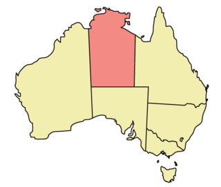
The Northern Territory (NT) occupies the north central part of the continent of Australia. The Northern Territory borders are to the west with Western Australia, the Western Australia border being near the 129° east longitude. The NT to the south with the South Australian border being the 26th parallel south latitude. To the east the NT with the Queensland border along the 138° east longitude.

The Cox Peninsula Road is a rural road in the Northern Territory of Australia linking the Cox Peninsula and western shore of Darwin Harbour to the Stuart Highway in the rural suburb of Noonamah on the outskirts of Darwin. The route is approximately 80 km (50 mi) and passes through the town of Berry Springs as well as the rural areas of Tumbling Waters and Blackmore heading west, before turning north towards the Indigenous community of Belyuen. The road ends at a junction with Charles Point Road in Wagait Shire, a few kilometres west of Mandorah on the Cox Peninsula.
Dorat Road is a designated state route in the Northern Territory of Australia providing an alternative route to the Stuart Highway from Adelaide River and rejoining north of Hayes Creek, a distance of 65 km (40 mi). The road provides access to tourist attractions including Robin Falls and Douglas-Daly Hot Springs, several World War II heritage locations, and forms part of the road access to Daly River and Wadeye via the Daly River Road which branches from Dorat Road approximately 31 km (19 mi) south of Adelaide River.
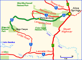
Larapinta Drive is a designated state route in the Northern Territory of Australia.

In the Northern Territory, Highway 1 is a 1,414-kilometre (879 mi) long route with a 316-kilometre (196 mi) long spur, that connects Darwin to northern Western Australia and Queensland. The route traverses the territory, from the Western Australian border near Kununurra, to Katherine, and then across to the Queensland border near Wollogorang, with a spur section linking Katherine to Darwin. Highway 1 continues around the rest of Australia, joining all mainland state capitals, and connecting major centres in Tasmania. All roads within the Highway 1 system are allocated a road route numbered 1, M1, A1, or B1, depending on the state route numbering system. In the Northern Territory, the highway is designated as National Highway 1 where it is concurrent with the National Highway routes linking Darwin to Adelaide and Perth. The eastern section from Daly Waters to Queensland is designated as National Route 1.
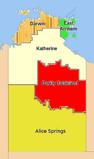
Federal and territory government agencies divide the Northern Territory of Australia into different administrative regions, though their names and boundaries vary.
Main Roads Western Australia controls the major roads in the state's Kimberley region. Great Northern Highway is the major road connection through the region, with sealed roads spurring off it to connect to population centres, and unsealed roads offering an alternative route between Derby and Wyndham.