
Watarrka National Park is a protected area in the Northern Territory of Australia located about 1,316 kilometres south of the territory capital of Darwin and 323 kilometres southwest of Alice Springs.
Yankunytjatjara is an Australian Aboriginal language. It is one of the Wati languages, belonging to the large Pama–Nyungan family. It is one of the many varieties of the Western Desert Language, all of which are mutually intelligible.
Warumpi Band were an Australian country and Aboriginal rock group which formed in the outback settlement of Papunya, Northern Territory, in 1980. The original line-up was George Burarrwanga on vocals and didgeridoo, Gordon Butcher on drums, his brother Sammy Butcher on guitar and bass guitar, and Neil Murray on rhythm guitar and backing vocals. Their key singles are "Jailanguru Pakarnu" (1983), "Blackfella/Whitefella" (1985), "Sit Down Money" (1986), "My Island Home" (1987) and "No Fear" (1987). The group released three albums, Big Name, No Blankets (1985), Go Bush! (1987) and Too Much Humbug (1996). From late 1987 to mid-1995 the group rarely performed as Murray focused on his solo career. In early 1995, Christine Anu, issued a cover version of "My Island Home". Warumpi Band regrouped before disbanding in 2000. Burarrwanga died on 10 June 2007 of lung cancer.

Mutitjulu is an Aboriginal Australian community in the Northern Territory of Australia located at the eastern end of Uluru. It is named after a knee-shaped water-filled rock hole at the base of Uluru, and is located in the Uluru-Kata Tjuta National Park. Its people are traditional owners and joint managers of the park with Parks Australia. At the 2011 census, Mutitjulu had a population of 296, of which 218 (71.2%) were Aboriginal.
The Luritja dialect is the language of the Luritja people, an Aboriginal Australian group indigenous to parts of the Northern Territory and Western Australia. It is one of several dialects in the Western Desert language group.

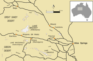
Papunya is a small Indigenous Australian community roughly 240 km northwest of Alice Springs in the Northern Territory, Australia. It is now home to a number of displaced Aboriginal people mainly from the Pintupi and Luritja groups. At the 2016 census, Papunya had a population of 404. Papunya is on restricted Aboriginal land and requires a permit to enter or travel through.
Kukatja, Kukatj, Kokatja or Gugadja may refer to one of several Australian Aboriginal peoples or their languages:
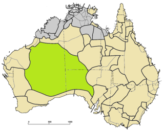
The Western Desert language, or Wati, is a dialect cluster of Australian Aboriginal languages in the Pama–Nyungan family.
Pintupi is an Australian Aboriginal language. It is one of the Wati languages of the large Pama–Nyungan family. It is one of the varieties of the Western Desert Language (WDL).
The Pintupi are an Australian Aboriginal group who are part of the Western Desert cultural group and whose traditional land is in the area west of Lake Macdonald and Lake Mackay in Western Australia. These people moved into the Aboriginal communities of Papunya and Haasts Bluff in the west of the Northern Territory in the 1940s–1980s. The last Pintupi to leave their traditional lifestyle in the desert, in 1984, are a group known as the Pintupi Nine, also sometimes called the "lost tribe".
Aboriginal avoidance practices refers to those relationships in traditional Aboriginal society where certain people are required to avoid others in their family or clan. These customs are still active in many parts of Australia, to a greater or lesser extent.

The MacDonnell Regional Council is a local government area of the Northern Territory, Australia. The region covers an area of 268,329 square kilometres and had an estimated population of 6,863 people in June 2018.

Titjikala is an Aboriginal community in the south of the Northern Territory of Australia. At the 2011 census, Titjikala had a population of 201.
Kukatj, also rendered Gugadj, is an extinct Paman language of the Cape York Peninsula, Queensland, Australia. The name Kalibamu has also been assigned to it, although this may be a separate dialect. It is spoken by the Kukatj people. A single speaker was last recorded in 1975.
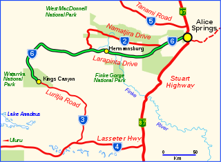
Larapinta Drive is a designated state route in the Northern Territory of Australia.
The Kukatj are an Aboriginal Australian people of the Cape York Peninsula in the state of Queensland. They are to be distinguished from the Kukatja of Western Australia and the Luritja of the Northern Territory, who have also historically been known as Kukatja.
The Luritja or Loritja people, also known as Kukatja or Kukatja-Luritja, are an Aboriginal Australian people of the Northern Territory. Their traditional lands are immediately west of the Derwent River, that forms a frontier with the Arrernte people, with their lands covering some 27,000 square kilometres (10,300 sq mi). Their language is the Luritja dialect, a Western Desert language.
The Yumu were an Indigenous Australian people of the Northern Territory.

The Red Centre Way is a scenic route with a total length of 835 km, consisting of roads named Namatjira Drive, Luritja Road, Larapinta Drive and parts of the Lasseter Highway. Beginning in the city of Alice Springs, it connects the villages of Hermannsburg and Yulara, the Watarrka, West MacDonnell, Fink Gorge and Uluṟu-Kata Tjuṯa National Park, nature reserves such as Tnorala and Alice Springs Desert Park, and deserts, mountain ranges and many other unique tourist attractions.
