Darwin is the capital city of the Northern Territory, Australia. The city has nearly 53% of the Northern Territory's population, with 139,902 at the 2021 census. It is the smallest, wettest, and most northerly of the Australian capital cities and serves as the Top End's regional centre.

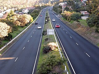
The Brooker Highway is a highway in the Australian state of Tasmania. As one of Hobart's three major radials, the highway connects traffic from the city centre with the northern suburbs and is the major road connection to the cities and towns of northern Tasmania. With an annual average daily traffic of 48,000, the highway is one of the busiest in Tasmania. The Brooker Highway has recently been declared part of the National Highway.

Nightcliff is a northern suburb of the city of Darwin, Northern Territory, Australia. It is the traditional country and waterways of the Larrakia people.

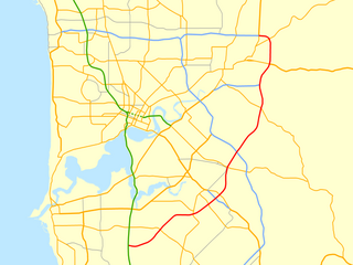
Roe Highway is a 35-kilometre-long (22 mi) limited-access highway and partial freeway in Perth, Western Australia, linking Kewdale with the city's north-eastern and south-western suburbs. The northern terminus is at Reid Highway and Great Northern Highway in Middle Swan, and the southern terminus is with Murdoch Drive at the Kwinana Freeway interchange in Bibra Lake. Roe Highway, in addition to Reid Highway, form State Route 3, a partial ring road around the outer suburbs of the Perth metropolitan area. Roe Highway also forms part of National Highway 94 from Great Eastern Highway Bypass to Great Eastern Highway, and National Highway 95 from Great Eastern Highway to Great Northern Highway.

Wanneroo Road is a 44-kilometre (27 mi) arterial highway in the northern suburbs of Perth, Western Australia linking Joondanna and Yokine in the south with Wanneroo and Yanchep in the north. As part of State Route 60, it begins from Charles Street in the inner city and becomes Indian Ocean Drive up to Dongara.

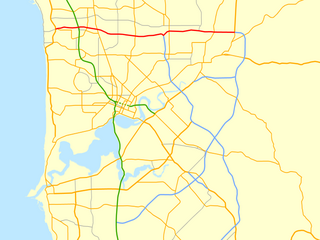
Reid Highway is a 23-kilometre (14 mi) east-west highway and partial freeway in the northern suburbs of Perth, Western Australia, linking North Beach with Middle Swan. As part of State Route 3, it forms half of Perth's outer ring road along with Roe Highway, which it joins onto at its eastern terminus.
Tonkin Highway is an 81-kilometre-long (50 mi) north–south highway and partial freeway in Perth, Western Australia, linking Perth Airport and Kewdale with the city's north-eastern and south-eastern suburbs. As of April 2020, the northern terminus is at the interchange with Brand Highway and Great Northern Highway in Muchea, and the southern terminus is at Thomas Road in Oakford. It forms the entire length of State Route 4, and connects to several major roads. Besides Brand Highway and Great Northern Highway, it also connects to Reid Highway, Great Eastern Highway, Leach Highway, Roe Highway, and Albany Highway.

Leach Highway is a 23-kilometre (14 mi) east-west arterial highway in the southern suburbs of Perth, Western Australia, primarily linking Kewdale and Perth Airport with the city of Fremantle.

The South Arm Highway is a highway serving the southern suburbs of Hobart, on the eastern shore of the River Derwent in Tasmania, Australia. The highway is a major trunk road that carries heavy commuter traffic south from the Eastern Outlet to Howrah and Rokeby. As one of the Tasman Highway's principle Feeders and one of the eastern shore's major transport corridors, The South Arm Highway facilitates the movement of traffic between the suburbs and satellite communities to the south with the city centre and ultimately, other major cross city highways. With annual average daily traffic (AADT) of 17,000, the highway is considered a major traffic corridor within Hobart. The designation "South Arm Highway" arises from its journey south to South Arm.

Millner is a northern suburb in the city of Darwin, in the Northern Territory of Australia. It is the traditional country and waterways of the Larrakia people.

Rapid Creek refers to both a creek in the city of Darwin, Northern Territory, Australia and the name of a suburb north of the city, situated where the creek meets Darwin Harbour. It is the traditional country and waterways of the Larrakia people.

Coconut Grove is a northern suburb of the city of Darwin, Northern Territory, Australia within the local government area of City of Darwin. It is the traditional country and waterways of the Larrakia people.

Tiger Brennan Drive is a major arterial road in the western suburbs of Darwin, Northern Territory, Australia. The road travels southeast–east starting from Darwin CBD toward Darwin's eastern suburb of Berrimah, then continues to a connection with the Stuart Highway at Palmerston. Tiger Brennan Drive runs parallel with the Stuart Highway for most of its length. The road was named after Harold "Tiger" Brennan, a long serving Northern Territory politician and former mayor of Darwin. The road has been assigned the alphanumeric route designation A15 for its entire length.
Gawler Bypass is a major north–south route in the outer northern suburbs of the city of Adelaide, South Australia, connecting Main North Road to the Sturt Highway, bypassing Gawler. The route was built in 1963 in an attempt to redirect traffic on the national highway out of Gawler town centre. It has been upgraded and realigned several times since then.
Fairbairn Avenue is a major arterial road in the eastern suburbs of Canberra, the capital city of Australia. The road travels from a junction with Pialligo Avenue near Canberra Airport to the Australian War Memorial, a distance of 4.2 km (2.6 mi). It is the primary access route to the Australian Defence Force Academy, Campbell Park and Mount Ainslie. Fairbairn Avenue carries the Alternative National Highway 23 designation for a short distance between Majura Road and Morshead Drive. This eastern section suffers from heavy traffic congestion during morning and afternoon peak periods and a number of recent upgrades aim to address this. In 2009, works to improve access and traffic flows around the airport precinct saw Fairbairn Avenue duplicated between Pialligo Avenue – where an existing roundabout was replaced with traffic lights – and Morshead Drive, also improving the intersection with Majura Road. A grade separated interchange constructed over Fairbairn Avenue as part of the Majura Parkway project was completed in 2016.

Bagot Community is an Aboriginal community in the Northern Territory of Australia located in Ludmilla, a northern suburb of the city of Darwin. It was established in 1938 as the Bagot Aboriginal Reserve, when the Aboriginal residents were moved from the Kahlin Compound, it was also sometimes referred to as the Bagot Road Aboriginal Reserve.
Orrong Road is a major arterial road servicing the metropolitan area of Perth, Western Australia as well as the south-eastern continuation of the Graham Farmer Freeway. It is a dual carriageway for its entire length, with multiple sets of traffic lights.

Drumpellier Drive is a north-south road linking Ellenbrook with Reid Highway in the north-eastern suburbs of Perth, Western Australia. The southern section was opened as Lord Street, and was the main link between Ellenbrook and the rest of Perth until the extension of Tonkin Highway north to Gnangara Road. The road corridor has had several proposals put forward for it, including a highway, a bus rapid transitway and a railway. In 2019, a new alignment for Lord Street south of Gnangara Road opened, and it was renamed to Drumpellier Drive, making the naming consistent with the section of road north of Gnangara Road.

Trower Road is a major arterial road in the northern suburbs of Darwin, Northern Territory, Australia. The road is a major access route for services and institutions located in the Casuarina area, including Casuarina Square, Royal Darwin Hospital and Charles Darwin University. The road is named for Horace M Trower, Director of Lands from 1917-21. It is one of the busiest roads in Darwin, used by an average of 27,084 vehicles per day in 2010, behind only Bagot Road and the Stuart Highway. Trower Road provides dual carriageways separated by central median for most of its length, however as many suburban collector roads meet along the route, the maximum speed limit is 70 km/h (43 mph). The road was opened in stages between 1963 and 1969 as development in the northern suburbs progressed. A final extension in 1981 providing access to the Casuarina Coastal Reserve left a section of the road in Brinkin isolated from the main route.


