Gary Junction Road

Last updated

Gary Junction Road

Western Australia
Mount Liebig 9112.jpg
Looking east along Gary Junction Road towards Mt Liebig
General information
Type Track
Length852 km (529 mi)
Built by Len Beadell
Major junctions
ESE end Tanami Road
WNW endGary Junction
Restrictions
Permits3
Fuel supply
FacilitiesBore water, Jupiter well

The Gary Junction Road is an outback unsealed road in Australia built by Len Beadell in the 1960s as part of a network of roads for the Weapons Research Establishment at Woomera, South Australia. In its original form, the Gary Junction Road ran from Liebig bore in the Northern Territory to Callawa Station in Western Australia. On present day maps, it is depicted as running from the Tanami Road (Narwietooma turnoff) to Gary Junction, just east of the Canning Stock Route, a distance of 852 kilometres. [1] The road was named after Beadell's only son Gary.

Contents

History

Beadell and his Gunbarrel Road Construction Party (GRCP) commenced work immediately after completing the Sandy Blight Junction Road in August 1960. Starting from Sandy Blight Junction, the first stage was built towards an existing bore track near Mount Liebig 180 km to the east (67 km west of Papunya). Liebig bore was reached on 16 September. [2] The party then returned to Sandy Blight Junction to continue the western section, with the ultimate goal being Callawa Station near the north-west coast of Western Australia.

Beadell's burnt out ration truck at Kiwirrkurra Community on the Gary Junction Road Beadell's burnt Ration truck.jpg
Beadell's burnt out ration truck at Kiwirrkurra Community on the Gary Junction Road

Construction west of the junction began on 5 October, and the border between the Northern Territory and Western Australia was reached on 12 October. Beadell took star sights and placed a signpost displaying the latitude and longitude to mark the border. The road progressed westward and reached the present site of Jupiter Well on 7 November. The location was about 330 km from Sandy Blight Junction. On 8 November the grader broke down with a major transmission failure. Further road making was interrupted, and a lengthy towing operation of 800 km back to Giles began, using the bulldozer to tow the grader, with the water trailer attached behind it. The average speed of the bulldozer train was 3 km per hour, with an estimate of about a month for the journey. Every two hours while the bulldozer was travelling, a halt for greasing the track rollers was required. [3]

Towing had barely begun when the cook's ration truck with all of its supplies caught fire and was burnt out on 12 November. Beadell was forced to make an emergency trip to Alice Springs to obtain replacement food, a return trip of around 3000 km. Meanwhile, the towing operation continued, and the team was reunited 10 km west of Sandy Blight Junction. The slow moving convoy reached Giles on 26 November 1960. [4]

Completion of the Gary Junction Road was delayed by more than two years, and recommenced in 1963 after the GRCP had built the south to north Gary Highway. Construction began on 18 May 1963 from Gary Junction east towards Jupiter Well to link up with the earlier stage. The road progressed to within a few kilometres of the well, but a large sand dune blocked the way. By using the Land Rover as an anchor, a four-wheel drive truck attached to a long winch cable was able to get up the dune, and the remaining vehicles were successively winched, including lastly the grader. A bulldozer was not part of the road making operation at this time. Jupiter Well was reached on 25 May 1963. [5]

Callawa track

Beadell and the GRCP returned to Gary Junction, and on 4 July started work on a road from there 45 km north-west to intercept the Canning Stock Route at Well 35 (Minjoo). After crossing the stock route, they continued through the Great Sandy Desert battling sand dunes and the salt Percival Lakes to join an existing track at Callawa Station. The connection was made 21 July, and although Beadell preferred the name Gary Junction Road, the track became known as the Callawa track to the west of Well 35. The total distance constructed from Mount Liebig to Callawa was 1350 kilometres. [2]

Supplementary details

A new road between Gary Junction and Well 33 was built by Mike Jenkins and is shown on maps as the Jenkins Track. It is 70 km from Gary Junction to Kunawaritji or Well 33 via the track. A road, part of which is called the Telfer Road, now connects Kunawaritji to Port Hedland on the west coast, via Lake Auld and Marble Bar, thus completing a direct link from the west to Alice Springs.

The position at which the grader's transmission failed was to become known as Jupiter Well ( 22°52′21″S126°35′59″E / 22.87250°S 126.59972°E / -22.87250; 126.59972 (Jupiter Well) ). The well was dug by a survey crew from the National Mapping Council in August 1961, and was named after the planet Jupiter when a member of the survey party noticed a reflection of the planet in the still waters of the well at night.

The Callawa Track had a short functional life, as it was replaced soon after by the Wapet Road (or Kidson Track), and has now become overgrown. Recent maps no longer depict the track. In August 2004, Connie Sue Beadell and mother Anne led a party of eight vehicles along the original Callawa track. Apart from the extensive preparation required beforehand, a fuel drop was necessary at the halfway point. Connie said "The tyres were another issue entirely. The party had a total of 70+ punctures for the whole trip, bearing in mind that 5 of the 8 vehicles that started did not finish the entire distance." The Wapet Road joins the Great Northern Highway near Eighty Mile Beach.

The burnt out ration truck was relocated from its original position ( 22°55′33″S128°00′53″E / 22.92583°S 128.01472°E / -22.92583; 128.01472 (Burnt out Ration Truck) ) to Kiwirrkurra in June 2004 and partially restored.

See also

Related Research Articles

<span class="mw-page-title-main">Connie Sue Highway</span> Track in Western Australia

The Connie Sue Highway is an outback unsealed track that runs between the Aboriginal community of Warburton on the Great Central Road and Rawlinna on the Trans-Australian Railway. It lies entirely in the state of Western Australia, crosses the Great Victoria Desert and Nullarbor Plain, and is approximately 650 km (400 mi) long.

<span class="mw-page-title-main">Gunbarrel Highway</span> Track in Australia

The Gunbarrel Highway is an isolated desert track in the Northern Territory, South Australia and Western Australia. It consists of about 1,350 km (840 mi) of washaways, heavy corrugations, stone, sand and flood plains. The Gunbarrel Highway connects Victory Downs in the Northern Territory to Carnegie Station in Western Australia. Some sources incorrectly show the highway extending west to Wiluna.

<span class="mw-page-title-main">Len Beadell</span> Australian explorer

Leonard Beadell OAM BEM FIEMS was a surveyor, road builder, bushman, artist and author, responsible for constructing over 6,000 km (3,700 mi) of roads and opening up isolated desert areas – some 2.5 million square kilometres – of central Australia from 1947 to 1963. Born in West Pennant Hills, New South Wales, Beadell is sometimes called "the last true Australian explorer".

<span class="mw-page-title-main">Anne Beadell Highway</span> Australian outback track

Anne Beadell Highway is an outback unsealed track linking Coober Pedy, South Australia, and Laverton, Western Australia, a total distance of 1,325 km (823 mi). The track was surveyed and built by Len Beadell, Australian surveyor, who named it after his wife.

<span class="mw-page-title-main">Great Central Road</span> Track in Western Australia and the Northern Territory

The Great Central Road is a mostly unsealed Australian outback highway that runs 1,126 km (700 mi) from Laverton, Western Australia to Yulara, Northern Territory. It passes through a number of small communities on the way.

<span class="mw-page-title-main">Wapet Road</span> Desert track in Pilbara, Western Australia

The Wapet Road, also known as the Kidson Track, is an outback track in the Pilbara region of Western Australia. Since 2014, both the part of the road that is within the native title lands of the Nyangumarta people and the adjacent part between Nyangumarta country and Great Northern Highway are called Nyangumarta Highway.

<span class="mw-page-title-main">Gary Highway</span> Track in Western Australia

The Gary Highway is a remote unsealed track in central Western Australia running through the Gibson Desert and the Great Sandy Desert. It was built by Len Beadell's Gunbarrel Road Construction Party in April and May 1963 and named after Beadell's son, who was born in February that year. It connects the Gunbarrel Highway from Everard Junction in the south, to the Gary Junction Road at Gary Junction in the north. It is one of only two north-south tracks in the central deserts of Western Australia, the other being the Sandy Blight Junction Road, also built by Len Beadell.

<span class="mw-page-title-main">Neale Junction</span> Remote road junction in Western Australia

Neale Junction is an isolated location in the Great Victoria Desert of Western Australia, where the Anne Beadell and Connie Sue Highways intersect. It is 172 km (107 mi) west of Ilkurlka. Neale Junction was named after Commander Frank Neale, who flew a Percival Gull through the area during the Mackay Aerial Reconnaissance Survey Expedition to Western and South Australia in 1935.

<span class="mw-page-title-main">South Carolina Highway 290</span> State highway in South Carolina

South Carolina Highway 290 (SC 290) is a 30.582-mile (49.217 km) state highway in the northwestern part of the U.S. state of South Carolina. It courses through central Greenville and Spartanburg Counties.

<span class="mw-page-title-main">Sandy Blight Junction Road</span> Track in the Northern Territory and Western Australia

The Sandy Blight Junction Road is a remote outback track in Australia joining the Great Central Road, Western Australia and Gary Junction Road, Northern Territory. It was built under the direction of legendary surveyor Len Beadell as part of a network of roads for the Weapons Research Establishment at Woomera, South Australia. It is located approximately 500 km (310 mi) west of Alice Springs.

<span class="mw-page-title-main">Gunbarrel Road Construction Party</span> Team of Australian road builders

The Gunbarrel Road Construction Party (GRCP) was the name bestowed upon a team of road builders by Len Beadell in 1955, after which the well known outback track Gunbarrel Highway was named. Over a period of eight years, Beadell and the GRCP built more than 6,000 kilometres of dirt roads in remote areas of central Australia for the Weapons Research Establishment at Woomera, South Australia.

<span class="mw-page-title-main">Talawana Track</span> Remote track in Western Australia

The Talawana Track is a remote unsealed track that runs between Windy Corner on the Gary Highway and the Marble Bar Road in Western Australia, a distance of 596 kilometres. The majority of it was built by Len Beadell and the Gunbarrel Road Construction Party in 1963 as part of a series of connecting roads for the Woomera rocket range in South Australia. It was the final road they built.

<span class="mw-page-title-main">Mount Davies Road</span> Track in South Australia

Mount Davies Road is a remote unsealed outback track which runs from Mount Davies (Pipalyatjara) in the far north-west corner of South Australia to Anne's Corner on the Anne Beadell Highway 397 kilometres to the south-east. It was built during 1956 and 1957 by the Gunbarrel Road Construction Party (GRCP) surveyed and led by Len Beadell, for the Weapons Research Establishment at Woomera, South Australia.

<span class="mw-page-title-main">Carnegie Station</span> Pastoral lease in Western Australia

<span class="mw-page-title-main">Mount Beadell</span>

Mount Beadell is a mountain located in the Gibson Desert region of Western Australia. It is named after surveyor and explorer Len Beadell, builder of the Gunbarrel Highway. The location is very remote being 155 km (96 mi) west of Jackie Junction and 295 km (183 mi) east of Carnegie Station, the western terminus of the original Gunbarrel Highway.

<span class="mw-page-title-main">Maralinga to Emu Road</span>

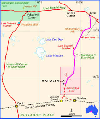
Maralinga to Emu Road is a remote unsealed outback track that links Maralinga to Emu in the western region of South Australia. It was built by Len Beadell for the Weapons Research Establishment of Salisbury, South Australia in 1955.

<span class="mw-page-title-main">Vokes Hill Corner to Cook Road</span> Unsealed outback track in Australia

Vokes Hill Corner to Cook Road is a remote unsealed outback track that links Vokes Hill Corner on the Anne Beadell Highway to Cook on the Trans-Australian Railway in the far west of South Australia. It was built by Len Beadell for the Australian Government's Weapons Research Establishment in late 1961.

<span class="mw-page-title-main">Mount Leisler</span>

Mount Leisler is the highest point in the Kintore Range in the south-west of the Northern Territory of Australia. Its elevation is 897 metres (2,943 ft) AHD .

<span class="mw-page-title-main">Lake Hopkins</span> Salt lake in Western Australia

Lake Hopkins is a salt lake in the east of Western Australia very close to the Northern Territory border. It is located to the west of Lake Neale, which together with Lake Amadeus forms part of a chain of salt lakes that stretches about 500 km (310 mi), from Lake Hopkins in the west to the Finke River in the east. This drainage basin is known as the Amadeus Basin. The lake is usually a dry salt pan, and only holds water for short periods after heavy rainfall. Lake Hopkins has an elevation of 441 metres above mean sea level. The lake proved to be quite an obstacle to progress for Len Beadell during construction of the Sandy Blight Junction Road in 1960.

Callawa Station is a pastoral lease that was once a sheep station but now operates as a cattle station in Western Australia.
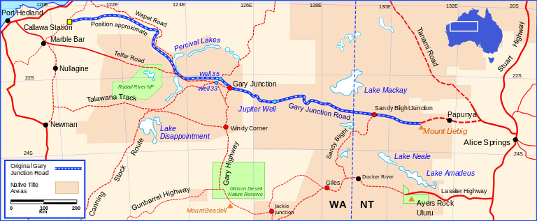
References

  1. Hema, Maps (2005). Australia’s Great Desert Tracks NW Sheet (Map). Eight Mile Plains Queensland: Hema Maps. ISBN   978-1-86500-159-3.
  2. 1 2 Shephard, Mark (1998). A Lifetime in the Bush:The biography of Len Beadell. Adelaide: Corkwood Press. ISBN   1876247053.
  3. Beadell, Len (1976). Beating About the Bush. New Holland Publishers(Australia). ISBN   1876622156.
  4. Bayly, Ian (2009). Len Beadell's Legacy. Seaford Vic: Bas Publishing. ISBN   9781921496028.
  5. Beadell, Len (1983). End of an Era. New Holland Publishers (Australia). ISBN   1864367334.