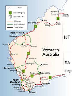
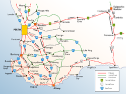
National Highways and Routes in Western AustraliaHighways in south-west Western AustraliaRoad routes in Perth
Road routes in Western Australia assist drivers navigating roads in urban, rural, and scenic areas of the state.[1] The route numbering system is composed of National Highways, National Routes, State Routes, and Tourist Drives. Each route has a unique number, except for National Highway 1 and National Route 1, which mark Highway 1 in Western Australia. Routes are denoted on directional signs and roadside poles by appropriately numbered markers, the design of which varies according to route type.[1]
Many major roads in Perth[4] and in rural Western Australia[5] are not assigned a route number. Not many routes have been added in the Perth and Peel regions since the 1990s with the exceptions including the Graham Farmer Freeway in 2000 and Mandjoogoordap Drive in 2010. A subsequent review of the system was undertaken in 2024 which resulted in additional route numbers being assigned to a number of roads throughout regional Western Australia.[6]
Western Australia is the only remaining state to use the 1950s system in full (other than there being 1 National Route), while other states have either discontinued it in favour of an alphanumeric system or switched to a cheaper hybrid system, followed by phasing out the National Highway system. There are no definite plans to stop using it.
National Highways and Routes
National Highways are designated with gold numbers on a green shield.[1] These are the most direct routes between Perth and other Australian capital cities. Black on white shields indicate National Routes that are not part of the National Highway system.[1]Highway 1 is a route that circumnavigates Australia, joining all mainland state capitals, via roads numbered as National Highway 1 or National Route 1 (or as M1, A1, or B1 in states with an alphanumeric route numbering system).
State Routes in Western Australia are designated by a white number on a blue shield.[1] Single digit routes travel completely or partially along urban freeways or highways. Two digit route numbers that end in zero are the major road routes out of Perth, except for Route 10, which designates rural highway connections in the South West region. Other two digit routes connect the urban centres of Perth, while three digit routes connect regional and remote areas of Western Australia.
Tourist Drives, designated by white numbers on a brown shield, are routes through areas of scenic or historic significance.[1] Tourist Drives were introduced into Western Australia while Eric Charlton was the state government Minister for Transport in the 1990s. The 28 numbered routes collectively traverse more than 2,000 kilometres (1,200mi) across the state.[9] In addition to the Tourist Drives, there are also unnumbered routes such as the Golden Pipeline Heritage Trail,[10] and local governments may designate and maintain local scenic drives, generally unnamed and unnumbered.[11]
1 2 "Explore the Pipeline". Golden Pipeline Heritage Trail. The National Trust of Australia (WA). Section7. Archived from the original on 9 April 2013. Retrieved 19 November 2013.
This page is based on this Wikipedia article Text is available under the CC BY-SA 4.0 license; additional terms may apply. Images, videos and audio are available under their respective licenses.