
The Connie Sue Highway is an outback unsealed track that runs between the Aboriginal community of Warburton on the Great Central Road and Rawlinna on the Trans-Australian Railway. It lies entirely in the state of Western Australia, crosses the Great Victoria Desert and Nullarbor Plain, and is approximately 650 km (400 mi) long.

The Gunbarrel Highway is an isolated desert track in the Northern Territory, South Australia and Western Australia. It consists of about 1,350 km (840 mi) of washaways, heavy corrugations, stone, sand and flood plains. The Gunbarrel Highway connects Victory Downs in the Northern Territory to Carnegie Station in Western Australia. Some sources incorrectly show the highway extending west to Wiluna. The road was built as part of Australia's role in the weapons research establishment called Woomera which included Emu Field and Maralinga, both atomic bomb testing sites. The name comes from Len Beadell's Gunbarrel Road Construction Party so named as his intention was to build roads as straight as a gunbarrel.

Leonard Beadell OAM BEM FIEMS was a surveyor, road builder, bushman, artist and author, responsible for constructing over 6,000 km (3,700 mi) of roads and opening up isolated desert areas – some 2.5 million square kilometres – of central Australia from 1947 to 1963. Born in West Pennant Hills, New South Wales, Beadell is sometimes called "the last true Australian explorer".

The Anne Beadell Highway is an outback unsealed track linking Coober Pedy, South Australia, and Laverton, Western Australia, a total distance of 1,325 km (823 mi). The track was surveyed and built by Len Beadell, Australian surveyor, who named it after his wife. The track passes through remote arid deserts and scrub territory of South Australia and Western Australia, which often have summer temperatures as high as 50 degrees Celsius. Sand dunes predominate for most of the track.

The Great Central Road is a mostly unsealed Australian outback highway that runs 1,126 km (700 mi) from Laverton, Western Australia to Yulara, Northern Territory. It passes through a number of small communities on the way.

The Gary Highway is a remote unsealed track in central Western Australia running through the Gibson Desert and the Great Sandy Desert. It was built by Len Beadell's Gunbarrel Road Construction Party in April and May 1963 and named after Beadell's son, who was born in February that year. It connects the Gunbarrel Highway from Everard Junction in the south, to the Gary Junction Road at Gary Junction in the north. It is one of only two north-south tracks in the central deserts of Western Australia, the other being the Sandy Blight Junction Road, also built by Len Beadell.
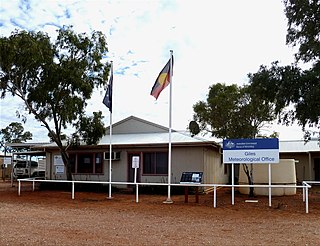
Giles Weather Station is located in Western Australia near the Northern Territory border, about 750 kilometres (470 mi) west-south-west of Alice Springs and 330 kilometres (210 mi) west of Uluru. It is the only staffed weather station within an area of about 2,500,000 square kilometres (970,000 sq mi) and is situated mid-continent and near the core of the subtropical jetstream. This means it plays an important role as a weather and climate observatory for the country, particularly eastern and southeastern Australia, and particularly for rainfall predictions. The station is on the Great Central Road and the nearest township is the Warakurna Aboriginal settlement, 5 kilometres (3 mi) North. Giles is within the Shire of Ngaanyatjarraku and is in the foothills of the Rawlinson Ranges.

The Gunbarrel Road Construction Party (GRCP) was the name bestowed upon a team of road builders by Len Beadell in 1955, after which the well known outback track Gunbarrel Highway was named. Over a period of eight years, Beadell and the GRCP built more than 6,000 kilometres of dirt roads in remote areas of central Australia for the Weapons Research Establishment at Woomera, South Australia. By the time they had completed their work in December 1963, the GRCP had built eleven major roads in twenty-four separate stages across South Australia, the Northern Territory and Western Australia.

The Gary Junction Road is an outback unsealed road in Australia built by Len Beadell in the 1960s as part of a network of roads for the Weapons Research Establishment at Woomera, South Australia. In its original form, the Gary Junction Road ran from Liebig bore in the Northern Territory to Callawa Station in Western Australia. On present day maps, it is depicted as running from the Tanami Road to Gary Junction, just east of the Canning Stock Route, a distance of 852 kilometres. The road was named after Beadell's only son Gary.

The Talawana Track is a remote unsealed track that runs between Windy Corner on the Gary Highway and the Marble Bar Road in Western Australia, a distance of 596 kilometres. The majority of it was built by Len Beadell and the Gunbarrel Road Construction Party in 1963 as part of a series of connecting roads for the Woomera rocket range in South Australia. It was the final road they built.

The Mount Davies Road is a remote unsealed outback track which runs from Mount Davies (Pipalyatjara) in the far north-west corner of South Australia to Anne's Corner on the Anne Beadell Highway 397 kilometres to the south-east. It was built during 1956 and 1957 by the Gunbarrel Road Construction Party (GRCP) surveyed and led by Len Beadell for the Weapons Research Establishment at Woomera, South Australia.
Mount Unapproachable is an isolated mountain in the Northern Territory of Australia located in the locality of Petermann on the northern side of Lake Neale in the territory's southwest. It is about 505 metres (1,657 ft) above sea level. The area is remote: the nearest towns are Kaltukatjara some 116 kilometres (72 mi) away, Kintore some 135 kilometres (84 mi) away and Yulara 138 kilometres (86 mi) away. The mountain is mostly made of sandstone.

The RAAF Woomera Range Complex (WRC) is a major Australian military and civil aerospace facility and operation located in South Australia, approximately 450 km (280 mi) north-west of Adelaide. The WRC is operated by the Royal Australian Air Force (RAAF), a division of the Australian Defence Force (ADF). The complex has a land area of 122,188 km2 (47,177 sq mi) or roughly the size of North Korea or Pennsylvania. The airspace above the area is restricted and controlled by the RAAF for safety and security. The WRC is a highly specialised ADF test and evaluation capability operated by the RAAF for the purposes of testing defence materiel.

Carnegie Station, or Carnegie pastoral lease, is located north of Laverton and east of Wiluna in Western Australia and is the most eastern of pastoral leases found on the Gunbarrel Highway.

Jackie Junction is a remote location in Western Australia on the Gunbarrel Highway. It was named by the road builder Len Beadell after his youngest daughter and is at the junction of the original Gunbarrel Highway and the road to Warburton. It is 69 kilometres (43 mi) north of Warburton.
Giles Airport services the Warakurna Community and the Giles Weather Station in eastern Western Australia. The airstrip was built during April and May 1956 by a team led by Len Beadell as part of establishing the weather station for the British nuclear tests at Maralinga and the Woomera Test Range. It is adjacent to the Gunbarrel Highway and the more recently constructed Great Central Road.

Mount Beadell is a mountain located in the Gibson Desert region of Western Australia. It is named after surveyor and explorer Len Beadell, builder of the Gunbarrel Highway. The location is very remote being 155 km (96 mi) west of Jackie Junction and 295 km (183 mi) east of Carnegie Station, the western terminus of the original Gunbarrel Highway.

The Maralinga to Emu Road is a remote unsealed outback track that links Maralinga to Emu in the western region of South Australia. It was built by Len Beadell for the Weapons Research Establishment of Salisbury, South Australia in 1955.

Mount Leisler is the highest point in the Kintore Range in the south-west of the Northern Territory of Australia. Its elevation is 897 metres (2,943 ft) AHD .

Lake Hopkins is a salt lake in the east of Western Australia very close to the Northern Territory border. It is located to the west of Lake Neale, which together with Lake Amadeus forms part of a chain of salt lakes that stretches about 500 km (310 mi), from Lake Hopkins in the west to the Finke River in the east. This drainage basin is known as the Amadeus Basin. The lake is usually a dry salt pan, and only holds water for short periods after heavy rainfall. Lake Hopkins has an elevation of 441 metres above mean sea level. The lake proved to be quite an obstacle to progress for Len Beadell during construction of the Sandy Blight Junction Road in 1960.


